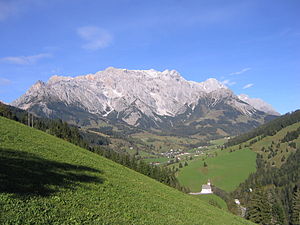
Hochkönig
| Hochkönig | ||
|---|---|---|
|
Hochkönig from the south |
||
| height | 2941 m above sea level A. | |
| location | Salzburg , Austria | |
| Mountains | Berchtesgaden Alps | |
| Dominance | 33.9 km → Zwingkopf | |
| Notch height | 2184 m ↓ Maishofen | |
| Coordinates | 47 ° 25 '13 " N , 13 ° 3' 45" E | |
|
|
||
| rock | Banked Dachstein limestone | |
| Age of the rock | Norium - Rhaetium | |
| First ascent | Visited by locals since ancient times. The first tourist mentioned by name was Karl Thurwieser in 1826 . |
|
| particularities | Highest mountain in the Berchtesgaden Alps | |
The Hochkönig is with a height of 2941 m above sea level. A. the highest mountain range in the Berchtesgaden Alps . The main summit, which is also called Hochkönig, towers over all mountains within a radius of around 34 kilometers. With a notch height of 2,181 m, the Hochkönig is one of the geographically most prominent mountains in the Alps, only surpassed by Mont Blanc , Grossglockner , Finsteraarhorn , Wildspitze and Piz Bernina .
geography
The mountain range of the Hochkönig consists of a moderately north-sloping, approximately 12 km² large plateau, which breaks off to the south with up to 1,000 m high rock walls and towers against the much lower green slate mountains of the Dientener Berge . On the corridor of the summit is the Übergossene Alm , a crevice-free plateau glacier that descends to around 2,600 to 2,700 m. In 1888 the glacier area was around 5.5 km². In the meantime, the Übergossene Alm has melted down to less than 1.5 km².
The edge of the summit plateau is formed by an approximately circular mountain range:
- High rope , 2793 m above sea level A.
- Lammkopf , 2844 m above sea level A.
- Hochkönig, 2941 m above sea level A.
- Big viola head , 2859 m above sea level A.
- Small viola head , 2684 m above sea level A.
- Gate pillar , 2587 m above sea level A.
- Schoberköpfe , 2707 m above sea level A. , 2630 m above sea level A. and 2663 m above sea level A.
- Floßkogel , 2437 m above sea level A.
- Eibleck , 2354 m above sea level A.
- Hohes Tenneck , 2,435 m above sea level A.
The Hochkönig is connected to the Steinernes Meer in the west via the Gatescharte . To the north it is separated from the Hagengebirge by the Blühnbachtal , to the east by the deeply cut Salzach Valley from the Tennengebirge .
In the valley are the villages of Maria Alm , Dienten and Mühlbach , as well as the town of Bischofshofen , Ort and Burg Werfen and Tenneck in the main valley of the Salzach .
geology
As in general in the Berchtesgaden Alps, the mountain base of the Hochkönig consists of brittle Ramsaudolomite . In the summit area, on the other hand, the firmer Dachstein limestone predominates. While the Dachstein limestone on the Watzmann in the Bavarian part of the Berchtesgaden Alps is in the form of the bank limestone , the Hochkönig is mainly reef limestone from the primeval Tethys .
Huts and climbs
The Hochkönig was climbed early on by local hunters. The first tourist ascent of the main summit was made by theology professor Peter Carl Thurwieser on September 5, 1826, using today's normal route through the Ochsenkar from the Arthurhaus . He was accompanied by two officers, Ernst von Joanelli and von Sax, and ten porters. The surveyor Ernst von Joanelli intended to take measurements on the summit. The ascent from the Birgkarhaus (large parking lot) through the Birgkar to the plateau is shorter, but far more dangerous and physically more strenuous than this easiest route to the Hochkönig . In winter, the route over the Floßkogel to Werfen or Tenneck is the longest ski touring descent in the Eastern Alps.
The Matrashaus , a hut belonging to the Austrian Tourist Club , stands on the Hochkönig summit at an altitude of 2941 m . The summit is a first-order trigonometric point and a popular starting point for hang-gliders and paragliders .
The Bertgenhütte (a bivouac box ), the Erichhütte , the Arthurhaus, the Mitterfeldalm and the Ostpreußenhütte also serve as bases for mountaineers .
Since 2015, the Hochkönigman , one of the most demanding mountain marathons among trail running competitions in Austria, has been held annually in the region on and around the Hochkönig .
Mining
At the foot of the Hochkönig, in the Mühlbach area, south of the Arthurhaus on the Mitterberg, has been going on since the Neolithic period from around 3000 BC. Until 1977 copper mining operated. Iron ore was mined at the exit of the Blühnbach Valley near Tenneck until 1960 .
gallery
literature
- Albert Precht : Alpine Club Leader Hochkönig. Bergverlag Rother , Munich 1989, ISBN 3-7633-1259-5 .
Web links
Individual evidence
- ↑ Height of the Maishofen valley watershed ( 757 m ) according to OpenTopoMap [1] .
- ^ Geological map of Salzburg 1: 200,000 , Federal Geological Institute 2005.
- ↑ See list of the most prominent mountains in the Alps .
- ↑ Eduard Richter : The Development of the Eastern Alps Volume 1 . Publisher of the German and Austrian Alpine Association, 1893, p. 269.


