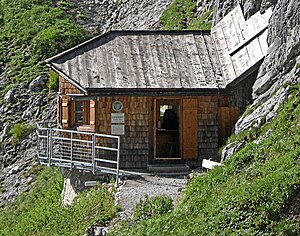
Bertgenhütte
| Bertgenhütte ÖTK self-catering hut |
||
|---|---|---|
| location | Snow car; Salzburg , Austria ; Valley location: Maria Alm am Steinernen Meer | |
| Mountain range | Berchtesgaden Alps | |
| Geographical location: | 47 ° 25 '25 " N , 13 ° 1' 32" E | |
| Altitude | 1846 m above sea level A. | |
|
|
||
| owner | Maria Alm section of the ÖTK | |
| Construction type | Self-catering hut | |
| Usual opening times | all year round (self-catering) | |
| accommodation | 0 beds, 12 camps | |
| Web link | Bertgenhütte | |
| Hut directory | ÖTK DAV | |
The Bertgenhütte is a small self-catering hut in the Maria Alm section of the Austrian Tourist Club at 1,846 m above sea level. A. Höhe im Schneekar at the foot of the Hochseiler in the Hochkönig area . It is always open and accessible to every mountaineer, but is not supervised. There is a water point in the immediate vicinity of the hut, otherwise you have to bring your own provisions and drinks. The Bertgenhütte is generally not suitable for groups, as only 12 beds are available. Further information is available from the hut warden Josef Kysela from Maria Alm.
history
The first hut in the Schneekar only served as temporary accommodation for the builders of the trail from Hinterthal to the Hochkönig. The starting point for the enormously long march was still Saalfelden at that time , as there was no road to Hinterthal. In 1895 the hut was destroyed by an avalanche. Their location was around 100 meters above today's Bertgenhütte. In the same year, the Maria Alm section of the tourist club began rebuilding, but where it is today. From 1920 to 1935 there were even tenants for the Bertgenhütte, whose main income consisted of mountain tours on the Hochkönig. In 1995 the tourist club wanted to renovate the Bertgenhütte, but repairing the dilapidated foundation was out of the question, so the hut was rebuilt. It was flown to the site by helicopter and set up and assembled there. There are always problems with avalanches and falling rocks, but it is the only place on the way with water, so the location was inevitably retained.
Accesses
- From Hinterthal via the Hüttenweg, medium, walking time: 2.5 hours
Transitions
- Erichhütte ( 1545 m above sea level ) via Poschalm, easy high path, walking time: 3 hours
- Franz-Eduard-Matras-Haus ( 2941 m above sea level ) over the Teufelslöcher and the Übergossene Alm , difficulty level II according to UIAA , partly secured, walking time: 4 hours
Mountaineering
- High rope ( 2795 m ) over Teufelslöcher, difficulty level II according to UIAA, partly secured, walking time: 3 hours
- Hochkönig ( 2941 m ) via Teufelslöcher and Übergossene Alm, difficulty level II according to UIAA, partially secured, walking time: 4 hours.

