
Müllnerberg
| Müllnerberg, Müllnerhorn | ||
|---|---|---|
 Seen from Karlstein (west) |
||
| height | 1373 m | |
| location | Upper Bavaria | |
| Mountains | Chiemgau Alps | |
| Coordinates | 47 ° 42 '27 " N , 12 ° 50' 8" E | |
|
||
| Normal way | Kugelbachweg - Paul Gruber House - Müllnerhorn | |

The Müllnerberg forms the southwestern part of the Bad Reichenhall valley basin. It lies between the Karlstein district , the Saalachtal with the Saalachsee , Schneizlreuth and the Thumsee . The locals usually name the whole mountain after just one of the three peaks: the Müllnerhorn (also: Müllnerhörndl ).
summit
The highest peak is the Rabensteinhorn at 1,373 meters ( ⊙ ), followed by the Pflasterbachhorn (also Pflasterbachhörndl ) at 1,370 meters ( ⊙ ) and the Müllnerhorn at 1,253 meters ( ⊙ ). Although the Müllnerhorn itself is the lowest peak of the mountain, it is in front of the other two and with its distinctive shape can be seen very well from Reichenhall and Karlstein. The eastern branch with a height of 770 m is called the mayor's height ( ⊙ ).
Ascent
Several marked paths lead to the three peaks. From the north from Kugelbachweg over the listed Kugelbachbauern ( ⊙ ) and past the no longer managed Paul-Gruber-Haus ( ⊙ ) der Naturfreunde and the Kugelbachalm . From the northwest from Antoniberg via the Paul-Gruber-Haus or from the east via the Bürgermeisterhöhe.
Although the absolute height is rather low compared to the other peaks around Bad Reichenhall, the ascent requires mountain experience and local knowledge. The Müllnerberg is known for many rockfalls and loose rock, some of which require very narrow paths to be sure-footed and a head for heights. Due to the low altitude, the not harmless ascent and the lack of a hosted hut, the Müllnerberg is not a heavily frequented mountain. But it offers mountain climbers peace and quiet and a shady path even in midsummer.
Climb

The south face of the 682 m high Knogl (also: Kugelbachblock ) ( ⊙ ) east of the Kugelbachbauern is a popular climbing wall in Bad Reichenhall. It is very well developed and also suitable for less experienced climbers. But even experienced athletes like to use the wall to prepare for demanding tours in the Alps. The German Alpine Club has a total of eight routes with a UIAA difficulty level from VI to IX.
The well-known Bavarian mountaineer Alexander Huber climbed the Shogun route on the Müllnerberg in 1991 with a difficulty of XI-, the Adrenalin (XI-) and Headline (X +) routes followed in 2001. All three were repeated by his brother Thomas .
Caves and ravines
- The Teufelshöhle ( ⊙ ) is about halfway between the former Gasthof Schroffen and the Bürgermeisterhöhe. It takes its name from a devil that an unknown artist painted on a rock wall. He marks the entrance to the cave. The cave itself is not large but sloping and therefore cannot be entered without safety and suitable equipment. A good 100 meters north of the entrance to the cave is the Kirchberg pulpit , from which you have a panoramic view of Kirchberg, Nonn and the city of Bad Reichenhall.
- The Kreissenhöhle , rarely also the Kreissenschlucht or Kreissenklamm ( ⊙ ), is on the way from the Schroffen to the Kugelbachbauern, above the Saalach power plant . The path used to lead through the cave, but after it had partially collapsed in the 1990s, the path was led past with metal stairs above the cave.
- The Reischlklamm ( ⊙ ) is also signposted like the Teufels- und Kreissenhöhle and is located next to the road to the Kugelbachbauern. The gorge itself is only to be entered with caution and appropriate equipment, rock falls must be expected at all times. In a southerly direction from the gorge you get further into a crevice, where the watercourse is also found, which is the basis for the name “ gorge ”. Climbing hooks are attached to the west wall of the gorge, the German Alpine Club indicates the level of difficulty as 1 × VI, 2 × IX and 2 × X. An iron bridge leads over the gorge, the access to it is also signposted with signposts.
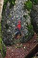
Entrance to the devil's cave

Reischlklamm


Geography and history
The former Kirchberger Heilquelle ( ⊙ ) rises at the foot of the eastern foothills , which was the basis for the spa in Kirchberg from the early 18th century .
The Gfällgraben and Amerangbachl originate at Müllner Berg and unite near the Brunnhaus Seebichl or Seebach Chapel with the Seebach .
The philanthropist Alfred Nathan had the Amalienruhe ( ⊙ ) built not far from the road to the Kugelbachbauern . This building, open to the east, is reminiscent of a chapel and is intended to serve as a memory of his mother, who enjoyed the view of the city from this hill.
The pressure tunnel, which supplies the Saalach power plant with water from the Saalachsee , crosses under the eastern foothills of the mountain.
In the Müllnerberg area there are also the ruins of several fortified structures. Fager ( ⊙ ), Amerang ( ⊙ ) and Kirchberg ( ⊙ ) were built by the Archbishop of Salzburg and probably all around 1262 by the Bavarian Duke Heinrich XIII. destroyed. The toll to Karlstein ( ⊙ ) was set up by the Peilsteiners and was probably abandoned after their disappearance in 1218. Only a few remains of the wall are left of all the facilities, these are located in the forest and are not accessible to the public. Since the terrain is unpaved, there is a risk of falling in many places. The facilities are part of the Reichenhaller Burgenweg .
The goat whey from the Kugelbachalm was used in the cure in Kirchberg and Bad Reichenhall in the 19th and 20th centuries and was delivered fresh every day.

View from Sieben- Palfen- Weg. On the left the church of St. Pankraz , in the middle the Müllnerhorn, on the right the Gebersberg
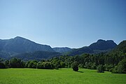
View from Nonn. Left the Lattengebirge, right the Müllnerhorn
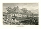
Engraving by Reichenhall, around 1850

Summit cross on the Pflasterbachhörndl


Web links
![]() Map with all coordinates: OSM | WikiMap
Map with all coordinates: OSM | WikiMap
- Kugelbachbauer - restaurant on the way to the Müllnerhorn
- Private website with route description and lots of photos
- Round trip around the Müllnerberg and on the Rabensteinhorn - route with pictures, GPS data and information about the brine pipeline
Individual evidence
- ↑ Location of the rocks in the Karlstein climbing garden
- ↑ German Alpine Club rock information system. Retrieved February 28, 2016.
- ↑ The eleventh degree ( memento of December 13, 2004 in the Internet Archive ), Adrenalin ( memento of June 30, 2013 in the web archive archive.today ), Adrenalin - Thomas and the eleventh degree ( memento of August 30, 2007 in the Internet Archive ), Huberbuam.de, accessed on May 2, 2013
- ↑ German Alpine Club rock information system. Retrieved February 28, 2016.
- ↑ Reichenhaller Burgenweg - online version