Gebersberg
| Gebersberg
Kranzlstein ( Kranzlstoa )
|
||
|---|---|---|
|
View from Sieben-Palfen-Weg |
||
| height | 1052 m above sea level NHN | |
| location | Upper Bavaria | |
| Mountains | Chiemgau Alps | |
| Dominance | 0.45 km → Scharnrücke | |
| Notch height | 102 m ↓ Kugelbachalm | |
| Coordinates | 47 ° 42 '47 " N , 12 ° 49' 35" E | |
|
|
||
| Normal way | from Thumsee, Seemösl car park | |
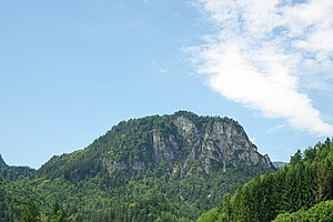
The Gebersberg lies between the Müllnerberg , from which it is only separated by a valley cut, and the state road 2101 . It forms the eastern end of the Bad Reichenhall valley basin. The most famous peak is the Kranzlstein at 970 m, after which the mountain is usually only named (in Bavarian Kranzlstoa ). The Mountain Costume Conservation Association (GTEV) Kranzlstoana Karlstein e. V. got its name from this summit.
The ascent can be made directly from Thumsee , from Nesselgraben or from Paul-Gruber-Haus. The path is not signposted in places and requires surefootedness, a head for heights and local knowledge. The summit offers a clear view of the Reichenhall valley basin and the Thumsee.

View from Sieben- Palfen- Weg. On the left the church of St. Pankraz, in the middle the Müllnerhorn, on the right the Gebersberg

