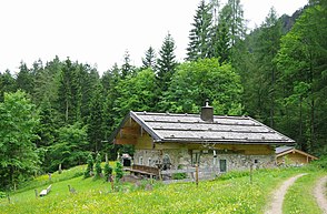
Kugelbachalm
| Kugelbachalm | ||
|---|---|---|
|
Kaser of the Kugelbachalm |
||
| location | Bad Reichenhall , Upper Bavaria | |
| Mountains | Müllnerberg , Chiemgau Alps | |
| Geographical location | 47 ° 42 ′ 9 ″ N , 12 ° 49 ′ 19 ″ E | |
|
|
||
| Form of ownership | Private valley | |
| height | 920 m above sea level NN | |
| use | abandoned | |
| particularities | Some of the building materials are said to come from Amerang Castle | |
The Kugelbachalm is a no longer managed Alm in the district of Karlstein in Bad Reichenhall .
The alpine hut is under monument protection and is registered under the number D-1-72-114-191 in the Bavarian monument list.
history
The building was erected in the 17th or 18th century. It is said that the marble window and door frames come from the Amerang tower ruins . The ground floor quarry stone building is bare with vaults in the interior. In the 19th and 20th centuries, among other things, the goat whey from the Alm was used for cures and the health resorts in Kirchberg and Bad Reichenhall and was freshly delivered every day.
Origin of name
The name comes from the Kugelbach, which rises to the west of the Alm and flows into the Weißbach near Schneizlreuth . The Kugelbachbauer further east bears the same name.
location
The Kugelbachalm is located on the Müllnerberg not far from the Paul Gruber House at an altitude of 915 m above sea level. NHN . The Alm can only be reached via a non-public forest road , footpaths lead, among other things, over the Pfenniglandl , the Gebersberg and over the summit of the Müllnerberg.
Web links
- Obere Kugelbachalm . In: Agricultural and cultural heritage database . Society for Agricultural History
literature
- Johannes Lang : History of Bad Reichenhall. Ph.CW Schmidt, Neustadt / Aisch 2009, ISBN 978-3-87707-759-7 .

