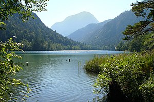
Thumsee
| Thumsee | ||
|---|---|---|

|
||
| Thumsee, looking south-west | ||
| Geographical location | District of Berchtesgadener Land , Bavaria | |
| Tributaries | Nesselgraben → (Egelsee) → underground | |
| Drain | Seemösl (Seerosensee) → Seebach → Hosewaschbach → Saalach | |
| Location close to the shore | Bad Reichenhall | |
| Data | ||
| Coordinates | 47 ° 43 '8 " N , 12 ° 49' 27" E | |
|
|
||
| Altitude above sea level | 526.8 m above sea level NN | |
| surface | 15.55 hectares | |
| length | 889 m | |
| width | 325 m | |
| volume | 1,110,000 m³ | |
| scope | 2.46 km | |
| Maximum depth | 21 m | |
| Middle deep | 8 m | |
| Catchment area | 4.5 km² | |

|
||
| Gasthaus Seewirt on the north bank | ||
The Thumsee (from the Latin word dumosus , German overgrown with scrub ) is a lake in the Karlstein district a good three kilometers west of the city center of Bad Reichenhall and around 1400 meters west of the center of Karlstein in the Berchtesgadener Land district in southern Bavaria ( Germany ) privately owned. Likewise Thumsee the name of Bad Reichenhall local part, which is in the north and northeast of the lake.
description
The lake is located in an eponymous conservation area . It is around 1 kilometer long and around 325 meters wide. Its deepest point is 21 m below the water surface. The Thumsee is a very popular bathing lake in the Bad Reichenhall area in summer, there is a public sunbathing area as well as the Thumseebad , a swimming pool with the appropriate infrastructure and a terrace café . A circular hiking trail and two excursion restaurants attract walkers all year round. The lake is connected to public transport by a city bus from the Bad Reichenhall municipal utility .
A special feature is located in the vicinity of the lake to the small sump pond "Seemösl" or "Seerosensee" lilies Farm . It was laid out in 1936, making it the oldest in Germany. Nine different varieties were bred here. Since the complex is no longer maintained, almost no water lilies bloom there anymore.
The lake flows over the Seemösl and then over the Seebach (from Nonn Hosewasch or Hoswaschbach). In the southwest is the main tributary Nesselgraben, which seeps away for the last three to four hundred meters and flows underground to the lake. The Egelsee is still shown here on the official topographical map from 1959 . As early as 1841, however, it was said about this earlier lake: “ To the south-west ... there is a small lake in Nößlgrabenthal called Egelsee, which has now almost dried up. “The Thumsee is characterized by its clear water and abundance of fish.
On April 13, 2007 and July 27, 2013, after a long period of drought, there was a three-day forest fire on the neighboring Antoniberg , which affected around 20 to 30 hectares of protective forest . A disaster had to be declared. The Thumsee served as a source of extinguishing water for the fire brigades and at times up to 9 helicopters who fought the fire with extinguishing water tanks .
Web links
Individual evidence
- ↑ bgland24.de: The Thumsee now belongs to Thomas Schmid (April 23, 2013)
- ↑ a b c d e f Thumsee on the website of the Traunstein Water Management Office.
- ↑ Calculation from area and mean depth
- ↑ Directory of the Bay. State library online
- ↑ Bavarian State Surveying Office: Topographische Karte 1:25 000, sheet 8242 Inzell, preliminary edition. Munich 1959
- ↑ Franz Xaver Huber: Agrikole statistics or description of the farm District No. 23 Reichenhall in the kingdom of Bavaria, in Upper Bavaria, Reichenhall. 1842 , p 25
- ^ Mission report of the Bad Reichenhall volunteer fire brigade about the forest fire on Antoniberg 13.-16. April 2007 , last accessed December 2, 2015
