
Thumsee (Bad Reichenhall)
|
Thumsee
City of Bad Reichenhall
Coordinates: 47 ° 43 ′ 20 ″ N , 12 ° 49 ′ 55 ″ E
|
|
|---|---|
| Height : | 554 m |
| Residents : | 36 (May 25 1987) |
| Postal code : | 83435 |
| Area code : | 08651 |
 Houses of the district on the north bank of the Thumsee
|
|
Thumsee is a district of the city of Bad Reichenhall in the district of Berchtesgadener Land , or the former municipality and today's Reichenhaller district Karlstein .
State road 2101 leads directly past the lake of the same name . The road is very winding and a hot spot for accidents.
geography
The district is in the north and north-east (street name Thumsee ) and in the southwest (street name Nesselgraben ) of Thumsees . The district and lake are in turn in the southwest of Bad Reichenhall, framed by the Gebersberg (with Kranzlstein) in the south and the Heuberg in the north. The actual district of Thumsee (street name Thumsee ), i.e. without the Nesselgraben, is divided into a western and an eastern part, since the direct, approximately 200-meter-long road connection between house numbers 5 and 6 is interrupted by a bollard and the road traffic in the south around the Thumsee must flow around on State Road 2101 , increasing the road distance to 2.7 km.
history


The previously local part name Thumsee was officially awarded on November 26, 1954. At that time it consisted of an exclave of the municipality of Karlstein, which was surrounded by the former municipality-free area of Forst Karlstein , which was only incorporated into the municipality in the same year. It appears for the first time in the official gazette of 1961 and subsequently in the gazette of 1970. In the last gazette (for the 1987 census) it is recorded with 36 inhabitants, 12 buildings with living space and 18 apartments.
Earlier (1840) the properties of today's Thumsee were counted as part of the scattered village of Karlstein (with a total of 51 houses or 34 named wastes ). Thumsee as a place name is not yet mentioned in the publication from 1840. The individual properties in the area of today's Thumsee were, from west to east, Madlbauer ( Maadelbauer, also Mandelbauer , today house number 2), Kecht ( also Keck , house number 4), Banholzer ( Bannholzer , house number 6), Berner ( also Berger , house number 8 ) and Seeweber (house number 9), all marked with 1 H. (one house). The Seewirt located west of the Madlbauer (former Villa Pachmayr from 1873, house number 1) did not exist at that time. The other house numbers of the current street name Thumsee , which range up to 14 (i.e. without Nesselgraben , which is the second street name within the Thumsee district) were built later.
The Nesselgraben also appeared under the wasteland of Karlstein , with the entry: Nesselgraben, E. bey Schnaizlreut, 2 H. belonging to Karlstein .
In a statistical overview from 1841, however, the town of Thumsee is already mentioned .
Until the beginning of the 20th century, the brine pipeline ran from Bad Reichenhall to Traunstein through the Nesselgraben. With the two well houses in Unter- and Obernesselgraben , a height difference of 97 meters was overcome.
Buildings
In addition to residential buildings, guest houses, a hotel and the Thumseebad, there are several listed objects on Thumsee. The Gasthaus Seewirt , part of the brine line from Bad Reichenhall to Traunstein and Rosenheim and the Antoniberg chapel . The on- site shooting range for the Reichenhaller barracks was built in the Nesselgraben .
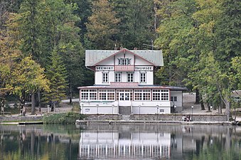
Gasthaus Seewirt (2011)
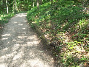
Part of the wooden brine pipe above the Thumsee

Antoniberg Chapel


Individual evidence
- ^ Bavarian State Ministry of the Interior, AZ IB 1 - 3000 - 45 a / 58, November 26, 1954
- ^ Official register of places for Bavaria, territorial status on October 1, 1964 with statistical information from d. 1961 population census, Munich, 1964 , column 52
- ↑ Official directory for Bavaria, Munich, 1973 , p. 522
- ↑ Official directory for Bavaria, territorial status: May 25, 1987, Munich, 1991 , p. 70.
- ^ Repertory of the topographical atlas sheet Reichenhall, 1840 as well as original position sheet in the BayernAtlas
- ↑ Franz Xaver Huber: Agrikole Statistics or description of the agricultural district No. 23 Reichenhall in the Kingdom of Bavaria, namely in Upper Bavaria, Reichenhall 1842 , p. 47
Web links

Bad Reichenhall | On the sermon chair | Karlstein | Kirchberg | Marzoll | Nonn | Schwarzbach | St. Zeno | Thumsee | Turk | Weissbach