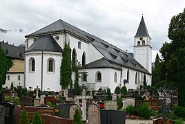
St. Zeno (Bad Reichenhall)
|
St. Zeno
Bad Reichenhall municipality
Coordinates: 47 ° 43 ′ 53 ″ N , 12 ° 53 ′ 20 ″ E
|
|
|---|---|
| Height : | 475 m |
| Area : | 1.66 km² |
| Residents : | 25 (May 25 1987) |
| Population density : | 15 inhabitants / km² |
| Incorporation : | December 1, 1905 |
| Postal code : | 83435 |
| Area code : | 08651 |
St. Zeno is a district of Bad Reichenhall . Until 1905 St. Zeno was an independent municipality with the center one kilometer northeast of Reichenhall city center, and with an area of 165.95 hectares and 921 inhabitants (status: 1904). According to the last census on May 25, 1987, only two "buildings with living space" (monastery buildings) with 25 inhabitants were counted as part of the St. Zeno district, while the remaining areas of the former municipality are considered to have merged with Bad Reichenhall.
Location and structure
The former municipality of St. Zeno was divided into five districts with the villages of St. Zeno and Froschham and the hamlets of Leopoldsthal , Traunfeld and Vogelthenn. In the first official place directory from 1875, the deserted Wegscheid and Reichenhall train station were also identified as further independent districts. However, the district does not border on the former municipality-free area of Forst St. Zeno , as could be assumed due to the similarity of names.
history
The place is named after the former monastery of the Augustinian Canons . The most striking building is the church of St. Zeno , which is attached to the monastery and is considered the largest Romanesque church in Upper Bavaria .
Due to the boom as a spa , there was brisk construction activity in the main town of Bad Reichenhall at the end of the 19th century . Due to the possibilities for spatial development given by the topography, 61 of the 200 villas and country houses built were soon in the municipality of St. Zeno, which encouraged the growing together and ultimately the incorporation.
On December 1, 1905, the main part of the community with the districts of St. Zeno, Froschham, Traunfeld and Vogelthenn was incorporated into Bad Reichenhall. These former districts are no longer differentiated within Bad Reichenhall or have all merged into St. Zeno as a district of Bad Reichenhall. The hamlet of Leopoldsthal directly on the Austrian border, an exclave of less than eight hectares separated from the rest of the municipality by the Kirchholz , went to the municipality of Bayerisch Gmain at the same time as its 14 inhabitants , but was also included in it as a separate district according to the official register of places for the last time in 1925 recorded.
On January 1, 1981, the district increased by around 56 hectares when part of the disbanded municipality-free area Kirchholz was incorporated into Bad Reichenhall and the district of St. Zeno was added (the greater part of Kirchholz came to Bayerisch Gmain).
School location
Part of the monastery building now houses the girls' secondary school of the Archdiocese of Munich and Freising . In the immediate vicinity of the monastery, Josef Freiherr von Karg-Bebenburg (1833–1899) acquired a piece of land in 1868 and built a villa with a park on it in 1871. Today the Villa Karg is part of the Karlsgymnasium, the park of the Karlspark. Today, St. Zeno is also the location of the St. Zeno School (middle school), the Special Education Center and the Steigenberger Hotel Management School. The area of the ice rink, which collapsed in 2006 , is also in the immediate vicinity of the schools. In September 2009, the Bad Reichenhall campus of the IUBH School of Business and Management was to be built on this site after the ice rink was demolished . Today, however, the campus is located at the hotel management school, after the university did not extend the long-term lease agreement for the area of the collapsed ice rink in 2013 due to the foreseeable insufficient occupancy. The site is therefore still undeveloped (as of 2015).
literature
- The "incorporation" of the community of St. Zeno Heimatblätter - supplement from Reichenhaller Anzeiger and Freilassinger Tagblatt - issue no. 6 of June 3, 2006 PDF file, 390 kB, accessed on March 13, 2011
Web links
Individual evidence
- ↑ Bavarian State Office for Statistics and Data Processing (Ed.): Official local directory for Bavaria, territorial status: May 25, 1987 . Issue 450 of the articles on Bavaria's statistics. Munich November 1991, DNB 94240937X , p. 70 ( digitized version ).
- ^ Directory of the Kingdom of Bavaria, with alphabetical register of places, Munich, 1904
- ↑ Kgl. Statistical Bureau (ed.): Complete list of localities of the Kingdom of Bavaria. According to districts, administrative districts, court districts and municipalities, including parish, school and post office affiliation ... with an alphabetical general register containing the population according to the results of the census of December 1, 1875 . Adolf Ackermann, Munich 1877, 2nd section (population figures from 1871, cattle figures from 1873), Sp. 54 , urn : nbn: de: bvb: 12-bsb00052489-4 ( digitized version ).
- ↑ dpa: University on the area of the collapsed Reichenhaller ice rink , report in Münchner Merkur , online from May 7, 2009 at merkur.de
- ↑ Campus Bad Reichenhall ( Memento of the original from June 23, 2015 in the Internet Archive ) Info: The archive link has been inserted automatically and has not yet been checked. Please check the original and archive link according to the instructions and then remove this notice. , Website for the Bad Reichenhall location of the IUBH School of Business and Management , online at iubh.de
- ↑ No new campus on Münchner Allee , online at heimatzeitung.de on October 7, 2013.

