
Untersberg
| Untersberg | ||
|---|---|---|
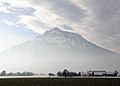
 Untersberg massif seen from Salzburg |
||
| height |
1972 m above sea level NHN ( Berchtesgadener Hochthron ) |
|
| location |
Bavaria , Germany Salzburg , Austria |
|
| Mountains | Berchtesgaden Alps | |
| Dominance | 11.5 km → Hoher Göll : Mannlgrat | |
| Notch height | 1279 m ↓ Hallthurm | |
| Coordinates | 47 ° 42 '19 " N , 12 ° 58' 45" E | |
|
||

The Unterberg is the northernmost massif of the Berchtesgaden Alps , a distinctive landmark on the edge of the Alps . It is located in the states of Bavaria ( Germany ) and Salzburg ( Austria ). With an otherwise pronounced summit plateau, the approximately 70 km² massif has the main peaks Berchtesgadener Hochthron ( 1972 m above sea level ) and Salzburg Hochthron ( 1853 m above sea level ).
Within the massif there are numerous caves, including the Schellenberger Ice Cave , which has been developed as a show cave, and the Riesling-Schachthöhle , which is at least 20.3 km the longest and with over 1149 m the deepest cave in Germany. This wealth of caves is the starting point for numerous legends and myths that entwine around the Untersberg.
geography
location
The Untersberg lies between Berchtesgaden in the south and Salzburg in the north-northeast and rises with its north flank directly from the edge of the Salzburg basin with a free profile height of over 1400 meters. It is separated by the Berchtesgaden valley from the Dürrnberg- Zug via Hallein and the Göllstock in the southeast, the wide inner-alpine "basin landscape" of the Berchtesgaden basin and the geomorphological unit Berchtesgaden basin with the Watzmannstock in the south and the Lattengebirge in the south-west and rises in the north-west , separated by the Reichenhall basin , the Hochstaufen .
Around two thirds of its territory is in Bavaria, the state border with Austria runs through the northern part over the peaks of the main chain of Hirschangerkopf , Ochsenkopf , Mitterberg and Salzburger Hochthron . From north to south, the eastern edge of the plateau is formed by the Rauheck , the Gamsalpkopf and the Berchtesgadener Hochthron , which is the Untersberg's highest point at 1972 m . The summit visible to the north is the pre-summit of the Salzburg high throne, the Geiereck . To the northeast, the plateau breaks off into the Rositten high valley , upstream is the ridge of the Leonhardspitze towards Grödig .
The Untersberg has some foothills such as Nierntalkopf , Raunenköpf , Kneifelspitze , Kiliansberg , Gschirrkopf , Eckberg and Hochzinken in its south-eastern side peaks .
summit


The peaks (the highest is printed in bold ) with secondary peaks of the Untersberg and its foothills include (the mountain range / group is viewed approximately in a north-east-south-west direction) - with height in meters (m) above sea level for the German Land Bavaria and meters above the Adriatic Sea for the Austrian Land Salzburg as well as with cardinal points:
|
|
geology


The Untersberg consists largely of limestone and presents itself as an erosion clod of the banked Dachstein limestone over a base made of Ramsaudolomite .
Untersberg marble is extracted in quarries on the north side of the mountain . The weather-resistant, beige to reddish colored stone has been used throughout Europe as a polished building block and for stone sculptures since Roman times. There is also a small bauxite deposit on the Thomas-Eder-Steig , easily recognizable by its reddish color.
Due to the karstification of the limestone, there are numerous caves in the Untersberg , more than 400 are known so far. Among the most famous among them are the Schellenberger ice cave and the Kolowrats cave on Dopplersteig, discovered in 1845 , with a 300 m high entrance dome and entrance to the Kolowrat-Gamslöcher system, which was previously assumed to be the main system. Even after current knowledge (as of July 2016) deepest (-1,148 m) and longest (at least 19.5 km) Cave of Germany, which in 1996 discovered Riesending cave , located in the lower mountain. This is "with its system of faults and its storey structure a prime example of the formation of caves in the Northern Limestone Alps ." It is assumed that these caves as well as the 12.6 km long wind holes drain through the Fürstenbrunn spring cave and possibly at least 70 km long Form the overall system.
Surname
The Unterberg got its name probably from the Salzburg side on which the first mention suggesting: First indications of the name "Unterberg" can be found in a document of the Salzburg Archbishop Konrad IV of Salzburg. Of 28 June 1306 in which he as Vndarnsperch called becomes. The word Untarn or enterprises is in the Bavarian dialect term for noon, for lunch or occasionally for the afternoon meal (Hence the "sub-sleep"). The Germanic word under “Zwischenzeit” is also known in the meaning of the morning snack, which is why the whole Rupertiwinkel comes into consideration. In any case, it is probably one of the numerous “ noon mountains ”.
Forest use and nature protection
.jpg)

The Bavarian part of the Untersberg is located in the Berchtesgadener Land biosphere reserve , where the area belongs to the development zone (the core zone is the national park in the south).
The Untersberg area on the Austrian side was largely placed under landscape protection and plant protection in accordance with the Salzburg Nature Conservation Act in 1981 ( Untersberg landscape and plant protection area , LSG 51 , PSG 1 , 4,416.00 ha), embedded in the small Untersberg Nature Park ( NAP 1 ) of the Zwinkbach (to the Kohlgraben to Marzoll). The Untersberg-Vorland European and Landscape Protection Area ( FFH AT3227000 / ESG 17 , LSG 63 ) borders the Saalach, and the Leopoldskroner Moos Landscape Protection Area (LSG 47) in Salzburg .
Thus, the Untersberg lies in a cross-border protected area complex that extends from Laufen / Oberndorf to Pongau and Pinzgau .
A small griffon vulture colony has settled on the walls of the Untersberg massif, formed from refugees from the Salzburg Zoo.
A forest road built on the north roof to rescue large areas of windfall after severe winter storms ( Kyrill in early 2007) is hotly contested between the Austrian authorities and representatives of a regional citizens' initiative. Due to the size of this road, it is also pejoratively referred to as the “forest highway”. The Salzburg authorities and the forest owner Maximilian Mayr-Melnhof referred to the danger of bark beetle infestation . Representatives of nature conservation criticize the extent of the encroachment, the dimensioning of the road in the landscape protection area and the failure to examine alternative methods of bringing the wood (cable car, helicopter). The critics urged compliance with the Alpine Convention . The hurricanes Paula and Emma (2008) hit the Salzburg area less badly.
Development and sights
Hiking and mountaineering
From the Austrian side, the Untersberg can be climbed via the following routes:
- from Großgmain ( 650 m ) to the dilapidated Vierkaser-Almen ( 1590 m ). Crossings: Via Ochsenkopf ( 1780 m ), Mitterberg ( 1840 m ) either to the south to the Berchtesgadener Hochthron ( 1972 m ) and to the Stöhrhaus ( 1850 m ) or to the north via the Rauheck ( 1846 m ) to the Salzburg Hochthron (via the Mittagscharte ) or to the Toni-Lenz-Hütte . Via Hischangerkopf ( 1668 m ) to the Zehnkaser ( 1550 m ). To the Klingeralm ( 1522 m ).
- Between Großgmain and Fürstenbrunn a path leads over the Klingeralm ( 1526 m ) to the Vierkaser. This marked path was created by building a wide forest road in the landscape protection area up to 1100 m above sea level. NN destroyed in 2007 and was temporarily not accessible. The trail has been restored.
- Further on in the direction of Fürstenbrunn, path 461 ( Weinsteig ) leads over the Schweigmühlalm , at Kühstein ( 1396 m ), over the Großer Eiskeller to the Mittagscharte or directly to the Salzburger Hochthron . This path partly runs along the ski run to Fürstenbrunn.
.jpg)
- from Glanegg via the paths 417 (the Reitsteig , opened in 1889 , past the Bierfasslkopf ( 1393 m )) or 460 (the Dopplersteig through the Rosittental , with a branch to the path 462 leading to the Toni-Lenz hut) via the Zeppezauerhaus ( 1668 m ) to the Geiereck ( 1805 m ) with the mountain station of the Untersberg cable car .
On the Bavarian side there are the following routes:
- From Bischofswiesen-Winkl past the Scheibelkopf, over the Reisenkaser to the Stöhrhaus ( 1850 m ) and on to the Berchtesgadener Hochthron ( 1972 m ).
- from Bischofswiesen- Hallthurm to the Zehnkaser. From there to the Stöhrhaus or transition to the Vierkaser.
- from Bischofswiesen-Hallthurm via Fadererschneid to Vierkaser (not signposted).
- from Bischofswiesen to the Leiterl (either via Raunenkopf or Stöhrweg) and from there on to the Stöhrhaus.
- from the Marktschellenberg weir system Paßthurm via path 463, also ice cave path or Krei-Seppi-Steig , to the Toni-Lenz hut .
- from Marktschellenberg-Hangendenstein near the state border along the Weißbach to the dilapidated Kienbergalm . There, branching off to the right, you get to the Kienbergsteig via Kienbergkopf ( 998 m ) and the Drachenloch rock gate ( 1247 m ), which collapsed in 1935, to the Schellenberger Sattel ( 1433 m ), which offers a good view to the north and south. The path is not marked and exposed in places. We continue on path 460 to Geiereck . The connection from the Schellenberger Sattel to the Toni-Lenz-Hütte ( Christian-Doppler-Steig ) is affected by erosion and falling rocks.
- Numerous climbing tours, whether old classics or modern sport climbing routes, lead through the striking southern slopes of the Salzburg ( 1853 m ) and Berchtesgadener Hochthrons ( 1972 m ).
- A newly built via ferrata has been located on the Berchtesgadener Hochthron since summer 2007 . The Berchtesgadener Hochthronsteig has a wall height of approx. 400 m. The level of difficulty is C / D. The via ferrata exit ends at the Hochthrong summit. This is only a few minutes away from the Stöhrhaus.
Huts


- Stöhrhaus ( 1895 m ) a little below the Berchtesgadener Hochthrons
- Toni-Lenz-Hütte ( 1550 m ) at the Schellenberger ice cave, property of the cave association
- Zeppezauerhaus ( 1663 m ), a little below the Salzburg high throne
- Hochalm, a little above the mountain station of the Untersbergbahn
There are also some private huts and alpine pastures that are managed in summer. In 1915 the Doppler hut of the Salzburg section was located 50 meters below the Geiereck .
Untersbergbahn
An aerial cableway , the Untersbergbahn (UBB) , leads from St. Leonhard (municipality of Grödig) on the Salzburg side to the Salzburg Hochthron . It was put into operation in 1961, is a two -cable car operated in shuttle traffic and overcomes an altitude difference of 1320 m. The valley station is in the village of St. Leonhard at 456 m , the mountain station at 1776 m , above the Zeppezauerhaus, in the summit area of the Geiereck . The main span to support I on the Leonhardspitze ( 1132 m ) upstream to the east spans 1548 m, the maximum distance to the ground is 286 m - in each case remarkably high values for the Alpine region. Each of the 2 gondolas holds 50 people, the journey time is around ten minutes, and the journey takes place every half hour.
While exchanging the gondolas for new ones, a construction worker fell from lower pillar 2 on October 25, 2017, injured himself and was rescued with the rope by helicopter. The new gondolas were put into operation on December 15, 2018.
The train runs in summer and winter and is a well-attended excursion destination in the Salzburg-Berchtesgadener Land region with the panoramic view from the Hochthron to the Alps and the Alpine foothills. In winter there is an 8.5 km long, semi-alpine, but groomed ski run that leads to Fürstenbrunn am Nordfuß, from where there are shuttle buses to the valley station.
Museums and other institutions
At the northern foot of Großgmain , on a hillside, is the Salzburg Open-Air Museum , one of the most important farm museums in the Eastern Alps. Glanegg Castle stands on a hill in front of Fürstenbrunn .
Between Fürstenbrunn and Grödig is the Untersberg marble quarry , which has been used since Roman times, in particular to decorate the magnificent baroque buildings of the archbishopric city of Salzburg , where the material can be found everywhere, but also to Hungary and Central Germany. Below the quarry there is now a small museum, the Untersberg Museum , with a ball mill .
The Untersberg transmitter was built on Geiereck in 1970 and serves the entire Salzburg-Bavarian border area (operated by Bavarian Broadcasting ).
The Glanegg shooting range of the Austrian Armed Forces is also located at the northern foot .
Myths


Numerous myths and legends of the mountain rapture entwine around the Untersberg. One of them says that Emperor Charlemagne is waiting for his resurrection in the Untersberg; every hundred years he wakes up, and when he sees the ravens still flying around the mountain, he sleeps another century. That is how long the Kaiser is looked after by the "Untersberger Mandln". They are dwarf-like figures who are loyal to the emperor. Another version of the legend is about Friedrich Barbarossa , who sleeps in the mountain until his resurrection . His beard grows around a round table. So far it reaches around twice. But when he has finished the third round, the end of the world begins. And it is said that no good emperor should come after him . The version with Kaiser Friedrich is also told about the Kyffhäuser , a wooded ridge south of the Harz Mountains in Thuringia , on which the Kyffhäuser monument stands. Another variant says that the emperor must sleep as long as ravens fly around the Untersberg. Several elements of these legends refer to the Germanic mythology around Wodan .
When the emperor wakes up and leaves the Untersberg - some variants - the last great battle of mankind takes place on the Walserfeld . The versions of the saga, which appear different in terms of content, time and place, obviously all have their origin in the long prevailing popular belief in the return of an emperor of peace . A related legend says that the Elector of Bavaria will hang his coat of arms on a dried up pear tree, the so-called Walser pear tree , on the Walserfeld for the last battle.
Another myth is the wild hunt from Untersberg ( Das Wilde Gjoad ), which probably originally refers to the Untersberg as a weather indicator in its exposed location on the edge of the Alps. This became part of the Perchten tradition of the Rauhnächte around Christmas and has been revived as a folk tradition since the 1980s. Her typical characters include Vorpercht, Death, the Raven, Moosweiberl, Baumpercht, Hahnengickerl, the Giant Abfalter, the Bear and the Bear Driver, the Witch, the Habergeiß and the Saurüssel . Related to the wild hunt is the story of the dragon hole near the Schellenbergsattel, a second, an old mine, is located in St. Leonhard. Such alleged “dragon” or “devil's holes” can be found more frequently in the limestone karsts.
The topos that someone finds entry into the Untersberg emperor's dwarf realm, with the typical motifs that he is given rich gifts, or that endless years have passed on a short visit to the earthly world can also be found (Feenland- Topos).
Essential parts of the extensive world of Untersberg legends known today become tangible for the first time in the history of Lazarus . The story of the miraculous experiences of the Reichenhall city clerk assistant Lazarus Gitschner (also called Lazarus Aigner in later editions) was probably written by a clergyman from the Augustinian canons of St. Zeno near Reichenhall around 1558. He used individual narrative motifs from the vision of Mechthild of Magdeburg (recorded in the 13th century) and from the secret revelation of the evangelist Johannes ( Rev 6.15 EU ). The author has also taken the 24th chapter (doomsday chapter) of the Gospel of Matthew as a model ( Mt 24 : 32-33 EU ). The rapture into the interior of a mountain, the emperor in Untersberg and the pear tree and the final battle on the Walserfeld go back to these models. These motifs were mixed by the author with older legend motifs and relocated to his surroundings (including the Untersberg). So are with the emperor Karl in Untersberg Karl V (1519–1556), with emperor Friedrich originally Friedrich III. (1440–1493) or later - depending on the time when the different versions of the sagas were created - either Friedrich I, called Barbarossa or Friedrich II. Meant. With the story of Lazarus, the unknown author created an apocalypse that was current at the time and that can be seen as typical of the end times mood in the Reformation.
Based on the aforementioned fairy land topos, there are also various time travel myths about the Untersberg, in particular reports of alleged time anomalies. It is reported that there are time gaps on the mountain in which time passes faster or slower than elsewhere. In addition, contacts to time travelers from a mirror world are reported. Many of the stories come from the author Wolfgang Stadler, who says he has been researching the strange phenomena of time for 25 years. All of his stories are therefore not fiction, but actually happened.
Picture gallery
Untersberg seen from the northwest, with a clearly visible noon gap

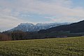
(South) West side of the mountain of Bischofswiesen seen
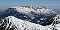
South side of the Untersberg massif, seen from the Fagstein
Untersberg, seen from Hellbrunn
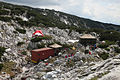
Tent city during the rescue operation in the giant thing shaft cave


literature
Monographs , articles:
- Wilhelm Erben : Untersberg studies. A contribution to the history of the German imperial saga. In: Mitteilungen der Gesellschaft für Salzburger Landeskunde , born in 1914, (Volume LIV), pp. 1–96. (Online at ANNO ).
- Eberhard Fugger : The Untersberg. Scientific observations and studies. In: Journal of the German Alpine Association / Journal of the German and (the) Austrian Alpine Association , year 1880, (Volume XI), pp. 117–197. (Online at ANNO ). .
- Eberhard Fugger, Karl Kastner: From the northern slope of the Untersberg. In: Mitteilungen der Gesellschaft für Salzburger Landeskunde , year 1886, (Volume XXVI), pp. 338–351. (Online at ANNO ).
- Eberhard Fugger: Observations in the ice caves of the Untersberg near Salzburg. In: Mitteilungen der Gesellschaft für Salzburger Landeskunde , year 1888, (Volume XXVIII), pp. 65–164. (Online at ANNO ). .
- Eberhard Fugger: The Salzburg plain and the Untersberg. In yearbook of the quays. Kings Geologische Reichs-Anstalt 1907, Issue 3, pp. 455-538.
- A. St .: The Untersberg. In: Der Naturfreund , born 1915, Volume XIX, pp. 11-13. (Online at ANNO ). .
- Walter Strobl: The forest associations of the Salzburg Untersberg area between Königsseeache and Saalach. In: Stapfia. (Publication of the Botanical Working Group at the Upper Austrian State Museum Linz), No. 21, Linz, June 23, 1989, PDF (8.2 MB) on ZOBODAT
- Adolf Steinhauser: An opinion on the name "Untersberg". In: Mitteilungen der Gesellschaft für Salzburger Landeskunde , year 1860, (Volume I, 1860/61), pp. 59–63 (hand- paged ). (Online at ANNO ). .
- Zillner ( ie Franz Valentin Zillner ): The Untersberg legends. In addition to an outline of the saga in general. In: Mitteilungen der Gesellschaft für Salzburger Landeskunde , year 1860, (Volume I, 1860/61), pp. 81–146. (Online at ANNO ). .
- Romance and industry at the Kyffhäuser in the Alps . In: The Gazebo . Volume 5, 1867, pp. 73, 76-79 ( full text [ Wikisource ]).
Maps:
- Berchtesgadener Land - Salzburg Limestone Alps . (Scale 1: 100,000). Freytag & Berndt Canoeing Maps, Volume 10. Freytag-Berndt and Artaria, Vienna 1979, ISBN 3-85084-810-8 .
- Untersberg, Eisriesenwelt, Königssee. Hiking, cycling and ski touring maps with GPS data [as well as] skiing and cross-country skiing routes . (Scale 1: 50,000). Edition: Duration 10/2003. Freytag - & - Berndt-WK, map 102. Freytag-Berndt and Artaria, Vienna 2000, ISBN 3-85084-705-5 .
- Berchtesgaden, Untersberg . (Scale 1: 25,000). 2nd edition 2013. Alpine Club Map Bavarian Alps, map BY 22nd German Alpine Club , Munich 2013, ISBN 978-3-937530-26-0 .
Myths:
- Rainer Limpöck : Untersberg myth . Vienna 2011, ISBN 978-3-85431-577-3 .
Web links
- Untersbergbahn , on unterbergbahn.at
References and comments
- ↑ a b Landscape profile - 1600 Berchtesgaden Alps . bfn.de, Federal Agency for Nature Conservation , last change: March 1, 2012.
- ↑ For the " geomorphological unit of Berchtesgaden valley basin" see Planning Office Steinert, Landschafts + Ortsplanung (D-83236 Übersee): Markt Berchtesgaden - Land use plan with landscape planning (PDF) Chapter: 2.6 Protected landscape ; Environmental reports from March 6, 2014 to March 6, 2016, PDF-S. 16 of 48 pages; In addition, multiple use of the terms “valley basin” and “valley basin communities” from p. 3, online at gemeinde.berchtesgaden.de
- ↑ Bavaria Atlas of the Bavarian State Government ( notes )
- ^ Austrian Map online , Federal Office for Metrology and Surveying (BEV), at amap.at
- ↑ a b Information about the quarries on Untersberg , on unterbergmuseum.net
- ^ OBV: Die Höhle : magazine for karst and cave science; Journal of the Association of Austrian Cave Researchers and the Association of German Cave and Karst Researchers e. V., 57th year, issue 1–4. Association of Austrian Speleologists, Vienna 2006
- ↑ Thilo Müller, Andreas Wolf: List of the longest and deepest caves in Germany. Working group Höhle & Karst Grabenstetten e. V., July 2016, accessed February 15, 2017 .
- ↑ Speleology. New giant cave discovered in Untersberg . In: salzburg.orf.at , December 23, 2009, accessed on November 22, 2010.
- ↑ Ulrich Meyer, Thomas Matthalm: The giant thing shaft cave in Untersberg . In: Messages from the Association of German Cave and Karst Researchers e. V. Band 57 , no. 2 , May 23, 2011, ISSN 0505-2211 , p. 36–44 ( vdhk.de [PDF; 2.6 MB ; accessed on October 25, 2012]).
- ↑ Ulrich Meyer: In search of the Barbarossa system in the Untersberg . In: Files of the 13th National Speleological Congress, 2012 - Actes du 13e Congrès national de Spéléologie . Muotathal 2012, p. 68–74 ( agsr.ch [PDF; 462 kB ; accessed on August 14, 2014]).
- ↑ JKM ( ie Karl Josef Mayr): The oldest occurrence of the name Untersberg. (Addendum). In: Mitteilungen der Gesellschaft für Salzburger Landeskunde , born in 1922, (Volume LXII), pp. 51–52. (Online at ANNO ).
- ↑ below, m. (f., n.) . In: Jacob Grimm , Wilhelm Grimm (Hrsg.): German dictionary . 16 volumes in 32 sub-volumes, 1854–1960. S. Hirzel, Leipzig ( woerterbuchnetz.de ).
- ↑ Hannes Scheutz (Ed.): Drent and herent. Dialects in the Salzburg-Bavarian border area . EuRegio Salzburg - Berchtesgadener Land - Traunstein, Freilassing 2007, OBV , DNB .
- ^ Johann Andreas Schmeller: Bavarian Dictionary . 2 volumes in 4 parts. (Special edition, reprint of the 2nd edition edited by G. Karl Frommann, Munich 1872–1877). Volume 1.1. Oldenbourg, Munich 1985, ISBN 3-486-52602-2 , OBV , column 116.
- ↑ Untersberg landscape protection area in the nature reserve book of the State of Salzburg
- ↑ Untersberg plant protection area in the nature reserve book of the State of Salzburg
- ↑ Untersberg Nature Park in the nature reserve book of the State of Salzburg
-
↑ Landscape protection area Untersberg-Vorland in the nature protection book of the State of Salzburg Untersberg-Vorland - European Protection Area Ordinance, Untersberg. Landscape Protection Ordinance 1981, Plant Species Protection Ordinance . (PDF; 74.3 kB) Sbg LGBl 2007/59, on ris.bka .gv.at
- ^ Thomas Grüner: Bavarian Alps. Nature - plants - animals: with walks and tips for exploring . Rother, 2012, ISBN 978-3-7633-3046-1 , pp. 86 ( limited preview in Google Book search).
- ^ Dopplersteig opened on June 13, 1876 after construction began in 1874. - see: Salzburg. In: Journal of the German Alpine Association / Journal of the German and (the) Austrian Alpine Association , year 1894, (Volume XXV), p. 428. (Online at ANNO ).
- ↑ Information on the Hochthron via ferrata , at stoehrhaus.de
- ↑ A. St .: The Untersberg , p. 13.
- ↑ Untersbergbahn , on salzburg.info
- ↑ Untersbergbahn . In: Salzburger Nachrichten : Salzburgwiki .
- ↑ Crashed by cable car: Worker seriously injured orf.at, October 25, 2017, accessed October 25, 2017.
- ↑ New gondolas for Untersbergbahn orf.at, November 28, 2018, accessed December 16, 2018.
- ↑ Untersberg Museum with ball mill. unterbergmuseum.net
- ↑ a b c Emperor Karl in Untersberg . Variant of the legend of Emperor Karl, on haben.at
- ↑ a b Maria E. Dorninger: Mythical end times. The Untersberg and medieval prophecy literature (PDF; 191.6 kB) p. 3 f. (10 pages), on uni-salzburg.at
- ↑ The wild hunt from Untersberg . In: Salzburger Nachrichten : Salzburgwiki .
- ↑ Johannes Lang : Lazarus Gitschner in Untersberg - The miraculous experiences of a Reichenhall city clerk assistant . In: History of Bad Reichenhall . 1st edition. Schmidt, Neustadt an der Aisch 2009, ISBN 978-3-87707-759-7 , pp. 312-325. - Table of contents. DNB
- ↑ Time travel at Untersberg on YouTube , August 17, 2016
- ↑ The time traveler from Untersberg. In: mein district.at. Regionalmedien Austria, March 14, 2012, accessed on August 17, 2016 .
- ↑ Time travel anomalies on the Untersberg: a German Bermuda Triangle? In: Grenzwissenschaftler.com. March 15, 2015, accessed August 17, 2016 .
- ↑ OBV , as ISBN is not unique.

City center: Festungsberg (with Nonnberg ) | Kapuzinerberg (with Bürglstein ) | Mönchsberg (with Rainberg )
Further urban area: Lieferinger Hügel | Hellbrunn Mountain | Morzger Hill | Nussdorf Hill
City frame: Gaisberg (with Kühberg , Rauchbühel ) | Heuberg | Millstone | Plainberg | Söllheimerberg | Untersberg