
Lieferinger Hills
| Lieferinger Hügel, Grafenhügel, Franzosenhügel | ||
|---|---|---|
 Lieferinger Hills |
||
| height | 434 m above sea level A. | |
| location | Salzburg , Austria | |
| Coordinates | 47 ° 49 '26 " N , 13 ° 0' 27" E | |
|
||
| rock | gray marl, marl limestone, sandstones, fucoids (Chondrites inlricatus Brongn. and Ch. Targionii Brogn.) and coal splinters. | |
| Age of the rock | Upper Chalk | |
| particularities | Flysch zone , remainder of the denuded cross bar of the Salzach Valley | |

The Lieferinger Hügel , also called Grafenhügel , Bühel von Liefering , Franzosenhügel or Franzosenschanze , is the highest elevation in the Liefering district of the city of Salzburg . The only 12 m high hill has an area of 5.6 hectares and is located southwest of the Lieferingen parish church. From a geological point of view, it consists of cement marl or marl limestone and sandstone. To the north, the hill continues after a slight depression in another elevation, only 1 meter lower at the highest point, which is locally referred to as Brandlbichl or Brandlbühel and on which, among other things, the church with the surrounding cemetery stands.
History, topography and buildings
The name "Grafenhügel" is derived from a field name. The fields there belonged to the Lechner or Grafengut, which was owned by the Counts of Arco from 1727 to 1792 . The Lechnergut was later renamed “Baldehof” or “Grafengut”. The farm remained an agricultural operation for 300 years. In 1889 it was acquired by the Congregation of the Sisters of Mercy . It has been used as the vicarage of the old Liefering parish since 1993 and as a supraregional parish center since 2000. Today the name “Am Grafenhügel” is only the address of two houses on a short stretch of road that branches off to the left from Törringstrasse immediately before the private access to the Franzosenhügel. This also gives rise to a connection to the Counts of Törring , the long-time treasurers of the Archbishopric of Salzburg, based in the Hofmark Törring, north of Lake Waginger . The Baillou Villa is also located on the Grafenhügel.
During the National Socialist rule, the Grafenhügel camp existed at Lieferinger Hügel , a camp for forced laborers who were used in the construction of the Rott an der Saalach power station, which is some distance away, and the nearest railway line.

The designation "Franzosenhügel" is also a field name and is reminiscent of the battle on Walserfeld from December 12th to 14th, 1800. The artillery positions of the Austrian army were located on the rock-cut hill in a south-western arc up to the Kleßheimer Schlosspark ; also here was the redoubt (Feldherrnhügel) of the Austrian troops. At the battle of the Walserfeld between Austria and the Napoleonic troops, the Count Hill in Liefering was also fiercely contested. Today the Brandelbühel children's playground is located here. The terrain is used as a ramp for a hill slide and a toboggan run.
In 1816, according to oral tradition, a resident of Liefering of unknown name found money in a dilapidated trench on the Franzosenhügel, which had probably been buried there by refugees. He used the amount of money found to buy the land from the Leopachergut and to build a house; Today it has become the Gasthof Kohlpeter, located some distance away.
- Törringstrasse

The Lieferinger Hügel is bounded on three sides by the Törringstrasse, which rises a few meters in the north and leads over the slight depression that connects the Lieferinger Hügel and the neighboring hill with the Lieferinger Church. In the east, a few meters away from the hill, are the western autobahn (A1) and the western part of its subterranean tunnel ( Lieferinger Tunnel , built in 2001, since 2004 with the tunnel playground above ) and Lieferinger Hauptstrasse.
At the beginning of Törringstrasse on the north side is the Fischerbrunnen . The fountain was created by the Lieferingen fishing guild in 1919 and rebuilt in 1952 after it fell victim to the construction of the autobahn in 1938. In 1973 it was rebuilt and moved to its current location at the beginning of the joint ascent to the Lieferinger hill and the hill of the Lieferinger church.
Not far from the fountain after the entrance to the cemetery is the Peter Pfenninger House, the club house of the Lieferinger fishermen, which operated as Pfaffenhäusl or Wörndlgut until it was acquired by the traditional association in 1959 . The house was rebuilt in 1975 and expanded in 1990. Today it also serves as accommodation for other traditional associations. The facade is decorated with a picture by the Salzburg painter Wilhelm Kaufmann .

The Lieferinger hill in winter
Fishing fountain

Peter Pfenninger House

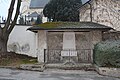
Roman grave relief


The Liefering elementary school is located next to the Peter Pfenninger House in the direction of the hill, with a wall painting by Wilhelm-Kaufmann on the facade.
Next to the fisherman's house on Törringstrasse is a cast of part of a Roman grave relief from the 3rd century AD, which was found in the nearest parish church in 1979. The original of the so-called Roman stone is in the Salzburg Museum . The relief shows "a team of oxen with Cupid, including two Cupid figures during the grape harvest".
The southern slope of the Lieferinger Hill along Törringstrasse and the meadows in front of it up to the Salzburg-Rosenheim railway line with the nearby Salzburg Liefering S-Bahn station are designated by the State of Salzburg as a conservation area that should not be entered by the general public.
literature
- Kurt A. Mitterer: Salzburg anno 1800. The forgotten battle on the Walser fields , Milizverlag Salzburg, Salzburg 1999, pp. 66–70. ISBN 3-901185-18-6 .
- Kurt A. Mitterer: The Lieferinger Franzosenhügel - the battle in front of Salzburg in 1800. In: Association District Museum Salzburg-Liefering (Hrsg.): The Lieferinger Kultur-Wanderweg - At 52 stations through the eventful history of a Salzburg district , Salzburg 2006, p 150-155.
Web links
Individual evidence
- ↑ According to the Geographical Information System of the State of Salzburg ( SAGIS ( Memento of the original from February 17, 2014 in the Internet Archive ) Info: The archive link has been inserted automatically and has not yet been checked. Please check the original and archive link according to the instructions and then remove this note. ) the height 434 m and the difference in height to the road at the southern slope foot 12 m.
- ^ Siegmund Prey: Explanatory description of the northern part of the geological map of the area around the city of Salzburg, 1: 50,000. - Flysch zone, Walserberg series, Gosau in the northern edge of the Limestone Alps and Quaternary ; S 303; online at geologie.ac.at (PDF; 2.2 MB), accessed on October 7, 2012.
- ↑ Eberhard Fugger: Die Salzburger Ebene and the Untersberg , p. 461, online at geologie.ac.at (PDF; 4.4 MB), accessed on October 7, 2012.
- ^ Geographical Information System of the State of Salzburg (SAGIS).
- ↑ Information board for the Lieferinger Kulturwanderweg on Törringstrasse.
- ↑ Playgrounds in Liefering ( Memento of the original from August 8, 2013 in the Internet Archive ) Info: The archive link was inserted automatically and has not yet been checked. Please check the original and archive link according to the instructions and then remove this notice. , accessed March 7, 2014.
- ↑ Hauschronik Kohlpeter ( Memento of the original from March 15, 2015 in the Internet Archive ) Info: The archive link was inserted automatically and has not yet been checked. Please check the original and archive link according to the instructions and then remove this notice. (PDF; 25 kB), accessed on October 7, 2012.
- ↑ Playgrounds in Liefering ( Memento of the original from March 7, 2014 in the Internet Archive ) Info: The archive link was inserted automatically and has not yet been checked. Please check the original and archive link according to the instructions and then remove this notice. , accessed March 7, 2014.
- ^ Peter Pfenninger donation: The Lieferinger Fischerbrunnen , accessed on March 7, 2014.
- ↑ Peter Pfenninger donation: The Lieferinger Fischerhaus , accessed on March 7, 2014.
- ↑ Peter Pfenninger donation: The Roman stone from the Lieferingen Church , accessed on March 7, 2014.
- ^ Table on the Römerstein.
- ↑ Official board on Törringstrasse.

City center: Festungsberg (with Nonnberg ) | Kapuzinerberg (with Bürglstein ) | Mönchsberg (with Rainberg )
Further urban area: Lieferinger Hügel | Hellbrunn Mountain | Morzger Hill | Nussdorf Hill
City frame: Gaisberg (with Kühberg , Rauchbühel ) | Heuberg | Millstone | Plainberg | Söllheimerberg | Untersberg