
Gaisberg (Salzburg)
| Gaisberg | ||
|---|---|---|
 Gaisberg from the bank of the Leopoldskroner Weiher |
||
| height | 1287 m above sea level A. | |
| location | Salzburg , Austria | |
| Mountains | Osterhorn Group , Salzkammergut Mountains | |
| Dominance | 5.7 km → Schwarzenberg | |
| Notch height | 592 m ↓ Hinterschroffenau | |
| Coordinates | 47 ° 48 '18 " N , 13 ° 6' 43" E | |
|
||
| Development |
Gaisbergbahn (1887–1929) Gaisbergstrasse (since 1928) |
|
| particularities | Gaisberg transmitter | |

The Gaisberg with a height of 1287 m above sea level. A. is one of the local mountains of the Austrian capital Salzburg . The Gaisberg transmitter is located at the top . The mountain , which belongs to the Salzkammergut Mountains, is also important today as a destination for excursions.
geography
The Gaisberg is a branch of the Osterhorn group and borders the Salzburg Basin in the east. Due to its location and easy accessibility, it is one of the most important local recreation areas in Salzburg and a very good vantage point over the city and the Berchtesgaden Alps . The western flank forms the Salzburg landscape (district) Gaisberg . The foothills of the Gaisberg protruding into the settlement area of the city of Salzburg between the districts of Parsch and Gnigl (Obergnigl) is the Kühberg . Another northeast situated streamers with a rocky peak is to the municipality Koppl belonging Nockstein , the southern train partially in the community Elsbethen lying Rauchenbühel ( 988 m above sea level. A. ). A small part of the Gaisberg in the western escarpments below the summit plateau is protected as the Gaisberg natural forest reserve .
Development
This leisure area was opened up early on and has been a popular hiking destination since the 18th century. As early as 1887, the mountain was made accessible by a cogwheel railway , the Gaisbergbahn , the valley station of which was in the Parsch district of Salzburg. She ceased her service in 1928 and was sacrificed to the road to Gaisberg that was opened in 1929.
In recent years, on beautiful summer days, Gaisbergstrasse has been closed again and again due to traffic congestion and the associated increase in air pollution. For this reason, among other things, the rebuilding of the Gaisbergbahn and the blocking of the road for cars have recently been discussed, but have not yet been implemented. In October 2009, the authorities began to reduce the number of parking spaces on the summit plateau to the approved number of 55 in order to curb individual traffic.
The Gaisbergspitze can currently be reached by public transport with the 151 bus , which runs several times a day from Mirabellplatz via Gnigl to the Gaisberg plateau.

Historic picture (approx. 1900): Gaisberg from the west
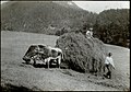
Haymaking on the Gaisberg, 1903

The Judenalpe station of the Gaisbergbahn (picture postcard from 1912)


.jpg)
There are numerous hiking trails on the Gaisberg. Three Austrian long-distance hiking trails run over the summit: the Voralpenweg , the Rupertiweg and the Salzburg Mariazellerweg . The long-distance hiking stone, a monument dedicated to Carl Hermann , draws attention to these paths on the summit plateau.
In winter, some of the hiking trails are groomed as cross-country trails. Tourers have also rediscovered the mountain. In summer, cyclists in particular use the Gaisberg as a training route. All year round you can see numerous paragliders and hang-gliders gliding around the Gaisbergspitze in good weather , which can take off from three take-off points just below the summit and then land on a meadow in the Salzburg district of Aigen .
From 1923 to the mid-1950s, there was a ski jumping hill near the Mitteregg-Alm. On March 20, 1949, Paul Ausserleitner won the Zistel jumping on Gaisberg in front of 10,000 spectators with a hill record of 55 meters. Even today you can still dare to jump over the hill on a ski tour over the so-called northern aisle .
On December 20, 1956, with the commissioning of the television station on the Gaisberg plateau , nationwide radio reception in the greater Salzburg area was made possible for the first time. Even today, the transmission system is characteristic of the appearance of the Gaisberg.
From 1929 to 1968, international motorcycle and automobile races took place on Gaisbergstrasse . Every year since 2002 there has been a racing event for historic automobiles to commemorate this. Also since 2002, a cycle race has been held on the 8.6-kilometer Gaisbergstrasse in preparation for the Tour of Austria . In 2009 and 2011, the Gaisberg summit was the first turning point and starting point for the first paragliding flight stage in the Red Bull X-Alps competition.

Gaisberg transmitter

A Riley Sprite racing car at the 2006 Gaisbergrennen

In addition to the restaurants on the Mitteregg, the Gersbergalm and the Zistelalm, the traditional luxury hotel Kobenzl is located on the Judenbergalpe , which should have reopened as a five-star-plus hotel in the first half of 2012 after its closure in autumn 2006. From January 2015, refugee quarters were set up in Kobenzl.
outlook
The Gaisberg is also a popular destination for the local population. At the level of the Zistelalm there is a circular hiking trail with views and, especially from the top, extensive views of the Alpine foothills .


literature
- Geisberg. (...) . In: Franz Michael Vierthaler : Travels through Salzburg . Mayr, Salzburg 1799, p. 27 ff. - Text online .
- Franz Martin : The Gaisberg through the centuries. (1923). In: Mitteilungen der Gesellschaft für Salzburger Landeskunde , year 1942, pp. 1–10 (supplement main part). (Online at ANNO ). .
- Bernhard Paumgartner : View from Gaisberg near Salzburg. A small piece of Austrian cultural history . Bundesverlag, Vienna. 1936. - Full text online (PDF; 225 kB) .
- Friedrich Leitich, Guido Müller : The Gaisberg. Salzburg's local mountain in the current events of two centuries . Communications from the Society for Salzburg Regional Studies, Supplementary Volume 16, ZDB -ID 507477-0 . Self-published by the Society for Salzburg Regional Studies, Salzburg 1997.
Web links
- www.salzburg.com/wiki/index.php/Gaisberg , pictures and information about the Gaisberg on Salzburg WIKI
- www.gaisberg.at , further links to events, initiatives and gastronomy on the Gaisberg, live picture from the Gaisbergspitze
- Gaisberg . In: Salzburger Nachrichten : Salzburgwiki .
Individual evidence
- ^ Report from ORF Salzburg online from October 5, 2009 about the measures on the summit car park
- ↑ 1. Hang gliding and paragliding club Salzburg
- ↑ Mitteregg-Schanze / Zistelschanze. Retrieved September 6, 2014 .
- ^ Hotel Kobenzl Betriebs GmbH: Dear visitor, (...) . In: hotel-kobenzl.at , accessed on January 14, 2013.
- ↑ Asylum Center: A new chapter in Kobenzl begins immediately. In: Salzburger Nachrichten of January 30, 2015, accessed on March 19, 2015
_COA.svg)
Districts: Aigen | ( Old Town (left) | Old Town (right) | Elisabeth-Vorstadt | Gneiss | Gneiss South | Gnigl | Itzling | Schlachthofsiedlung | Kasern | Langwied | Lehen | Leopoldskron-Moos | Liefering | Maxglan | Kendlersiedlung | Morzg | Mülln | Neustadt | Nonntal | Parsch | Riedenburg | Salzburg-Süd | Schallmoos | Taxham . Landscapes: Hellbrunn | Gaisberg | Heuberg

City center: Festungsberg (with Nonnberg ) | Kapuzinerberg (with Bürglstein ) | Mönchsberg (with Rainberg )
Further urban area: Lieferinger Hügel | Hellbrunn Mountain | Morzger Hill | Nussdorf Hill
City frame: Gaisberg (with Kühberg , Rauchbühel ) | Heuberg | Millstone | Plainberg | Söllheimerberg | Untersberg