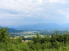
Salzburg basin
Coordinates: 47 ° 56 ′ 44 ″ N , 12 ° 59 ′ 40 ″ E

The Salzburg Basin , also known as Salzburg-Freilassing Basin , is a rim-alpine basin in the Flachgau in the Austrian state of Salzburg and in the bordering areas of Bavaria . Here lies one of the largest cities in the Alps with the provincial capital Salzburg . The basin belongs to the valley of the Salzach .
Landscape and boundaries
The Salzburg Basin has an elongated north-south shape and extends in the north to Oberndorf and Laufen and in the south to Golling. Besides Salzburg, important cities are Hallein, Freilassing, Laufen and Oberndorf. The Salzburg Basin is bounded in the east by the Osterhorn group with Schmittenstein (1695 m) and Gaisberg (1287 m), in the north-west by moraine walls, in the south by the Untersberg massif , by the Hohen Göll as well as by the Tennen and Hagen mountains, and in the West again through terminal moraine walls and the Staufen .
The river valleys of the Salzach and Saalach as well as the Fischach , the Almbach and the Königsseeache come together in the basin . Inselbergs in the Salzburg Basin are the Kapuzinerberg , Mönchsberg , Rainberg and Hellbrunner Berg .
The "Hallein Basin" is usually added to the Salzburg Basin, but it is not an independent basin. The Salzburg basin is one of the most densely populated ridge alpine basins .
geology
The Salzburg Basin is a landscape formed during the Mindel-Riss interglacial and the Riss-Würm interglacial , i.e. in warm periods between the respective ice ages . During the warm periods in the geological period of the Pleistocene , the loose material was cleared out by the melting of the ice in the Salzburg Basin ( Salzach Glacier ), although some structures in the basin were also created by tectonic activity. Both in the warm periods and in the post-glacial period, a lake stretched a maximum of 30 kilometers in length and 10 km in width after the glacial period, in which mighty banks such as the Salzburg mountains Kapuzinerberg, Mönchsberg, Rainberg and Hellbrunner Berg, consisting of the Nagelfluh conglomerate, were deposited were. Later gravel banks were built that rest on the lake clay . Its thickness is 100 to 150 meters, in the Oichtental even 250 meters.

The separation of the entire Salzburg – Hallein basin into the northern part and the Hallein basin in the south is also due to the geological environment. The latter is still entirely in the Northern Limestone Alps , on the border of which the Oberalmer strata lie east of the basin complex and the Roßfeld formation to the west . The Salzburg Basin, on the other hand, lies almost entirely in the flysch zone ( Rhenodanubian flysch ) and ends in the north at Burghausen / Laufen with the Laufener Salzach valley , the breakthrough valley through the foreland molasse and worm-age sediment banks (ground and end moraines of the last major advance).
Individual evidence
- ^ Rare, modern term in the EuRegio Salzburg - Berchtesgadener Land - Traunstein (the Salzburg basin has included Bavarian parts since 1816). so with Karin Lorenzato: Salzburger Land: From Salzburg to the Großglockner , 2009, p. 15
- ^ Greater Salzburg landscape, after Erich Seefeldner: Salzburg and its landscapes: a geographical study of the country . Society for Salzburg Regional Studies, 1961.
-
↑ Bavarian natural space unit 901.0 / 039.0, according to various authors: Geographical land survey: The natural space units in single sheets 1: 200,000 . Federal Institute for Regional Studies, Bad Godesberg 1952–1994:
Sheet 182/183: Burghausen (Peter Weichhart 1979) → online map (PDF, 6.2 MB);
Sheet 190/196: Salzburg (Klaus Hormann 1978) → online map (PDF, 6.3 MB) - ↑ Austria Lexicon
- ^ Paul Dorn : Geology of Central Europe , Stuttgart 1966, p. 381
