Fischach (Salzach)
| Fischach | ||
|
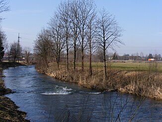
The Fischach in Bergheim |
||
| Data | ||
| location | Salzburg , Austria | |
| River system | Danube | |
| Drain over | Salzach → Inn → Danube → Black Sea | |
| source |
Wallersee in Fischtaging (cadastral community Seewalchen, Seekirchen am Wallersee ) 47 ° 54 ′ 11 ″ N , 13 ° 8 ′ 44 ″ E |
|
| Source height | 505 m above sea level A. | |
| muzzle |
Salzach bei Muntigl ( Bergheim ) Coordinates: 47 ° 51 '1 " N , 13 ° 0' 25" E 47 ° 51 '1 " N , 13 ° 0' 25" E
|
|
| length | 15.5 km | |
| Discharge at the Lengfelden A Eo gauge : 159.4 km² Location: 3.78 km above the mouth |
NNQ (02/04/1987) MNQ 1976–2011 MQ 1976–2011 Mq 1976–2011 MHQ 1976–2011 HHQ (08/06/2002) |
70 l / s 1.22 m³ / s 4.39 m³ / s 27.5 l / (s km²) 63 m³ / s 165 m³ / s |
| Left tributaries | Eugenbach | |
| Small towns | Seekirchen am Wallersee | |
| Communities | Hallwang , Eugendorf (municipality boundary ), Elixhausen (municipality boundary ), Bergheim (Lengfelden, Fischach) | |
The Fischach is a 15 km long right tributary of the Salzach in the north of the Austrian state of Salzburg .
course
The Fischach has its origin at the western end of the Wallersee in the urban area of Seekirchen am Wallersee , where it has its starting point as the only outflow of the lake near the village of Fischtaging . The Fischach flows through the Flachgau in a south-westerly direction, and in the last section in a westerly direction. In its course it also forms the municipal boundaries between Seekirchen am Wallersee and Eugendorf and then between Hallwang and Elixhausen . As a result, the Fischach flows through the villages of Lengfelden and Fischach ( Bergheim municipality ), then forms the border between Bergheim and the city of Salzburg for a few hundred meters before it flows into the Salzach again in the Bergheim area, southwest of the village of Muntigl .
The Westbahn runs in parts in the Fischach valley .
Tributaries
The only noteworthy tributary is the Eugenbach, which flows from Schwöllern via Kraiwiesen and Eugenbach (all Eugendorf municipality) and drains this old moss and peat cut area. It flows into the Fischach near the hamlet of Mühlberg.
history
Well into the 20th century, the Fischach had numerous arms in the estuary, where it often flooded agricultural land during floods. In 1923 the Fischach water cooperative was founded to take measures to contain such damage. Initially, a series of punctual repair work was carried out, but this led to the overflow of the lower reaches and to bank invasions. Triggered by a devastating flood on July 8, 1954, which destroyed all bridges and large agricultural areas in the Bergheim area, comprehensive plans for regulation were subsequently drawn up. The work was finally completed in 1974. Most recently, the floods of December 1, 1988, August 2, 1991 and August 12, 2002 as well as July 13, 2005 made further remedial measures necessary.
Trivia
A Perchtenverein and a Hallwanger Heimatverein are named after the Fischach .
literature
- Johann Berger: The fish fish regulation. In: Municipality of Bergheim (ed.): Bergheim. Past and present , Bergheim 2009 (without ISBN)
Web links
Individual evidence
- ↑ Federal Ministry for Agriculture, Forestry, Environment and Water Management (Ed.): Hydrographisches Jahrbuch von Österreich 2011. 119th Volume. Vienna 2013, p. OG 136, PDF (12.9 MB) on bmlrt.gv.at (Yearbook 2011)

