
Fiefdom (Salzburg)

Lehen is a densely populated district in the north of the city of Salzburg . The district, roughly triangular in outline, is bounded in the south by a section of the Rosenheim – Salzburg railway line , in the northwest by Glanbach and Glankanal and in the east by the Salzach . Almost 15,000 residents live in fiefdoms, more than in any other part of Salzburg.
The district is characterized by old residential buildings and a relatively high proportion of migrants. To the south of Lehen, east of Rudolf-Biebl-Strasse, lies the old Salzburg suburb of Mülln , to the west of the same is the Maxglan district . The Liefering district connects to the north and west . In the east, the Salzach and its remains of alluvial forest form the border between the district and Itzling and Elisabeth-Vorstadt (Froschheim).
The main traffic routes are Ignaz-Harrer-Strasse and Rudolf-Biebl-Strasse, which are often congested during peak times.
history

The name of the district is derived either from the Middle High German lēhen 'fiefdom, property lent to a nobleman or free person '. or else (a noble estate is not known there before the 17th century) from the word Lohe or Löhen = (moist) forest, pasture forest. The core area of Lehen in the 19th century was the group of hamlets around Rauchmühle, Annahof and Lürzerhof . The old military shooting range, which was later relocated to Glanegg, was located south of today's Lehner Park to the current state vocational school, extending from around 1870 to after 1900. Schießstattstraße is a reminder of the earlier use of the landscape.
Until the city expansion of Salzburg and the associated incorporation of the former communities Maxglan and Gnigl / Itzling in 1935 and 1939, only the northern part to the right of the Glan Bach belonged to fiefdoms, the areas to the left partly to Maxglan. The northern area between the Glan piercing and the former city limits was again part of the community Gnigl / Itzling. Since fiefdoms were largely a floodplain of the Salzach and Glan, the district was sparsely populated until the 19th century. It was not until 1874 that the first construction work began in the area of today's Gaswerkgasse. In 1906 the systematic asphalting of the streets was tackled.
In 1902 Ignaz-Harrer-Straße, today the main artery of the district, was laid out. This street is named after the former Salzburg mayor and member of the state parliament Ignaz Harrer . It begins at the Lehener Brücke and connects the neighboring district of Froschheim or Elisabeth-Vorstadt with the Munich main road. The construction of residential and commercial buildings in the style of the late 19th century that began at the beginning of the 20th century can only be recognized today by a few intact objects. In the years from 1924 to 1930, social housing began also in the increasingly populous fiefdom and had a significant impact on the image of this district.
Geographical breakdown
Fiefdom South-West: The historical core
This part of Lehen is limited by Ignaz-Harrer-Straße in the north, the railway line in the south, as well as in the west by the Glankanal and in the east by Rudolf-Biebl-Straße.
The historic buildings are located in a spacious, three-part park area. The parks of Rauchmühle and O´Donell´schem Schloss (Lürzerhof) are separated by fences and walls and are not open to the public. The park of the O´Donell´schen Castle is followed by a spacious, freely accessible park area on which, among other things, children's playgrounds have been created. Notable buildings are:
- The "Fisslthalermühle"
- It can be traced back to the 14th century under the name Astmühle. Today the company located on the Glan is known as the “smoke mill”.
- The "Villa Rauchmühle"
- In 1897, the well-known master builder Jakob Ceconi built this villa, which is directly adjacent to the mill's factory building, for the Maxglaner citizen Franz Fisslthaler. The building in late historical style has interesting neo-baroque decorative elements, which are continued in the enclosure and the wrought iron gate. The villa used to belong to the Maxglan district , but is now part of the Lehen district due to its location north of the railway line.
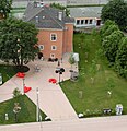
- The " Lürzerhof "

- This was first called "Egglgut am Gailinpach", but later also "O´Donellhof" or "O´Donell`sches Schloss" and is directly connected to the smoke mill complex. Its core dates back to the 17th century and has a slender tower in front of the east facade with a loggia on the 3rd floor including the wrought iron railing from the 17th century. The chapel of the former Lürzerhof has a baroque altar with a picture of Our Lady of Sorrows (mid-18th century). The building complex has been used as a special school for the hearing impaired since 1898.
Fief south
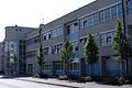
Lehen Süd is bounded by Ignaz Harrer-Strasse in the north, the railway line in the south, Rudolf-Biebl-Strasse in the west and the Salzach on the east side. This area includes the Christian-Doppler-Gymnasium and Realgymnasium and the old municipal works area, which was redesigned under the name Stadtwerk Lehen and, among other things, houses the Salzburger Bildungswerk and the Robert Jungk library for future issues. The Paracelsus Medical Private University is directly connected to this area or has a share in it.
- Eizenbergerhof
Right next to the university building there is a cultural gem - the "Eizenbergerhof" (formerly also "Maß-Hof" or "Mühlbacher Hof"). Built in the style of a typical manor with a wide beveled arched portal, the core of the building dates from before 1600 and was first mentioned around 1600. The unicorn head that was later attached here above the entrance portal, the groin vault on the ground floor, one during the renovation, are remarkable A stone column on the first floor that was exposed at the end of the 1980s, as well as baroque wooden coffered ceilings on the second floor, marble floors and some original doors. For fifteen years there was a fountain by Hilde Heger in the garden in front of the building , which is now in front of the Elisabeth Church .
The Eizenbergerhof served as an inn and Meierhof for 300 years. In 1904 the city of Salzburg acquired the building, which increasingly deteriorated as a military shelter and later as a residential building during the First World War. Listed as a historical monument, the oldest building in the Lehen district survived. In 1991 literature was settled here and the Salzburg House of Literature was founded. Several literary associations are now housed in the building. In 2003, at the suggestion of the literary house director Tomas Friedmann, the place in front of the Eizenbergerhof was named by Mayor Heinz Schaden after the deceased poet HC Artmann , who was closely connected to the literary house. In the course of the construction work on the former public utility area opposite, the square was redesigned and officially opened under this name on June 12, 2015. In front of the building there has been a so-called “book filling station” since 2012 - a telephone booth that is open day and night for exchanging used books.

Christian Doppler High School
Paracelsus Medical Private University
Literaturhaus and forecourt, H. C.-Artmann-Platz

Gallery Fotohof


Opposite the Literaturhaus - on Inge-Morath- Platz - the photography institution Fotohof, founded in 1981, has been located in a part of the newly built Lehen municipal utility since February 2012 . The rooms designed by the architects “transparadiso” are located on the ground floor of two connected residential buildings and house a gallery and one of the largest specialist libraries for contemporary photography in Austria, which is open to the public.
Fiefdom north
The northern part of Lehen is bordered by the so-called Glanspitz (confluence of Glankanal and Salzach) in the north, Ignaz-Harrer-Straße in the south, the Glankanal in the west and the Salzach in the east.
- Residential buildings and football stadium
The "Scherzhauserfeldsiedlung" was one of the first peripheral settlements of Lehens, which was built soon after the First World War on the northernmost edge of the then city, surrounded by wide meadows and fields. This settlement got its name from the farm of the same name, now built, which was also called "Gut am Gailenbach" after a tributary of the Glan. Starting in 1929, nine residential blocks were built in a row with a total of 34 small houses and a shared wash house. In 1931 two more apartment blocks were built and in 1939 another three groups of houses. Thomas Bernhard describes in his story Der Keller. A deprivation of his time as an apprentice with a grocer in this settlement.

The former so-called “Heeresbausiedlung” was built in 1940 to the south of this settlement for officers and NCOs of the German Wehrmacht . The streets there were named after flowers.
After 1955, "Groß-Lehen" was built as a new settlement between Roseggerstrasse and Schießstattstrasse under various builders (including the City of Salzburg).
Lehen also became famous for the Lehen stadium of the SV Austria Salzburg football club , which opened in 1971 and was the most modern football arena in Austria at the time. After the club moved to the EM stadium in Wals-Siezenheim , the stadium in Lehen was stopped. The stadium was demolished with the exception of a floodlight pole.

The so-called “Neue Mitte Lehen”, a district center, was built in place of the stadium. The stadium lawn was left and is now a green area. On both of its long sides, buildings were erected in such a way that the entire architectural ensemble is reminiscent of the old stadium with its grandstands. The building complex houses the Salzburg City Library , shops and apartments as well as a senior center. In the vicinity of the new building there are still a post office, a shopping market and various other, long-established shops. A kindergarten is also located in this area.

- Green spaces
The public green areas of this district are also located in Nord-Lehen:
- Lehener Park
- The Lehener Park emerged from an undeveloped patch of alluvial forest on the Salzach. Individual old forest trees of the once valuable black poplar alluvial forest have been preserved here as park trees. It is used for sports and leisure purposes.
- Glanspitz and Itzlinger Au (southern part)
- The Glanspitz to the north of the closed settlement area Lehen towards Liefering and Itzling connects the districts Liefering-Süd and Itzling as a recreational area.
- Vinzenz-Pallotti-Platz
- The small park in front of the parish church Vinzenz Pallotti in Lehen next to the former Lehen stadium is mainly used as a children's playground.
- Churches
- Parish church Salzburg-Lehen : After the Second World War, Lehen and its first chapel, St. Josef, were initially taken care of by the Müllner parish. It was initially housed in a former refugee barrack. Soon, however, the socially committed congregation of the Pallottines (with its seat in the Johannesschlössl on Mönchsberg) took over the pastoral work in fiefs. With their support, the Lehen Church was built from 1962 to 1964 and consecrated to its founder, Vinzenz Pallotti, who was then canonized . It is designed in the shape of a large tent, which was not uncommon at the time, and has huge tent roof surfaces on the inside , which are clad with Brazilian pine. It was inaugurated in 1965 by Archbishop Andreas Rohracher .

Church building

Bell tower

inner space


schools

Lie in the eastern part of fiefs
- two elementary schools
- the Neue Mittelschule Lehen with a focus on computer science and creative media design
- the Christian-Doppler-Gymnasium and Realgymnasium
- the evening high school in Salzburg
- the Josef Rehrl School , an integrative elementary and secondary school for children with hearing impairments
- the federal commercial academies 1 and 2 and
- the state vocational schools 1–4
Roads and traffic
- public transport

As part of the realization of the S-Bahn Salzburg project , Lehen received two S-Bahn stations, the Salzburg Mülln-Altstadt stop directly on the border with Mülln with access from Gaswerkgasse and the Salzachkai, and the Salzburg-Aiglhof stop above the Rudolf- Biebl Street. Lehen is well supplied with public transport by the trolleybus lines 1, 2, 4, 7 and 10 as well as the bus line 24 according to the high population density. In addition, the so-called Stieglbahn begins in Lehen, which is a connecting railway operated exclusively for freight traffic .
- Street names and their origins
Some streets are named in memory of the former possession of Salzburg in today's Carinthia: Althofen , Friesach and Hüttenberg . Arnsdorf in Lower Austria , as the former Salzburg center of local wine-growing, gave its name to Arnsdorfgasse .
The Kreuzbrünndlgasse was built in 1939 after the Kreuzbrünndlgasse in the Gaswerkgasse was demolished to solve a traffic problem. (The Kreuzbrünndl there was reminiscent of an old Weichbildkreuz that marked the boundary of city law in the late Middle Ages.) Kuenburgstrasse is named after the Kuenburg family. who came from three Salzburg archbishops in the 16th and 17th centuries. Regensburgstrasse is also based on a religious past, as the diocese of Regensburg was Salzburg's church province from 798 to 1818. The Siebenstädterstrasse commemorates the seven cities in the archbishopric for which Johann Ernst Graf Thun set up the “Siebenstädter Stipendium” in 1702.
Streets were also named after flowers, the Rosengasse , the Liliengasse , the Nelkenstrasse and the Tulpenstrasse .
People after whom streets and squares are named in fiefdoms:

- Karl Adrian , founder of the Volkskundemuseum Salzburg
- William H. Arnold , commander of the US occupation after World War II
- HC Artmann , Austrian poet, co-founder of the Salzburg literary house
- Anton Behacker , Councilor and State School Inspector
- Adolf Bekk , director of the Salzburg teacher training institute and poet
- Thomas Bernhard , Austrian writer
- Rudolf Biebl , Mayor of Salzburg
- Johann Brunauer , member of the state parliament and vice-president of the Chamber of Labor

- Christian Doppler , Salzburg physicist
- Wilhelm Erben , Salzburg historian
- Luise Esshaver , writer, donated her fortune for charity
- Leonhard von Keutschach , Prince Archbishop of Salzburg (1495–1519)
- Nikolaus Lenau , Austrian writer
- Ignaz Harrer , Mayor of Salzburg
- Joachim Haspinger , Tyrolean freedom fighter and Capuchin priest
- Franz Martin , Salzburg historian
- Vincent Pallotti , Italian priest and founder of an association of believers
- Hans Paumann , founder of the first printing house in Salzburg (1548)
- Georg Pichler , Salzburg historian
- Peter Rosegger , Austrian writer
- Hans Sachs , Nuremberg Mastersinger, wrote a song of praise for Salzburg
- Albert Schumacher , Mayor and Governor of Salzburg
- Alois Stockinger , large landowner in the Lehen district, promoted its development
- Josef Struber and Anton Wallner , leaders in the uprising against the French occupation forces (1809)
literature
- prolit - Association for the Promotion of Literature, Association Spectrum (Hrsg.): von Lehen. In the middle of the district. Edition Eizenbergerhof, Salzburg 2009, ISBN 978-3-901243-31-8 .
- prolit - Association for the Promotion of Literature, Association Spectrum (Hrsg.): von Lehen 2. Around the Stadtwerk. Edition Eizenbergerhof, Salzburg 2011, ISBN 978-3-901243-36-3 .
Web links
Individual evidence
- ↑ Ingo Reiffenstein and Thomas Lindner: Historical-Etymological Lexicon of Salzburg Place Names (HELSON) . Volume 1 - City of Salzburg and Flachgau, Edition Tandem, Salzburg 2015 [= 32nd supplementary volume to the communications of the Society for Salzburg Regional Studies ], ISBN 978-3-902932-30-3 , p. 73.
_COA.svg)
Districts: Aigen | ( Old Town (left) | Old Town (right) | Elisabeth-Vorstadt | Gneiss | Gneiss South | Gnigl | Itzling | Schlachthofsiedlung | Kasern | Langwied | Lehen | Leopoldskron-Moos | Liefering | Maxglan | Kendlersiedlung | Morzg | Mülln | Neustadt | Nonntal | Parsch | Riedenburg | Salzburg-Süd | Schallmoos | Taxham . Landscapes: Hellbrunn | Gaisberg | Heuberg
Coordinates: 47 ° 49 ' N , 13 ° 2' E