
Elisabeth suburb
|
Elisabethvorstadt ( district ) Salzburg district Elisabeth-Vorstadt |
|||
|---|---|---|---|
|
|||
| Basic data | |||
| Pole. District , state | Salzburg (city) (S), Salzburg | ||
| Judicial district | Salzburg | ||
| Pole. local community | Salzburg ( KG Salzburg , Itzling ) | ||
| Locality | Salzburg | ||
| Coordinates | 47 ° 48 '54 " N , 13 ° 2' 22" E | ||
| height | 417 m above sea level A. | ||
| Residents of the stat. An H. | 6057 (2001) | ||
| Building status | 421 (2001) | ||
| Post Code | 5020 Salzburg | ||
| prefix | + 43/0662 (Salzburg) | ||
| Statistical identification | |||
| Counting district / district | Elisabeth suburb; Itzling-West / Hagenau (50 101 44 [0-6], 38 [3]) | ||
| Plan of Elisabethvorstadt | |||

|
|||
 View over the cathedral district , Neustadt , Elisabeth-Vorstadt, Itzling towards Plainberg |
|||
| formerly Froschheim, Plainviertel ; Counting district differs from city district Source: STAT : Ortsverzeichnis ; BEV : GEONAM ; SAGIS |
|||

Elisabeth-Vorstadt (formerly Froschheim , sometimes also called Plainviertel ) is a district of the statutory city of Salzburg . It is located between the Salzach and Salzburg Central Station and is partly urban and partly characterized by residential villas.
geography
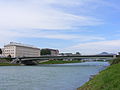
The Elizabeth suburb located north of the old town of Salzburg between the New Town and the historic village of Itzling . It is bounded in the west by the Salzach, in the north by Erzherzog-Eugen-Strasse and August-Gruber-Strasse , and in the east by the railway tracks of the main train station. The railway bridge over the Salzach forms the southern boundary .
The district with its 72.6 hectares forms a statistical census district of the city (44) , within boundaries that differ slightly from today's urban structure. Around 7,500 people live in Elisabeth-Vorstadt, and the district has around 500 buildings.
In today's city structure of Salzburg, the Elisabeth-Vorstadt is divided into two settlement areas:
- Froschheim (in the narrower sense) between Salzach and Plainstraße
- Elisabeth-Vorstadt (in the narrower sense) between Plainstrasse and railway facilities
Regardless of the blocks are next to the Hauptbahnhof railway station district called the local positions in the far south, on the border with New Town, pebbles (after the pebbles building ) and Gebirgsjägerplatz . Froschheim is characterized by loose villa complexes and a lot of green, the actual Elisabeth suburb and the locations close to the city have a highly urban character with apartment blocks, high-rise buildings and train station infrastructure.


View over the cathedral district , Neustadt , Elisabeth-Vorstadt, Itzling towards Plainberg

Wintry Salzachufer in Froschheim from feudal seen

- Neighboring districts and locations
|
Itzling (Stt.)
Austraßensiedlung ( Stt. Itzling) |
Itzling Mitte (Stt. Itzling) |
|
| Fief (Stt.) |
.svg)
|
Schallmoos (Stt.)
Schallmoos West (Stt. Gnigl) |
| Mülln * (Stt.) | Neustadt (Stt.) |
- *In one corner: Inner garbage
History and Buildings

The old part of Froschheim arose soon after the Salzach regulation and the beginning of the demolition of the Lodron town fortifications in 1861. The name of the present urban settlement area, which is understandable due to the frequent floods and the once numerous frogs, was formerly called Froschham. It comprised a group of small farming hamlets with Dreyergut, Patzengut, Dagghofergut and Helmreichgut . The name Froschheim appears as "Froscham" on the oldest survey plan of the city and its surroundings in 1789 (AFH Naumann, map of the high prince's residence city of Salzburg ... and the surrounding keep). A pilgrim from Froschheim seems to have been mentioned in a document as early as 1109. The narrow wooded edge there on the Salzach was formerly called Caspisau , the fields Caspisfelder , named after the Caspisschlössl of the Lords of Caspis , which was built in 1685, later also called Schöneck Castle and then Villa Haimerle and is now used as a rectory and kindergarten.
On the corner of Plainstrasse and Bayrisch-Platzl-Strasse is the Bayrische Platzl , which dates back to the 16th century and is an alleged sanctuary of ambassadors of the Bavarian dukes, where Bavaria could demand the extradition of criminals.

The street outside today's Westbahn to Bergheim and Maria Plain , today's Elisabethstraße , was called Froschheimer Hauptstraße until 1897 . An old pilgrimage route has been running on this since 1705, marked by the secret pillars on the way to the pilgrimage basilica there . Before the regulation in the years after 1860, the banks of the Salzach with the old Treppelweg extended roughly where Bergheimer Straße runs today . Today's Plainstrasse dates from around 1900.
The Westbahn ends at the main train station, and the railway line continues westwards via Salzburg-Taxham to Bavaria ( Rosenheim – Salzburg line ).
Next to the Salzach, north of the railway line, where the Gebirgsjägerplatz with its surrounding buildings stands today, the Salzburg slaughterhouse was built after 1860. The first street to be built on the Salzach between 1880 and 1900 was Stauffenstraße , a street with a view of Hohenstaufen , which has belonged to Bavaria since 1816 , and the first villas were built on. Further north, directly on the regulated Salzach, was the first location of the trotting track, which later moved several times. When the Ludwig-Victor-Brücke was built in 1902 on the site of today's Lehener Brücke , this settlement center experienced a further boom. Since 1977 there has been a second crossing from Froschheim to Lehen with the Pioniersteg .

After the construction of the railway facilities and the main train station, the name Froschheimer Hauptstraße was renamed Bürgerfeldstraße in 1901 and in 1904 Elisabethstraße in honor of Empress Elisabeth of Austria-Hungary (Sissi) . The initiators of this renaming were Mayor Franz Berger and the landowner and councilor Sylvester Oberberger . On July 15, 1901, the station forecourt was also given its Elisabeth monument - a statue that was covered in 1918 (collapse of the Austro-Hungarian monarchy ) and brought to Hellbrunn in 1924 , but returned to its original place in 2002. The district was renamed Froschheim again a short time after the First World War (obviously as a sign of the separation from monarchical models) . Today, however, the term is generally only used for the small-scale settlement area near the Salzach.
In the last years of the monarchy, this area was one of the most important urban expansion areas of Salzburg. Sylvester Oberberger developed the concept of a villa suburb based on his foundations. At the same time he campaigned for the renaming of Froschheim in Elisabeth-Vorstadt since 1898 . Next to the train station, the most important building in the district was for a long time the Hôtel de l'Europe with its extensive park. After the First World War, the development and development of the city was promoted and the development west of Haunspergstrasse, which still exists today, was built with apartment buildings and single-family houses, some of them in a style typical of the time and by students of well-known architects such as Peter Behrens . This zone of the district is now under ensemble protection, for some buildings there are maintenance requirements.

Today's parish church Salzburg-St. Elisabeth (European Church of Peace) existed as a smaller branch church in Froschheim von St. Andrä from 1931 and was looked after by Kalasantine fathers and from 1934 by Jesuit fathers. In 1938 St. Elisabeth became its own parish. A primary and secondary school is located next to St. Elisabeth's Church. The secondary school was built between 1930 and 1931 and was badly damaged by bombs in 1944.
The pebble building , now a shopping center and above it used by large office space, was originally a printing and publishing house ( Berglandbuch , Salzburger Volksblatt daily ) and was built in 1926 according to plans by Wunibald Deininger . The renovation from 1987 to 1989 was carried out by Wilhelm Holzbauer , whereby the landmarked, striking front of the building was retained. It is a listed building .
During the Second World War, the district was hit hard several times by the bombing of the main train station.
The new church, which was started before the war, was also badly damaged. 1953–1955 it was then rebuilt according to plans by Bruno Maria Apollonj Ghetti . The large, cellar-like room in the front of the church was planned as a lower church, but later served the Elisabeth stage as a popular venue for several decades . A planned church tower was not realized for cost reasons. In 1972 the Pestalozzi Elementary School was built.

The partial destruction of the Hôtel de l'Europe by aerial bombs and the subsequent demolition of the building also freed up space for the dense development east of Elisabethstrasse, in particular the residential complexes for postal workers around Südtiroler Platz . In 1953 the current Hotel Europa was built, with 15 floors the first and for a long time the highest high-rise in Salzburg. It was slightly changed during a renovation in the first years after 2000. In the 1970s, the Südtiroler Platz was redesigned again with the construction of the originally popular, but at times controversial forum complex with the Zyla towers and the house of the former federal state insurance company, today UNIQA . An adaptation and further expansion of the forum into an expanded shopping center was completed in 2011.
In 1955 the central heating power station was built. Initially a functional building, it was rebuilt in 1999-2003 after some renovations. Since it is located directly on the embankment of the Salzach, which can be seen from afar, and in the buffer zone of the UNESCO World Heritage Historic Center of the City of Salzburg , an attempt was made to minimize the city silhouette by designing it with black cubes (blocks and chimneys). Regardless of this, the building was criticized for its noticeably dark color and the lack of detail.

The station forecourt, the Südtiroler Platz, has been rebuilt several times. In 1988 the forecourt was completely redesigned as a hub for bus and trolleybus traffic. The local train station has been underground since 1996. From 2010 to 2014, the station building itself and the railway facilities were adapted to modern requirements. Here, too, consideration was given to the restoration aspects of the listed reception building and possible effects on the city's world cultural heritage.
- Views of Froschheim

Listed villa in Froschheim
Lehener Brücke (view of the Lehener side)

First wayside shrine of the secret pillars


- Views of the Elisabeth suburb

Südtirolerplatz , the hub of the trolleybuses

Detail of the pebble building


- Role of UNESCO World Heritage
The southern part of Elisabeth-Vorstadt falls into the buffer zone of the UNESCO World Heritage Site Historic Center of the City of Salzburg , the boundary runs along Jahnstraße , including the main building of the train station. This buffer zone is not directly under UNESCO protection, but is intended to protect the core zone from disturbances in the soft landscape , which is of particular importance for the ensemble and site concept of the World Heritage concept. More dominant buildings also need the approval of the UNESCO Commission in the buffer zone. The core zone begins from Mirabell Palace towards the city. The situation that the city can be seen so well from the city mountains makes it necessary to be careful in the buffer zone even with lower buildings. Especially the classic view from Mönchsberg over the old town towards Maria Plain has Elisabeth-Vorstadt in the background.
See also:
- List of listed objects in Salzburg (cadastral municipality: streets A – F , G – H , I – L , M – Q , R – Z )
Personalities
- August Gruber (1894–1943), dispatcher, executed by the National Socialists for working for the Revolutionary Socialists of Austria . The street of the same name is named after him.
- Ludwig Mooser (1807–1881), organ and piano builder, lived in the Villa Haimerle
- Hans Pfitzner (1869–1949), composer, spent the last years of his life at 33 Haunspergstrasse. He died on May 20, 1949.
- Engelbert Weiß (1891–1944), shop steward of the railway workers, also executed for working for the Revolutionary Socialists. A street is also named after him.
Web links
proof
- 50101 - Salzburg. Community data, Statistics Austria .
- Elisabeth suburb . In: Salzburger Nachrichten : Salzburgwiki .
-
↑ a b c d The counting district 44 Elisabeth-Vorstadt has its border two blocks inward (south) of Erzherzog-Eugen-Strasse , namely Julius-Haagn-Strasse , and then Plainstrasse northwards to August-Gruber-Strasse . Therefore the statistical census data does not correspond exactly to the structure of the city districts. The street blocks include around 70 addresses and are recorded at the counting district 383 of the counting district 38 Itzling-West / Hagenau .
Part of this area also belongs to the cadastral municipality of Itzling (KNr. 56524), the border to KG Salzburg (56537) runs diagonally at the corner of Josef-Mayburger-Kai / Julius-Haagn-Straße across the corner of Scheiblgasse / Plainstraße
Information according to statistical counting districts and counting districts , city -salzburg.at (pdfs) and SAGIS , Layer boundaries → cadastral communities and addresses - ↑ For example: Josef Becvar: Redesign of the Salzburger Bahnhofsviertel In: Der Aufbau , Vienna 1956, No. 4, p. 169 ff
- ↑ Franziszäischer Cadastre 1817–1861 (layer online at SAGIS)
- ↑ Reinhard Rudolf Heinisch , Erich Marx, Harald Waitzbauer : Bombs on Salzburg: the "Gau capital" in the "total war". Edition 6 of the series of publications of the archive of the city of Salzburg , 3rd edition, Verlag Informationszentrum der Landeshauptstadt Salzburg, 1995, ISBN 978-3-901014-39-0 .
- ^ Hotel Europe . In: Salzburger Nachrichten: Salzburgwiki .
_COA.svg)
Location: Salzburg
Cadastral municipalities: Aigen I | Bergheim II | Gaisberg I | Gnigl | Hallwang II | Heuberg I | Itzling | Leopoldskron | Liefering II | Maxglan | Morzg | Salzburg | Siezenheim II | Wals II
Districts ( urban structure) :
Aigen |
Old town
( left ,
right ) |
Elisabeth suburb |
Gneiss |
Gneiss South |
Gnigl |
Itzling |
Itzling North |
Barracks |
Langwied |
Fiefdom |
Leopoldskroner Moos |
Liefering |
Maxglan |
Maxglan West |
Morzg |
Mülln |
Neustadt |
Nonntal |
Parsch |
Riedenburg |
Salzburg-South |
Schallmoos |
Taxham
Landscapes:
Hellbrunn |
Gaisberg |
Heuberg
City districts (settlement identification) :
Abfalter •
Aigen •
Outer Stein •
Elisabethvorstadt •
Gaisberg •
Glanhofen •
Glas •
Gneiss •
Gnigl •
Hellbrunn •
Herrenau •
Kasern •
Kleingmain •
Langwied •
Leopoldskron •
Liefering •
Maxglan •
Mittermoos •
Morzg •
Nonntal •
Obermoos •
Parsch •
Riedenburg •
Rott •
Sam •
Schallmoos •
Taxham •
Untermoos
Rotten:
Heuberg •
Himmelreich •
Loig •
Pointing |
Settlements:
Eichethofsiedlung •
Kendlersiedlung |
Groups of houses:
Salzburg Airport •
Hellbrunn Zoo
Other locations: → See the districts
Counting districts: Liefering-Nord | Liefering-West | Liefering-Ost | Fief-North | Fief-South | Taxham | Maxglan | Aiglhof / Inner Riedenburg | Old town / Mülln | Maxglan / Airport | Maxglan / Outer Riedenburg | Mönchsberg / Inneres Nonntal / Leopoldskron | Outer Nonntal / Freisaal | Leopoldskron / Moos | Thumegg / Gneiss | Kleingmain / Morzg | Herrnau / Alpenstrasse-West | Josefiau / Alpenstraße-Ost | Hellbrunn | Itzling-West / Haguenau | Itzling | Sam / Kasern | Elisabeth suburb | Schallmoos | Gnigl / Langwied | Neustadt | Right old town / Andräviertel | Kapuzinerberg / Steinviertel | Parsch-West / Aigen | Parsch-Ost / Aigen | Gaisberg | Aigen / glass
Cadastral communities (shares) : Salzburg
Settlement areas: Elisabeth Vorstadt • Froschheim
Other locations: Salzburg Central Station
Counting districts (shares) : Itzling-West / Hagenau | Elisabeth suburb