
Barracks
|
Kasern (location component ) Salzburg district |
|||
|---|---|---|---|
|
|||
| Basic data | |||
| Pole. District , state | Salzburg (city) (S), Salzburg | ||
| Judicial district | Salzburg | ||
| Pole. local community | Salzburg ( KG Bergheim II , Hallwang II ) | ||
| Locality | Salzburg | ||
| Coordinates | 47 ° 50 '16 " N , 13 ° 3' 43" E | ||
| height | 438 m above sea level A. | ||
| Building status | 109 (addresses, 2012) | ||
| surface | 60.72 hectares | ||
| Postcodes | 5020 Salzburg | ||
| prefix | + 43/0662 (Salzburg) | ||
| Statistical identification | |||
| Counting district / district | Sam / Kasern (50 101 42 [0.1]) | ||
| Plan of barracks | |||

|
|||
| Source: STAT : index of places ; BEV : GEONAM ; SAGIS | |||

Kasern (commonly spoken with a long, emphasized "a": [ ˈkɑ: sɘʳn ]) is a district of the statutory and provincial capital of Salzburg that was only created in the 20th century . Today it is largely an industrial park, and small-scale green areas are protected. The Salzburg-Nord motorway junction is located in Kasern.
geography
Kasern is located in the far north of the city of Salzburg (distance to the city center about 5 kilometers), with the city boundary between the municipalities of Bergheim and Hallwang extending finger-shaped to the north. The western autobahn (A1) forms the border towards the Itzling district . Kasern continues outside the city in the Lengfeldensiedlung of the Bergheim community.
Today (2012) the district comprises a little over 100 addresses.
- Neighborhoods and districts
| Lengfelden (Gem. Bergheim , District Sbg.-Environment ) | Berg (Gem. Hallwang , District Sbg.-Environment ) | |
| Plain (Gem. Bergheim , District Sbg.-Environment ) |
.svg)
|
|
| Itzling | Langwied |
history
The origin of the name Kasern is not clear. The first documented evidence of the place comes from 1273 under the name Kaeser / Keser , 1424 Chäsar . The name is likely to be related to other Kaser names, which often designate alpine pastures, and go back to a Middle Latin word casaria , hut ', which was Germanized to kasari in Old High German times . Originally it could be associated with casa 'house' as well as caseus 'cheese' for a cheese production. There is no connection with barracks , hence the pronunciation with an accented initial syllable.
Until the late 19th century, there were only a few scattered farms at the foot of the Plainberg in what is now the part of town , especially the Stroblgut and the Reitgütl . On the way to Elixhausen , on the edge of a large forest, was the Jägergütl , today's Jägerwirt, which is already in the Bergheim community. In today's settlement center of Kasern, the two - eponymous - Kasern estates and the small weaver's house were located on the edge of the moor . To the east of the Söllheimerberg there was a large forest, the Kasernholz .

Above Kasern - on a foothill of the Plainberg - was the old Radeck Castle , of which only the chapel and a portal with the coat of arms of the Counts of Königsegg from 1690 have been preserved. This castle was originally owned by the Salzburg ministers , the Lords von Radeck, and is first mentioned in the early 13th century. In 1273 the castle became the property of the archbishop and was then the seat of a nursing court for a long time. In 1525 the castle was burned down in the course of the peasant wars and was rebuilt soon afterwards, after 1808 it gradually fell into disrepair.
Until 1860, the Western Railway was built here by the Imperial and Royal Empress Elisabeth Railway (KEB) , which initially had no local development associated with it. At least the court name Kasern for the room was named because the bus stop was directly at the homestead.
Kasern as a district emerged in the 20th century. The Oberascher bell foundry was the first to settle here in 1919. It had previously worked in the center of Salzburg next to the Bruderhof next to the Kapuzinerberg in Linzer Gasse and had to leave there because of the fire hazard associated with the operation. For their own safety, the company built a large extinguishing water pond in Kasern, which has been preserved as a pond in Kasern .
In 1939, Kasern was incorporated into the city of Salzburg with the entire Plainberg of Bergheim and the entire current district of Langwied of Hallwang (at that time parts of the localities Berg , Esch and the Söllheim Castle grounds ), giving Kasern shares in the cadastral communities Bergheim II and Hallwang II , which were divided for this purpose Has. In 1950 the Plainberg was handed over to the Bergheim community again, for which reason the area of the Salzburg slaughterhouse came to the municipality ( Itzling Nord district ). Kasern remained with the city of Salzburg after 1950.
In 1939, the construction of the Westautobahn (then the Reichsautobahn , today A1) began here, and by 1941 the route from the Walserberg was completed by about Zilling , including the Kasern valley crossing (road surface and railings were missing, completed 1949-53), then came construction came to a standstill in the chaos of war. The construction was not completed until the late 1950s, before the incline up the Nussdorf Hill was popular with the locals for amusements such as soap box races . Up until the 2000s, the Kasern valley crossing was the last existing wartime bridge in its original cross-section (without shoulder), as the Salzburg-North junction was linked by two parallel bridges. In 2011/12 the barracks viaduct was completely renovated.
In 2009 the Oberascher bell foundry, which was most recently primarily involved in art casting , closed due to bankruptcy after more than 400 years of existence.
Economy and Transport
Today Kasern is an up-and-coming and densely built-up industrial area. For example, the Gusswerk commercial center is located on the site of the Oberascher bell foundry, which existed until 2003, and where the Gusswerk brewery was located from 2007 to 2013 . In addition, the large commercial enterprise Palfinger has its branch in Kasern. The close driveway to the Westautobahn and the Lamprechtshausener Straße as the northern arterial road from Salzburg ensure good traffic development.
Kasern can be reached by public transport with the urban bus line 21, and the Salzburg-Kasern stop is located on the Westbahn , which is served by the S2 of the Salzburg S-Bahn (Salzburg Hbf – Straßwalchen).

Historic building of the foundry on the site of the former bell foundry
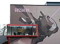
A building in the foundry

S-Bahn stop Salzburg-Kasern
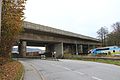
West Autobahn - Kasern valley crossing


The natural area of Kasern

Today the moors that covered the valley floor of the Kasern area have disappeared. During the construction of the western motorway, well-preserved fossil peat layers were found, which suggests the size of the former moorland. The large Kasernmoos with its southern foothills, the Langenmoos , and the Radeckermoos , which once shaped the landscape, are drained and largely built up. The preserved green space in the valley has only been preserved on a small scale as a meadow and partly used as an allotment garden. The small remnants of moorland moor forests and forest knolls in Kasern had to be abandoned as a protected part of the landscape in 2002 as a result of the increasing isolation and devaluation by the surrounding industrial area.
Remarkable today are the preserved pond and its surrounding species-rich litter meadow, near-natural remains on the Plainbach, as well as the avenue of lime trees that is now called Wickenburg-Allee. The pond in Kasern ( GLT 21 ), the avenue of lime trees in Kasern ( GLT 56 ) and a piece of the stream in Kasern ( GLT 55 ) are protected as protected parts of the landscape .
The southern part of the landscape - including the two north arches of the Salzburg-Nord junction with its old forest in the north-eastern loop - belongs to the Plainberg landscape protection area ( LSG 49 ).
Personalities
- Erik Wickenburg (1903–1998) Austrian journalist and writer; born in today's Kasern
Web links
- Kasern in the Salzburgwiki of the Salzburger Nachrichten
proof
- ↑ Post code for Kasern changed. (No longer available online.) In: salzburg24.at. September 22, 2010, archived from the original on August 6, 2017 ; accessed on January 16, 2018 . Info: The archive link was inserted automatically and has not yet been checked. Please check the original and archive link according to the instructions and then remove this notice.
-
^ Franz Hörburger: Salzburg Place Name Book , edited by Ingo Reiffenstein and Leopold Ziller, ed. from the Salzburg Society for Regional Studies, Salzburg 1982 (without ISBN);
Ingo Reiffenstein: The names of the Salzburg districts . In: Salzburger Volkskultur 36th year, November 2012, p. 77, column 2 ( pdf , article online from history , stadt-salzburg.at).
See also place names (etymology) . In: Salzburger Nachrichten : Salzburgwiki . - ↑ Franciscan Cadastre (layer online on SAGIS )
- ↑ a b Oberascher bell foundry . In: Salzburger Nachrichten: Salzburgwiki .
- ↑ Regional Planning Act as of January 1, 1939; see. also council meeting on February 13, 1939 ; Minutes (AStS, BU 1541, Bl. 2–4), In: Minutes of the council meetings of the Gau capital Salzburg 1939–1944 , AStS, BU 1541–1543, edit. v. Magdalena Granigg, p. 8 (pdf, stadt-salzburg.at; 2.7 MB)
- ↑ The numbering in the case of cadastral division is common in Austria, as this makes it easier to update the land register .
- ↑ Start of autobahn construction in Austria (1945–1954): The strange role of the "autobahns" near Salzburg between 1945 and 1954 ( page no longer available , search in web archives ) Info: The link was automatically marked as defective. Please check the link according to the instructions and then remove this notice. . In: Verkehrs-Notizen , wabweb.net, accessed December 14, 2012; In particular, table of the state of construction and expansion of the bridges east of the section completed by 1941
- ↑ It was not until June 19, 1953 that the Salzburg state government issued a traffic ban “for pedestrians, cyclists and non-pneumatic vehicles as well as a ban on driving cattle” on the completed motorway sections. On January 24, 1948, 20,000 spectators came to the “Soap-Box-Derby” on Walserberg. According to The Odd Role… , wabweb.net.
- ↑ A 1 West Autobahn: Start of general renovation of the Kasern valley crossing (Salzburg Nord) - narrowing to two lanes / one-way lane , ASFINAG, press release, Salzburg, March 31, 2011, APA 20110331 OTS0087.
- ^ Tümpel in Kasern in the nature conservation book of the State of Salzburg
- ^ Lindenallee in Kasern in the nature conservation book of the State of Salzburg
- ^ The course of the stream in Kasern in the nature conservation book of the State of Salzburg
_COA.svg)
Location: Salzburg
Cadastral municipalities: Aigen I | Bergheim II | Gaisberg I | Gnigl | Hallwang II | Heuberg I | Itzling | Leopoldskron | Liefering II | Maxglan | Morzg | Salzburg | Siezenheim II | Wals II
Districts ( urban structure) :
Aigen |
Old town
( left ,
right ) |
Elisabeth suburb |
Gneiss |
Gneiss South |
Gnigl |
Itzling |
Itzling North |
Barracks |
Langwied |
Fiefdom |
Leopoldskroner Moos |
Liefering |
Maxglan |
Maxglan West |
Morzg |
Mülln |
Neustadt |
Nonntal |
Parsch |
Riedenburg |
Salzburg-South |
Schallmoos |
Taxham
Landscapes:
Hellbrunn |
Gaisberg |
Heuberg
City districts (settlement identification) :
Abfalter •
Aigen •
Outer Stein •
Elisabethvorstadt •
Gaisberg •
Glanhofen •
Glas •
Gneiss •
Gnigl •
Hellbrunn •
Herrenau •
Kasern •
Kleingmain •
Langwied •
Leopoldskron •
Liefering •
Maxglan •
Mittermoos •
Morzg •
Nonntal •
Obermoos •
Parsch •
Riedenburg •
Rott •
Sam •
Schallmoos •
Taxham •
Untermoos
Rotten:
Heuberg •
Himmelreich •
Loig •
Pointing |
Settlements:
Eichethofsiedlung •
Kendlersiedlung |
Groups of houses:
Salzburg Airport •
Hellbrunn Zoo
Other locations: → See the districts
Counting districts: Liefering-Nord | Liefering-West | Liefering-Ost | Fief-North | Fief-South | Taxham | Maxglan | Aiglhof / Inner Riedenburg | Old town / Mülln | Maxglan / Airport | Maxglan / Outer Riedenburg | Mönchsberg / Inneres Nonntal / Leopoldskron | Outer Nonntal / Freisaal | Leopoldskron / Moos | Thumegg / Gneiss | Kleingmain / Morzg | Herrnau / Alpenstrasse-West | Josefiau / Alpenstraße-Ost | Hellbrunn | Itzling-West / Haguenau | Itzling | Sam / Kasern | Elisabeth suburb | Schallmoos | Gnigl / Langwied | Neustadt | Right old town / Andräviertel | Kapuzinerberg / Steinviertel | Parsch-West / Aigen | Parsch-Ost / Aigen | Gaisberg | Aigen / glass
Cadastral communities (shares) : Bergheim II | Hallwang II
Settlement areas: barracks
Counting district (shares) : Sam / Kasern
| Previous station |
|
Next station |
|---|---|---|
| Hallwang-Elixhausen | Sbg Kasern | Salzburg Central Station |