
Sam (Salzburg)
|
Sam ( district ) settlement area |
|||
|---|---|---|---|
|
|||
| Basic data | |||
| Pole. District , state | Salzburg (city) (S), Salzburg | ||
| Judicial district | Salzburg | ||
| Pole. local community | Salzburg ( KG Hallwang II ) | ||
| Locality | Salzburg | ||
| district | Langwied | ||
| Coordinates | 47 ° 49 '41 " N , 13 ° 3' 55" E | ||
| height | 434 m above sea level A. | ||
| Residents of the stat. An H. | 1300 (approx.) | ||
| Post Code | 5023 Salzburg-Gnigl | ||
| prefix | + 43/0662 (Salzburg) | ||
| Statistical identification | |||
| Counting district / district | Sam / Kasern (50 101 42 [3]) | ||
| Langwied district, Sam settlement area on the left | |||

|
|||
| Source: STAT : index of places ; BEV : GEONAM ; SAGIS ; SAGIS | |||

Sam is a settlement in the Langwied district of the statutory city of Salzburg . The location on the outskirts is characterized by single and terraced houses and extensive green space.
geography
Sam is located in the northeast of the city of Salzburg near the city limits of Hallwang , about 3½ kilometers from the city center. The border to Gnigl is formed by the Alterbach , the border to Itzling by the railway clasp Westbahn - Salzburg-Tiroler-Bahn / marshalling yard . Sam has about 1,300 residents.
Bergsam (421), Langmoos (424), Itzling-Ost (422) and parts of Gnigl-Nord (425) also belong to the counting area Sam of the counting district Sam / Kasern (42 ).
Separated by a narrow strip of meadow, Langwied-Esch adjoins to the southeast , but no road leads directly there.
- Neighboring locations
|
Kasern (Stt.) |
Nussdorf Bergsam |
Söllheim (Gem. Hallwang , district Sbg.-Umgebung ) |
| Itzling East (Stt. Itzling ) |
.svg)
|
Langmoos Esch-Mayrwies (According to Hallwang , district Sbg.-environment )
|
| Gnigl North (Stt. Gnigl ) | Langwied Esch |
history

The old Samer farm
The old farm was mentioned in a document as Savme as early as 1250 and, together with the entire surrounding area, was under the ownership of St. Peter's Abbey. Today's Samer farm (or Samhof) refers to an old farm in the flat embankment directly above the new settlement, which got its name again from the Samers , the profession that in the Middle Ages and also in the early modern times goods from the Brought the Mediterranean to Salzburg. Saum was the weight of the individual load carried, Säumer or Samer were the names of the traders who often supplemented their meager income in agriculture with trading activities.
The Samer settlement
The area originally belonged to the Hallwang municipality , Esch village . The first connection was created with the construction of the Salzkammergut local railway (opened in 1891), which rose here via Söllheim.
The settlement was built during the period of the authoritarian corporate state (see also Austrofascism ) and was inaugurated on November 3, 1935. This new settlement on the outskirts was intended to counteract the general housing shortage and combat high unemployment in the construction industry. In the form of building, however, instead of the dense urban building, at that time often disparagingly referred to as "socialist mass housing", the open "down-to-earth" building on the outskirts - similar to the "intact living and economic community in the farmhouse" should be promoted. With the fear of increasing radicalization of the workforce, the satisfactory moment was not insignificant for the company. The settlement was built in a place where clay had been extracted from brick ponds for decades for the nearby brick kiln ( Ceconi kiln, Hannak kiln, etc.). After dismantling, the landscape was no longer suitable for agriculture. The brick ponds were largely filled in and filled up in the course of the construction work, but sometimes only later. Only the Bittner ponds in Sam are still preserved today. These are named after one of the two contractors at the time.
The residential area was first called Franz-Ullreich-Siedlung , named after the founder and long-time chairman of the Viennese housing, construction and settlement cooperative Heim (founded in 1912), which had a branch in Salzburg. The settlement comprised 44 residential buildings. The acquisition of a residential property was carried out according to the principle that is still common today when buying condominiums . In addition, the owners were obliged to participate in the construction as part of the voluntary labor service or to pay a corresponding payment. After the Second World War , the original name was dropped and the settlement was renamed Sam , as the entire area had been named before. A monument to Franz Ullreich located at the settlement was removed at an unknown time.
In 1939, Sam - with the whole of what is now the Langwied district - was incorporated by Hallwang into the city of Salzburg.
In the same year the construction of the Westautobahn (then Reichsautobahn, today A1) began here, but this came to a standstill in 1941. The highway was not completed until the later 1950s. A motorway service station was built above Sam, near Nussdorf . In 1957, the Salzkammergut local railway was discontinued and dismantled, the Söllheimer hiking trail remained , which, although gravel, is still formally designated as a state road (L 261). A well-developed bike path runs here today.
Differentiation from Itzling and Gnigl
Itzling-Ost , the Gleisdreieck, is sometimes included in Sam, as Samerstraße still runs there. This has historical reasons, small parts to the west of the underpass, through which the Salzkammergut local railway formerly passed, formerly belonged to Hallwang (cadastral community Hallwang II ). Itzling-Ost also belongs to the official statistical counting district Sam / Kasern . In the modern urban structure, however, it is included in Itzling.
Occasionally, in recent times, the Gnigl-Nord district has been added to the Sam settlement, although this is incomprehensible in view of the development of the settlement. This is due to the fact that the Bachstrasse industrial area of Gnigl-Nord near Sam / Kasern is also statistically recorded - but not the residential areas south of it. The Salzburg-Sam train stop at the marshalling yard is also in Gnigl-Nord.
The Alterbach as the south-east border of Langwied, still spanned by only a few bridges and at least tree-lined here along its entire length, is still a defining dividing line in the urban structure.
Transport, infrastructure and sights
Sam was first connected to local public transport on December 14, 1983 with the former Citybus line W. Today, Sam can be reached by trolleybus line 10 (to Sam-Lankesstraße ) and bus line 23 (main station - Sam - Obergnigl).
The Salzburg-Sam stop of the S-Bahn Salzburg (line S3) has been near Sam, but already in the northern part of Gnigl, since 2005 .
Sam is isolated from road traffic by the many tracks, access from the city is possible via the narrow Samstrasse from Vogelweiderstrasse (crossing of the Westbahn underpass ), and Aglassinger Strasse or Bachstrasse from Gnigl. There is no through road out of town and to Langwied-Esch because of the grassland.
The most important campsite in the city of Salzburg is also located in Sam.
Notable buildings:
- Parish center and church St. Severin , the youngest modern church in Salzburg (Peter Schuh, 2006)
- Kindergarten Sam Alterbach , modern timber construction (architects mayer + seil, 1996–2003)

S-Bahn station Salzburg Sam
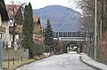
Samstrasse towards Sam, former route of the Salzkammergut local railway


Sam's natural and recreational space
The green space between Sam and Langwied -Esch, the Langmoos , as well as towards Söllheim ( Bergsam ) is today used in a variety of ways as a local recreation area. The Möslweg and the Söllheimer Wanderweg are particularly popular hiking and walking trails. In the center of the preserved green space, east of the settlement, is the Samer Mösl , the last remaining moorland on the right bank of the Salzach in the city of Salzburg (natural monument and protected part of the landscape). The Langmoosweg to the north of the settlement is reminiscent of the former large moor in which the settlement was built.
In the far northwest, towards Kasern, there is still a protected part of the landscape, the Wallpachwald .
literature
- Verein Sam (publisher): Festschrift 50 years Sam near Salzburg , self-published, Salzburg 1985 (brochure without ISBN).
Web links
proof
- 50101 - Salzburg. Community data, Statistics Austria .
- Sam . In: Salzburger Nachrichten : Salzburgwiki .
- ↑ Verein Sam (ed.): Festschrift 50 years Sam near Salzburg , Salzburg 1985, p. 30.
- ↑ Regional Planning Act as of January 1, 1939; see. also council meeting on February 13, 1939 ; Minutes (AStS, BU 1541, Bl. 2–4), In: Minutes of the council meetings of the Gau capital Salzburg 1939–1944 , AStS, BU 1541–1543, edit. v. Magdalena Granigg, p. 8 (pdf, stadt-salzburg.at; 2.74 MB)
- ↑ Verein Sam (ed.): Festschrift 50 Jahre Sam bei Salzburg , self-published, Salzburg 1985, p. 56.
- ↑ Route network and area maps , Salzburger Verkehrsverbund , svv-info.at (various maps, pdf)
- ↑ Sam Alterbach Kindergarten . In: architektur im netz , nextroom.at.
- ↑ Moor forest in Sam in the nature conservation book of the State of Salzburg
- ^ Samer Mösl in the nature conservation book of the State of Salzburg
- ↑ Wallpachwald and Pümpel in Sam in the nature protection book of the State of Salzburg
_COA.svg)
Location: Salzburg
Cadastral municipalities: Aigen I | Bergheim II | Gaisberg I | Gnigl | Hallwang II | Heuberg I | Itzling | Leopoldskron | Liefering II | Maxglan | Morzg | Salzburg | Siezenheim II | Wals II
Districts ( urban structure) :
Aigen |
Old town
( left ,
right ) |
Elisabeth suburb |
Gneiss |
Gneiss South |
Gnigl |
Itzling |
Itzling North |
Barracks |
Langwied |
Fiefdom |
Leopoldskroner Moos |
Liefering |
Maxglan |
Maxglan West |
Morzg |
Mülln |
Neustadt |
Nonntal |
Parsch |
Riedenburg |
Salzburg-South |
Schallmoos |
Taxham
Landscapes:
Hellbrunn |
Gaisberg |
Heuberg
City districts (settlement identification) :
Abfalter •
Aigen •
Outer Stein •
Elisabethvorstadt •
Gaisberg •
Glanhofen •
Glas •
Gneiss •
Gnigl •
Hellbrunn •
Herrenau •
Kasern •
Kleingmain •
Langwied •
Leopoldskron •
Liefering •
Maxglan •
Mittermoos •
Morzg •
Nonntal •
Obermoos •
Parsch •
Riedenburg •
Rott •
Sam •
Schallmoos •
Taxham •
Untermoos
Rotten:
Heuberg •
Himmelreich •
Loig •
Pointing |
Settlements:
Eichethofsiedlung •
Kendlersiedlung |
Groups of houses:
Salzburg Airport •
Hellbrunn Zoo
Other locations: → See the districts
Counting districts: Liefering-Nord | Liefering-West | Liefering-Ost | Fief-North | Fief-South | Taxham | Maxglan | Aiglhof / Inner Riedenburg | Old town / Mülln | Maxglan / Airport | Maxglan / Outer Riedenburg | Mönchsberg / Inneres Nonntal / Leopoldskron | Outer Nonntal / Freisaal | Leopoldskron / Moos | Thumegg / Gneiss | Kleingmain / Morzg | Herrnau / Alpenstrasse-West | Josefiau / Alpenstraße-Ost | Hellbrunn | Itzling-West / Haguenau | Itzling | Sam / Kasern | Elisabeth suburb | Schallmoos | Gnigl / Langwied | Neustadt | Right old town / Andräviertel | Kapuzinerberg / Steinviertel | Parsch-West / Aigen | Parsch-Ost / Aigen | Gaisberg | Aigen / glass
Cadastral municipality (shares) : Hallwang II
Settlement areas: Langwied Esch • Sam | Landscape areas: Bergsam • Langmoos
Other locations: Esch • Geisbichl • Kompenthal • Nussdorf • Substation • Söllheimer Siedlung • Weingarten
Counting districts: (shares) : Gnigl / Langwied | Sam / Kasern

Cadastral communities (shares) : Bergheim II | Hallwang II | Itzling | Salzburg
Settlement areas: Austraßensiedlung • Itzling middle • Itzling east • Wasserfeldsiedlung | Landscape areas: Plainbergfuß
Other locations: Salzburg main station • Itzling West • Itzling church district • Goethe settlement • Grabenbauernsiedlung
Counting districts (shares) : Itzling-West / Hagenau | Itzling | Sam / Kasern

Cadastral communities (shares) : Gnigl
Settlement areas: Gnigl North • Neuhauserfeld • Niedergnigl • Obergnigl
Other locations: Neuhaus Castle • Gnigl marshalling yard
Counting districts: (shares) : Gnigl / Langwied | Sam / Kasern