Itzling middle
|
Itzling center (village ingredient ) Salzburger settlement area |
||
|---|---|---|
|
|
||
| Basic data | ||
| Pole. District , state | Salzburg (city) (S), Salzburg | |
| Judicial district | Salzburg | |
| Pole. local community | Salzburg ( KG Itzling , Salzburg ) | |
| Locality | Salzburg | |
| district | Itzling | |
| Coordinates (K) | 47 ° 49 '20 " N , 13 ° 2' 43" E | |
| height | 423 m above sea level A. | |
| Residents of the stat. An H. | 6546 (2001) | |
| Building status | 526 (2001) | |
| Post Code | 5020 Salzburg | |
| prefix | + 43/0662 (Salzburg) | |
| Statistical identification | ||
| Counting district / district | Itzling (50 101 40 [1–8]) | |
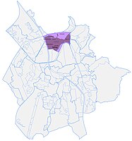
| Plan of Itzling Mitte | ||

|
||
| small portions KG Salzburg enumeration district Itzling with Plainbergfuß, KG Bergheim II : 6948 EW / 633 Born Source: STAT : Gazetteer ; BEV : GEONAM ; SAGIS ;
(K) Coordinate not official
|
||
Itzling Mitte is a settlement area in the Itzling district of the statutory city of Salzburg . The district is mainly a moderately dense residential area with a few apartment block areas.
geography
Itzling Mitte is located in the north of the city, about 3 kilometers from the city center, south of the Plainberg .
The urban area is bounded in the west and south by the Salzburger Lokalbahn / Rosa-Kerschbaumerstraße - August-Gruber-Straße, in the south-east by Bahnhofstraße and Westbahn , in the north by the Alterbach or - including the Plainbergfuß landscape - the city limits.
The urban area also includes:
- Itzling church district as the core zone
- Goethe settlement in the northeast
In a broader sense, the Grabenbauernsiedlung and the Salzburg parts of Gaglham and on Rauchbichl , north of the Alterbach, are also included.
The settlement area comprises over 500 buildings with around 6500 inhabitants, with Plainbergfuß over 600 buildings with around 7000 inhabitants.
- Neighboring locations
|
Hagenau (Stt. Itzling North )
|
Plain (Ortsch., Gem. Bergheim ) |
Kasern (Stt.)
|
|
Wasserfeld settlement * |

|
Itzling East |
| ** | Elisabeth-Vorstadt ** (Stt.) | Schallmoos West (town of Schallmoos ) |
- *Counting area Itzling West
Itzling Mitte with the church district

Today's urban church settlement emerged from an old small farming hamlet only around 1900, especially after the construction of the parish church of St. Antonius , and in the inter-war period developed into a closed settlement area on both sides of Itzlinger Hauptstrasse in the old, independent community of Gnigl- Itzling. In 1935 Itzling was incorporated into the city. The Itzlinger Kirchenviertel is now understood to mean the triangle Itzlinger Hauptstrasse - Camillo-Sitte-Strasse to the parish church - Reimsstrasse.
There were also larger settlement cores south of today's Higher Technical Federal School and in the northeast between the Alterbach in the north and the Westbahn in the east, neither of which have developed any independent place names.
In the course of further development after the Second World War, the meadows and fields between Itzlinger Hauptstraße and the local railway line and the open spaces between Itzlinger Hauptstraße and today's Ischlerbahnstraße were built in step by step.
Overall, the district is now heterogeneous, with mostly loose, not very dense buildings, a number of apartment block areas, south of the church district and commercial on the edges.
The Goethe settlement
The Goethesiedlung, named after the largely undeveloped Goethestrasse, was built in the years after 1970 as the largest residential project in the city at the time. The settlement is one of the densest built-up housing estates in the city of Salzburg: 2500 residents live here on around 13 hectares. There are more than a dozen large, 6-8-storey apartment blocks that are themselves quite loosely, so that the settlement still has plenty of green space.
Companies and educational institutions
Important commercial branches are the Salzburger Milchhof , the ÖBB Postbus headquarters, the Techno-Z with the campus of the University of Salzburg and the vocational training institute , and on the outskirts of the district the freight stations Salzburg freight station of the Westbahn and the local railway. The HTBLuVA Salzburg (structural engineering, design, electrical engineering, mechanical engineering, electronics) is one of the largest schools in Salzburg with 2200 students.
Web links
proof
- 50101 - Salzburg. Community data, Statistics Austria .
- Itzling . In: Salzburger Nachrichten : Salzburgwiki .
- ↑ Statistically, the Plainbergfuß is included in the counting district 40 Itzling.
- ^ ÖBB-Postbus GmbH - Regional Management Salzburg
-
↑ Techno-Z Salzburg ;
Techno-Z . In: Salzburger Nachrichten: Salzburgwiki . - ↑ HTL Salzburg


