Itzling East
|
Itzling Ost (location component ) Salzburg settlement area |
||
|---|---|---|
|
|
||
| Basic data | ||
| Pole. District , state | Salzburg (city) (S), Salzburg | |
| Judicial district | Salzburg | |
| Pole. local community | Salzburg ( KG Itzling , Hallwang II ) | |
| Locality | Salzburg | |
| district | Itzling | |
| Coordinates (K) | 47 ° 49 '36 " N , 13 ° 3' 25" E | |
| height | 427 m above sea level A. | |
| Residents of the stat. An H. | 474 (2001) | |
| Building status | 125 (2001) | |
| Post Code | 5020 Salzburg | |
| prefix | + 43/0662 (Salzburg) | |
| Statistical identification | ||
| Counting district / district | Sam / Kasern (50 101 42 [2]) | |
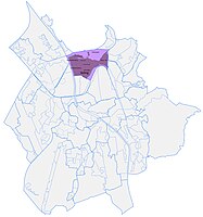
| Plan of Itzling Ost | ||

|
||
| Source: STAT : index of places ; BEV : GEONAM ; SAGIS ;
(K) Coordinate not official
|
||
Itzling Ost , also known as Gleisdreieck , is a settlement area in the Itzling district of the statutory city of Salzburg . The location on the outskirts is characterized by commercial settlements with smaller single house settlements .
geography
Itzling Ost is located in the north of the city, about 3 kilometers from the city center, south of the Salzburg-Nord junction of the West Autobahn (A1).
The district comprises around 125 buildings with around 500 residents.
It is bounded by the Westbahn in the northeast, the Salzburg-Tiroler Bahn in the south, and the Westbahn – Salzburg-Tiroler Bahn / marshalling yard in the east.
Statistically, the Gleisdreieck forms a census district (422) that belongs to the census district Sam / Kasern (42), but according to the city structure of Salzburg it belongs to Itzling.
- Neighboring locations
| Plainbergfuß | Bergsam (Stt. Langwied ) | |
| Itzling middle |

|
Sam (Stt. Langwied ) |
| Schallmoos West (town of Schallmoos ) | Schallmoos East (Town of Schallmoos ) | Gnigl North (Stt. Gnigl ) |
history

The landscape at the foot of the Plainberg was formerly called Rettenlack . with the farm of the same name, once slightly elevated above the wet valley. Here a large developed in the 19th century brickworks , where the by degrading under the peat obtained clay was burned to Maumaterial. The corridors originally belonged partly to the Gnigl community , partly to the Hallwang community , and were incorporated into Salzburg in 1935 and 1939, respectively.

After the construction of the Elisabeth railway line (today's Westbahn) in the 1860s, the settlement area was soon also called eastern Itzling or drenteres Itzling ('drüberes Itzling', located on the other side of the railway). With the construction of the Westbahn – Salzburg-Tiroler-Bahn rail link to the marshalling yard in the interwar period , it was also isolated from the Sam area , and from then on - completely surrounded by tracks - was referred to as the Gleisdreieck .
The Salzkammergut Local Railway (SKGLB) ran through the middle of the area from 1891 and was only dismantled in 1953; the route is now the Landstraße – Samstraße .
Industrial area and brick factory
The area around Ziegeleistraße and Landstraße is mainly characterized in the south by commercial buildings. The Rettenlackstraße is reminiscent of the earlier name. The location was characterized by the transshipment location of the freight railway of the Westbahn / Lokalbahn and Ischlerbahn ( Salzburg freight station , km 61.6) and the remise of the Ischlerbahn ( Salzburg Itzling workshop , km 61.4, today a car workshop), and from the late 1950s the nearby motorway.
A small settlement core , called Ziegeleisiedlung , extends only towards Sam on the Alterbach , which marks the former confluence of the Semererbach (Samerbach) , and was created around the turn of the century before it was overgrown by the industrial area and the railway clasp.
Green forest settlement
In the far north there is north of the highway and Samstraße (at Maxstraße and Negrellistrasse ) a core of small residential buildings, which in the western part in the inter-war period, in the east after the Second World War by clearing of forest near the former inn Green Forest has emerged, and ortüblich Settlement called Green Forest . The name Maxstraße is reminiscent of the former chairman of the Salzburg settlement cooperative , which had the older part of the settlement built.
The remnants of the forest are a protected part of the landscape as a wallpach forest .
traffic

The main traffic axis on the western edge of the city is the Salzburger Bundesstraße (B150), here Vogelweiderstraße , the approach road to the north of Salzburg. However, the district is largely isolated by the rail boundaries. The Fürstenwegbrücke (Baron-Schwarz-Brücke) crosses the Tirolerbahn to Schallmoos for Vogelweiderstraße , and leads to the motorway through the Westbahn viaduct. From the train station comes the one-way road to the viaduct crossing. From there it continues to the district, and continues as Samstrasse through the old Ischlerbahn viaduct to Sam . Shortly before, the Ziegeleistraße leads to Bachstraße to Gnigl-Nord . Apart from these four viaducts and the bridge, there is no access road.
Web links
proof
- 50101 - Salzburg. Community data, Statistics Austria .
- Itzling . In: Salzburger Nachrichten : Salzburgwiki .
- ↑ Wallpachwald and Pümpel in Sam in the nature protection book of the State of Salzburg


