
Plainberg
| Plainberg | ||
|---|---|---|
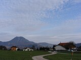
 The Plainberg from the south |
||
| height | 549 m above sea level A. | |
| location | Salzburg , Austria | |
| Mountains | oA | |
| Dominance | 1.67 km → Hochgitzen | |
| Notch height | 109 m ↓ Kasern valley crossing | |
| Coordinates | 47 ° 50 '15 " N , 13 ° 2' 39" E | |
|
||
| Type | Inselberg | |
| rock | Sandstone ( Rhenodanubian Flysch Zone ) | |
| Age of the rock | 70–50 mya ( Maastrichtium - Ypresium ) | |
| particularities | Pilgrimage Church of Maria Plain | |

The Plainberg is a 549 m high mountain located mostly in the municipality of Bergheim north of the Austrian city of Salzburg . It is part of the flysch zone in front of the Alps in the north and was probably settled in prehistoric times. This local mountain of Salzburg gained special importance due to the pilgrimage church Maria Plain located in its area , which is considered the most important place of pilgrimage in the state of Salzburg. The mountain also serves as a recreational area and excursion destination for the population in the vicinity. Almost the entire mountain area is a landscape protection area .
Naming
The name Plain goes back to the Latin of the Middle Ages . The word plaga (slope, field, area) was in the diminutive form plagina (small slope), from which the form plain developed with the omission of the g and a at the end of the word . So the name of the mountain refers to a sloping terrain. The broad south side of the mountain, which is largely treeless in the west, is the motif for the naming. The oldest documented evidence of the name comes from Play from 1285 and in the form Play (e) n from around 1415. The statement that the name of the Plainberg comes from the Plain Castle and the Plainer counts there in Großgmain, southwest of Salzburg (as early as Hübner 1792), is probably not true: Their rule and the subsequent Plain court ended just before the Plainberg, which had belonged to the Radeck court (later Neuhaus ) since the Middle Ages . Nonetheless, both plain names go back to the same Latin root. The name of the community Plainfeld about 10 km east of the Plainberg is not related to plagina .
With the meaning component slope and the increasing ignorance of the actual meaning of plagina or the plain resulting from it , the name was seen more and more as a pure field designation , so that the word part -berg was added more and more to clarify . The composition of Plainberg is first attested from 1803. In addition, in some cases to this day, Plain alone was used as the name for the mountain; for example “Maria Trost on the Plain near Salzburg” (1753), “Archbishop's clergy councils and superiors on the Plain” (1848) and “along the 15 wayside shrines and two pillars to Plain” (1990).

With the sole use of Plain it becomes clear that the field name was also used to designate the Plainberg as a settlement region. Plain has been one of the five localities of the Bergheim political community since the 19th century , which includes the settlement areas on the mountain. The fact that the Plain is understood as the designation of a small region explains the affiliation designations Plainerberg and Plainer Hügel , which were created for the Plainberg . Name variants with hill such as Plainer Hügel and Plainhügel are based on the comparatively low height of the mountain. The meadows on the Plainberg were formerly also known as Plainfields ("The procession went around the Plainfields", 1848). The Plain region is named after other properties such as Maria Plain , Plainbach , Plainbrücke and Plainstrasse . The latter is documented as the Plainer Weg as the northern arterial road from Salzburg at least as early as the 18th century.
The Plainberg is so closely associated with the Maria Plain pilgrimage church there that it is sometimes mistakenly assumed in everyday life that the elevation is named after the place of worship. Some consider the name Maria Plain - conveyed through emigrants - to be the eponymous name for the American village of Plain ( Sauk County , State of Wisconsin), which is also not the case.
geography
topography
Position and extent


The Plainberg lies in the transition area between the Northern Limestone Alps and the Alpine Foreland and forms part of the northern boundary of the Salzburg Basin. It extends in a west-east direction along the northern city limits from Salzburg to Bergheim, almost all of which is in the municipality. Only the first elevations in the south are still in the city of Salzburg. The length of the Plainberg is around 2.4 km, its north-south extent around 1 km including the Rauchbichl , the upstream elevation between the places Gaglham and Radeck in the southeast. If the lowest part of the mountain in the Salzburg city area north of the Alterbach is included, the extent of the Plainberg in north-south direction is a little more than 1.5 km. Towards the north the mountain falls relatively steeply over almost its entire length, towards the south the rise is gentler. The highest point is 549 m above sea level. A. The height of the mountain compared to its surroundings (local point Salzburg 424 m, local point Bergheim 435 m) is relatively low at only around 115–125 meters. The total area of the mountain is a little more than 2 km².
Settlement topography
There are several settlement areas at the foot of the Plainberg and on the mountain itself. They are districts of the political municipality Bergheim and belong to the cadastral municipality Bergheim I:
- Bergheim : Main town of the municipality with a village character on the north-west and west edge of the mountain
- Gaglham : on the south side, roughly in the middle, settlement with a partly rural character
- Hagenau : primarily residential area with the character of a suburban settlement at the south-western foot; a small part of the settlement area west of the Bergheimer Landesstraße L118 belongs to the municipality of the city of Salzburg and is located in the southern half of the small district of Itzling Nord .
- Kemating (also: Plain-Kemating ): settlement area almost centrally located on the mountain with partly scattered settlement character
- Maria Plain : Ensemble of various religious buildings with outbuildings and restaurants on the western of the two hills of the Plainberg (530 m)
- Radeck : primarily residential area on the eastern slope of the mountain
In addition, there is the one-layer Hofstätt on the west side of the mountain . The Rauchbichl in the south-east, which is somewhat separated from the Plainberg, is completely wooded; there are no homes there. The area is intended for hunting as a retreat for roe deer and small game and should not be entered by the general public.
East to northeast of the Plainberg lies the Kasern settlement and industrial area, which mainly belongs to the municipality of Salzburg ( Kasern district ). The smaller part, which also includes the Lengfelden settlement separated from Radeck by a federal road , is located in the municipality of Bergheim. As a district of Bergheim, Radeck has the name Radeck-Kasern together with the Bergheim part of Kasern . Regarding the division of the municipality Bergheim into localities , however, the Bergheim part of Kasern without Lengfelden settlement is in the village of Lengfelden. Like all other Bergheim settlement areas on the Plainberg, Lengfelden-Siedlung belongs to the Plain village , which is also called Maria Plain . The districts of Bergheim and Hagenau at the west foot of the Plainberg belong to the village of Bergheim .
The small Salzburg part of the Plainberg lies in the district of Itzling (cadastral municipality Bergheim II , to which the Salzburg part of Kasern also belongs). The city-Salzburg settlements at the Plainbergfuß are: on the western side of the mountain on the ascent to Kemating, the so-called Grabenbauernsiedlung, a settlement in the middle of the way to Gaglham and one in the east below the Rauchbichl. There is also a campsite there.

Haguenau
Kemating
Gaglham

Radeck


Waters

At the foot of the mountain, parallel to the north edge, flows the approximately 4.3 km long Plainbach. This rises from several sources east of Kasern and runs in a westerly direction before it turns north at Bergheim and flows west of the Bergheim district of Fischach into the stream of the same name , which itself flows into the Salzach after about 1.4 kilometers . A trickle rises north-east of the pilgrimage church Maria Plain and flows north, but dries up in the period of low precipitation.
The lower course of the Alterbach is the southern boundary line of the Plainberg . On the southern slope of the mountain, south of the settlement of Kemating and for the most part in the Salzburg municipality, an approximately 350 m long branch of the Alterbach flows in a south-westerly direction (officially referred to as Alterbach Af ). On the west side of the mountain, a brook crosses the Itzling Nord district of Salzburg in a south-westerly direction from Hagenau , which is officially known as Salzach Sa and flows into the Salzach after 330 meters.
There are small ponds with a few hundred square meters about 330 m south of the Plainkirche, about 300 m northwest of Gaglham and at the northern foot of the mountain in the eastern half. In Radeck, in Maria Plain and about halfway between the pilgrimage church and Bergheim there is a drinking water reservoir.
Land use
In terms of land use, the area is divided up
- 37.6% deciduous forest
- 55.1% grassland (with partial trees)
- 7.3% built-up area
There are forests in the north and east, the southern and southwestern parts of the mountain are free from forests. From a spatial planning point of view, forests are not protective forests or predominantly forestry areas, but primarily have a welfare and recreational function. They should serve to purify the water, to balance the water balance, to balance the climate and as a recreational area for the population.
climate
There is no measuring station on the Plainberg to record the Salzburg climate; however, several measuring points are located within the urban area at different levels above the ground and on other mountains that delimit the Salzburg basin. Exact data can therefore not be given for the Plainberg, but can be understood on the basis of these other measurement results.
The weather conditions around the Plainberg correspond to the climate of the city of Salzburg and that of the Salzburg basin . It is characterized by relatively mild winters and rainy summers. The months with the highest rainfall are June to August, the driest are December to February. The mean amount of precipitation in January was around 60 mm in the years 1961–1990, in July it was a little more than three times that of around 200 mm. The measurements were taken at Salzburg Airport . Precipitation on the Plainberg, a little further to the north, may be slightly lower, as the total amount of precipitation decreases towards the north. There is a closed snow cover in the Bergheim area on average between the New Year and mid-February. Extreme values were recorded in the last century in 1913 with only 14 days and in 1971 with 121 days.
In the Salzburg area there are the inversion weather conditions typical of a geographical basin , in which lower temperatures are present all year round in lower layers than in higher areas. This effect occurs most clearly in the Salzburg Basin at an altitude of 200 to 400 m above ground, but can also be demonstrated at an altitude of the Plainberg in almost 30% of all measured cases and especially in January in around 42% of all measured cases. The extent of these temperature differences in this altitude range is less than 1 ° C in the majority of cases. The phenomenon is most common and most pronounced in the months of October to February. These temperature differences were determined, among other things, on the basis of data collected on the Salzburg Rainberg at an altitude of 518 m. ü. NN , ie about the level of the Plainberg, were collected in the years 1987–1998. In this period, the following monthly mean values were obtained:
| Jan | Feb | Mar | Apr | May | Jun | Jul | Aug | Sep | Oct | Nov | Dec |
|---|---|---|---|---|---|---|---|---|---|---|---|
| 0.2 | 1.9 | 4.8 | 8.6 | 13.4 | 15.6 | 18.2 | 18.0 | 14.2 | 9.8 | 3.8 | 0.8 |

These can be assumed to be very similar for the Plainberg due to the almost identical altitude. Deviations down to about 0.5 ° C are to be assumed due to the greater proximity of the Rainberg to the built-up area. Because the location in inhabited areas - as comparative measurements with other stations in the Salzburg area showed - slightly higher measured values of about this extent. The southern slope of the Plainberg, together with that of the Hochgitzens, is one of the warmest places in the Bergheim community.
As the wind direction in the city of Salzburg, currents in the north-west-south-east direction are predominant in the bottom area. This direction of flow must also be assumed on the Plainberg, as the west-east flow typical of the Alpine foothills only occurs at greater heights at the geographical latitude of the Plainberg and only a few kilometers north of the Plainberg on the ground. Despite its low height, the Plainberg forms a barrier. In the areas in its slipstream, namely in the north-east of the Salzburg district of Schallmoos and in the Sam area , there is significantly less air exchange than in most other parts of Salzburg.
The relative humidity in the Salzburg area is subject to strong diurnal and lesser seasonal fluctuations near the ground, with the differences within the built-up area being between 55 and 90% greater than in the surrounding area. The distribution in higher altitudes is much more balanced ( Gaisberg , 1278 m, mostly between 75 and 80%). On the Rainberg the monthly mean values fluctuate between 69% in May and 83% in November. The measured values for the 670 m high Kapuzinerberg in the center of Salzburg are 1–3% above the values for the Rainberg. For the Plainberg located on the outskirts of the city, values can therefore also be assumed that are within this framework.
geology
The Plainberg lies in the rhenodanubian flysch zone and has the rounded ridges and knolls typical of such elevations. The rock mass consists of flysch , gray-greenish calcareous quartz - to clay - marl - sandstones (short-grain sandstone) , here called anthering formation . For example, on the hill of Radeck there are “marl limestone and sandstones, the latter with shell-like impressions, which are filled with a slate-like mass.” These rocks were formed in the transition period between the Cretaceous and the Old Tertiary around 70-50 million years ago (mya ) ( Maastrichtian to Ypresian , i.e. in the Paleocene at the turn of the uppermost Upper Cretaceous or the lower Eocene ). To the north of the Plainberg- Nussdorfer Hügel train there is a characteristic fault line that grazes from the Muntiglberg (also a Flyschrest) over Heuberg / Petersberg towards Unterkoppl . Here near Kasern there is a geological window of ultra-Helvetian marl , that is, the basement part of the marl. The fault line belongs to the Innsbruck-Salzburg-Amstetten Fault System (ISAM), in which the basement between the Limestone Alps and Flysch is raised in a leaf-like or vertical position and which is offset about 10 km north-south in Salzburg.
During the last Ice Age ( Würm Ice Age , approx. 100,000 to 25,000 years ago) the mountain was hidden under the ice mass of the Salzach Glacier. On the Hochgitzen - Haunsberg massif, the glacier tongues divided northwards and northeastwards (Wallerseelobus), towards the end of the Ice Age the massif was likely to have jutted out of the ice mass as a shiny flysch nunatak . The north-west adjoining plateau of the Salzburg Lake District is completely covered as a terminal moraine by glacial gravel. Then an extensive glacier lake formed in the Salzburg basin , to which the streams from the moraine flowed southwest. With the deepening of the Salzach, the Fischach (from Wallersee ) also exposed the Plainberg – Nussdorf train, which stopped as a cliff in front of the Hochgitzen. The southern foot of the Plainberg is still formed by low glacial terraces, which indicate the further deepening through Schernbach and Alterbach . To the north lies post-glacial moorland (remains are protected in the pond in Kasern ).
The stones extracted in the west near Bergheim in the 19th century were used for building purposes; the loamy weathered cover was exploited economically with the mining of loam on the opposite side of the mountain for brick extraction. The vegetation cover is formed by the mixed deciduous forests and grass areas typical of Flysch mountains.
nature
vegetation

Originally, after the last Ice Age, there was largely a continuous, light forest from the Plainberg to the floodplain area on the Salzach in the northwest, which in the north of the mountain was mainly formed by common ash , sycamore maple and red beech . In the early and high Middle Ages, a large part of this forest was cleared and converted into cultivated land. Remnants of this shadow forest can still be found near the Bergheim cemetery and in the northern lower slopes. Beech trees dominate the upper slopes. The north slope is a fine example of a canyon forest . Between Kemating and Maria Plain, there is a wide range of woody plants with more than 20 different species, including field maple as warmth-loving species and blackthorn below the Calvary . At the northern foot of the mountain at the Bergheim trade center and above Gaglham, residual black alder stocks indicate earlier moor complexes in this area.
Also above Gaglham, the typical beech forest species grows the cyclamen , which is otherwise not found on the mountain ; Over 40 different herbaceous plants thrive in the dry, poor meadows near Kalvarienberg, including the rare white violet (albino forms of various types of violets). Small remnants of wet meadows in the east next to the main road there refer to the former moss from Radeck, which still supplied peat around 1900 and was later converted into meadows. Various cotton grass and sedge species can be found there , among other things .
fauna
In the Bergheim area, intensive agriculture is often practiced ; there are hardly any extensively farmed meadow areas. That is why the zoological diversity has shrunk very much overall, as this soil culture does not offer a suitable habitat for many animal species. Species diversity is expected to decrease further under these conditions. In the Plainberg area there is a remnant of wet meadows near Radeck in the east, which offers favorable conditions as a habitat for a number of butterfly species, but mainly for those that do not have any particular ecological requirements. Of the 72 species historically recorded in Bergheim, only 30 have been sighted since the 1990s. Rarely seen birds in this region that have been sighted in Bergheim are, for example, the gray heron , the white-starred bluethroat and the yellow wagtail , which, however, do not have their nesting sites on the Plainberg, but only pass through here, but used to be largely at home in the Siggerwiesen area.
natural reserve

In 1976, most of it was the mountain area on Bergheimer municipality with the Plainberg landscape protection regulations by the State of Salzburg to the conservation area declared in 1981 and the Salzburg proportion was added ( LSG 49 ). Of this, 201.3 hectares are in Bergheimer and 12.2 hectares in Salzburg. A building ban in the sense of spatial planning has existed at least since 1939. The most westerly meadow areas towards Hagenau are excluded from this. The purpose is “to preserve the natural beauty of the landscape, including the baroque ensemble of Maria Plain, and to preserve the adventure and recreational value of this area”.

In 1978 the group of trees in Maria Plain and in 1987 the linden tree near the Plainkirche were declared a natural monument. The group of trees in Maria Plain consists of two linden trees and five oaks as well as a wayside shrine and a small pond. The historical significance of the point is given as a reason for protection. There two old paths cross, whereby the path leading north from Salzburg is one of the few historical paths out of the city that are still recognizable today. The square is also the end point of the pilgrimage route laid out in 1705 from Salzburg to the Plainberg. The site's worth of protection is also justified aesthetically.
The linden tree at the Plainkirche is a winter linden tree that was planted in 1910 to replace a linden tree that used to stand there. The tree stands around 50 m southwest of the basilica, is around 15 m high and has a crown diameter of 13 to 15 meters. The nature of the landscape, the recreational value (the place is a popular rest stop) and the cultural and historical value are cited as reasons for the need for protection.
In addition, there is an area of 0.2 hectares with the oaks on Gaglhamerweg in Salzburg , which was declared a protected part of the landscape of the city of Salzburg in 1987 . Since 1992 the only 420 m² large oak stock near Hagenau north of this settlement has been designated as a protected part of the landscape.
history
Prehistory and Antiquity
The area around Bergheim should have been inhabited by people as early as the Neolithic Age (around 10,000 BC). Finds have also been brought to light on the Plainberg and in the immediate vicinity that prove human settlement in this area in prehistoric times. A drifting hammer made of dark serpentine from the Neolithic Age was found in Kemating in 1893 (dated around 4000 BC). It is believed that it was already used for metalworking. Also in Kemating in 1977, several collar-shaped copper bars from the early Bronze Age (2000–1800 BC) were discovered in the earth material supplied from Lengfelden . On the east side of the Plainberg in the Kasern area there is a settlement from around 2200–1600 BC. And in 1850 a bronze ax with a medium-sized shaft was found near Radeck . Immediately northeast of the Plainberg, not far from the Plainbach, a bronze dagger was found with three rivet holes for attaching a wooden handle and dating from the Middle Bronze Age (approx. 1500 BC). On the west side of the Plainberg, several Bronze Age objects were found in the quarry that existed near Bergheim in the middle of the 19th century, but most of them were lost. Six bronze robe needles with disc or spherical heads that date back to the 14th to 13th centuries BC have been preserved. To be dated. Furthermore, several ceramic fragments and bronze bracelets were discovered in 1855. The clasps probably come from the Younger Urnfield Period (10th – 9th centuries BC). There are fewer finds in the Bergheim area from the subsequent Iron Age . A small bronze ear spoon found during the regulation of the Plainbach near Kasern in 1948 comes from the Older Iron Age ( Hallstatt Period, 800–450 BC) . On the southern slope of the Plainberg near Gaglham, at the level of today's motorway route, a settlement from this period has also been proven. During the construction work on the autobahn in 1939, traces of two wooden structures measuring around 5 × 10 meters were found there, facing south.

An excavated manor on the Plainberg in Kemating reminds of the later time when the area belonged to the Roman province of Noricum . A L. Vedius Optatus in the second half of the 3rd century is proven to be one of the owners of the approximately 32 × 10 m building. The structure possibly existed until the 4th century and was in the form of a villa rustica (country villa). However, it was larger than one and, in addition to the living rooms with underfloor and wall heating, had a bathroom with cold, tepid and hot water basins and a room with a sweat basin. There was also an open columned hall with a view towards the south towards the city of Iuvavum , today's Salzburg. Local flysch sandstone was primarily used as building material and, in smaller quantities, tufa (possibly from a deposit near Plainfeld) as well as Adneter and Untersberg marble .
The structure was found in 1907 on two agricultural plots about 40 cm below the surface and excavated for documentation purposes. The site is no longer exposed. The objects found (coins as well as utensils and tools mainly made of iron) are - just like the prehistoric finds - in the Salzburg Museum in Salzburg.
In the Bergheim area, there are archaeological references to several graves, mainly from the period of late antiquity and the early Middle Ages, none of which are located on the Plainberg itself. A former cemetery closest to the mountain is located in the center of Bergheim.
Middle Ages and Modern Times
From the time after the collapse of the Roman Empire and from the early Middle Ages, there is no archaeological evidence of settlement on the Plainberg. Nevertheless, the entire region around Bergheim was thinner, but still inhabited. The place name Gaglham , which probably goes back to the Old High German personal name Gagilo of a farmer, is considered to be evidence of settlement of the Plainberg in the early Middle Ages . -ham is a form of the basic word -heim . The oldest documentary evidence as Gakilheim comes from the year 991. In the same year the place Kemating is documented for the first time. The place name is formed from the Old High German word cheminata ( kemenate ), which was taken over as a foreign word from the Middle Latin caminata , meaning a room with a fireplace (= heatable) room . The place name Kemating actually means for those who live in a heatable house and thus also indicates the settlement of the Plainberg. Both Gaglham and Kemating were initially individual farms, which - as can be deduced from the land analysis - were divided up due to inheritance relationships. The place name Radeck refers to the land reclamation there. The name is possibly related to the word clearing and thus proves the type of land reclamation, which was widely practiced in the Middle Ages by clearing forests. The place name appears for the first time around 1225 as Radekke in connection with the construction of the castle there. The clearing is likely to have taken place at least in the 11th century in the course of earlier land reclamation measures by the Salzburg archbishops. However, a woman named Alheidis de Radecce is said to have been mentioned as early as 888 .

As early as the Middle Ages, the Plainberg was the border area between Salzburg and Bergheim, and until the 14th century the area was administered first by the lords of Bergheim and later by those of Radeck, who were ministerials in the service of the Salzburg archbishops. After the demise of the Radeck lords around 1330, the castle there, built around a century earlier, became the seat of a nursing court of the archbishop's administration. The area of responsibility included the present-day communities of Plainfeld , Koppl , Eugendorf , Hallwang , Elixhausen and Bergheim; the Plainberg was in the southwestern part of the judicial district. In 1508 the seat of jurisdiction was abolished at Radeck Castle. The entire Bergheim area and thus also the Plainberg came to the newly established Neuhaus maintenance and land registry office with its seat at Neuhaus Castle in Gnigl , which is now a part of Salzburg.
In 1568 a map was published, a woodcut map by Philipp Apian called Bavarian land tables . The place Bergheim was probably recorded on this for the first time, Radeck is the only place on the Plainberg to be seen as a castle. Not until 1716 was the Plainberg listed on the map of Odilo von Guetrather Plain as another village. This map, published by the map publisher Johann Baptist Homann in Nuremberg , also shows the route to the pilgrimage basilica for the first time.
- The importance of the pilgrimage site Maria Plain
Although the Plainberg has always mainly been important as an agricultural area for the farmers in order to meet their payment of taxes in kind and money to the authorities, the name of the mountain rose by leaps and bounds in the middle of the 17th century with the installation of a legendary miraculous image of Maria Plain . This area on the Plainberg had a religious connotation for a long time, because a farm in Kemating had been given to a hospital for the poor as early as the middle of the 12th century , and such facilities were run exclusively by the church at that time. The place where the icon was erected on the Plainberg was more or less a religious attraction from the very first moment.

The popularity of the Plainberg has been largely determined by it since the establishment of the Maria Plain pilgrimage site in 1674. Shortly after completion of the pilgrimage church, "Plainberg" was equated with the house of God, for example in a biography of the Archbishop of Salzburg Johann Ernst von Thun and Hohenstein published in 1709 : "He sacrificed MARIÆ to the mother of GOD on the Plain mountain in Salzburg, MARIÆ consolation. ”This fact continued in the following, evident for example in the description of the northern surroundings of Salzburg by Lorenz Huebner from the year 1792. Also in 1848“ Plain ”stands as a name for the mountain, representing the place of pilgrimage and in 1937 even the name "Maria Plainberg". The Plainberg and Maria Plain are intellectually inseparable to this day.
With the installation of the Maria Plainer image of grace, an unexpected rush of pilgrimages began. From 1657 to 1674 alone, the year of consecration of the newly built basilica, around 34,000 masses are said to have been read. This was associated with an economic upswing in the whole area, because with the new arrival of pilgrims, there was an increased need for hospitality and accommodation, as well as the possibility of selling food and other goods. As a result, several shops and inns were built to meet these needs. In today's Salzburg district of Itzling, several inns and hostels were built, and the landlord in northern Lengfelden also recorded sales growth.
At that time there was no general mobility as it does today; the majority of the population was tightly bound and sedentary. Only members of the upper class, merchants, journeymen and - on the lowest social level - the "traveling people", which meant tramps, vagabonds and beggars, were on the journey. Therefore, in Maria Plain one saw not only pious pilgrims, but with the latter group of people also unpopular people, which led to various protests by the local population.

Because in the centuries of modern times it was common for beggars and vagabonds to ask for alms in the vicinity of churches, especially at pilgrimage sites. This custom came from the idea of Christian Caritas , love of one's neighbor. Here people were able to practice mercy in everyday life through donations that originally consisted primarily of bread. Donations of money did not arise until the end of the 18th century. In return, the beggars thanked the benefactors with prayers, which over time became a ritual "God bless".
Several years after the construction of the Maria Plain pilgrimage church, but no later than 1687, the establishment of the "Plainbegel" was created. The Benedictines of Maria Plain, who were responsible for pastoral care there, as well as the responsible secular nursing court in Neuhaus, granted twelve poor people the privilege to beg the pilgrims in front of the church. These chosen ones belonged to that social subgroup of beggars who were considered innocent with regard to their disadvantaged living situation and who were distinguished from the unpleasant, “lazy” beggars. With the permission to beg was also the possibility of free accommodation. The donations to the beggars were in the form of bread that could be bought in the adjacent shops. The donated baked goods were collected for the plain beggars during the day and only distributed in the evening. Excess pastries could be sold back to the bakers at a reduced value, so that on the one hand the beggars could earn money and on the other hand this meant a lucrative business for the traders. In return, the privileged plain beggars were given the task of forbidding others, especially the beggars and vagabonds who often came from far away, to beg. They were supported and encouraged to do so by a bailiff appointed by the nursing court. From 1793 this begging privilege may have only been owned by ten people.
With the realization, which was increasingly perceived in the 18th century, that poverty is not God-given, but that action can be taken against poverty in society in a targeted manner, also changed e.g. T. the attitude towards beggars. On the one hand, the view was expressed on the one hand that the poor are responsible for their own condition, on the other hand, that the state should take over the task of poor relief and poverty reduction. Against this background, the Plainbettel was abolished in 1804, which was welcomed by the official authorities, but which the local merchants were, of course, disapproved of.
19th century and First Republic


During the French wars after 1800, as part of the first campaign by France against Austria, the Bergheim area was the scene of clashes between the two countries, but no acts of war took place on the Plainberg itself. Attacks by the advancing French soldiers on the local population are also unlikely to have taken place on the mountain.
In addition to the local farmers and clergymen who had moved to the Plainberg, other new residents also came into the area from at least the 19th century. Even in the historical descriptions of the Plainberg and Maria Plains, the scenic beauty of the area is repeatedly emphasized; the south side of the mountain facing the city of Salzburg offers comparatively wide views and, with this location, served as a residence for professors emeritus from Salzburg University at the turn of the 19th century .
With the exception of a piece in the west, the Plain comprised most of the Plainberg and the next area to the east of it. The Berg settlement, which today belongs to the Hallwang community, also existed there as a settlement area. In the 19th century and later, the following population figures were collected for Plain:
| year | Houses | Residents |
|---|---|---|
| 1812 | 22nd | 132 |
| 1839 | 21st | 113 |
| 1869 | 22nd | 133 |
| 1890 | 23 | 153 |
| 1900 | 25th | 174 |
| 1910 | 30th | 263 |
| 1991 | 74 | 385 |
| 2006 | k. A. | 219 |
The ratio of men to women was always balanced. Almost without exception, the denomination indicated was Roman Catholic. The following details are available for the Plainberg for the years 1812 and 1890:
| Settlement | 1812 | 1890 | |
|---|---|---|---|
| Residents | Houses | Residents | |
| Gaglham | 13 | 2 | k. A. |
| Gaglham including single-layer houses Hofstätt and Plainbrücke | k. A. | 4th | 46 |
| Kemating | 30th | 6th | 29 |
| Plain | 42 | k. A. | k. A. |
| Maria Plain including the Berg - Maria Plain railway stop | k. A. | 7th | 34 |
| Radeck | 38 | 6th | 44 |

In the years 1828 and 1829, in the course of the creation of the Franziszeische cadastre , the new tax communities were also set up in the Bergheim area. With the cadastre , all properties in the entire Austro-Hungarian monarchy were re-measured and recorded in plans due to a state reorganization of the basic taxation. The Plainberg was mainly assigned to the new cadastral community Bergheim, which today bears the name "Bergheim I". The current cadastral community Bergheim II with the southernmost part of the mountain was originally part of the cadastral community Vockenberg, which at that time also comprised today's cadastral community Voggenberg.
In the 19th century, on the recommendation of the authorities, fruit trees were planted more and more frequently along roads and around farms in rural areas, which also happened on the Plainberg. On the occasion of the 40th anniversary of the reign of Emperor Franz Joseph in 1888, Joseph Nussdorfer, who lives in Maria Plain, planted the "Kaiser-Jubiläums-Obstbaumallee" along the road to the pilgrimage site.
In the second half of the 19th century, Bergheim was restrictive of the new social and political movements. Both social-democratic and Greater German efforts were in the minority, one was firmly attached to the views as they were represented in political Catholicism into the 20th century . In their wake, a so-called fraternity association was established in Bergheim in the first decade of the 20th century - just like in other rural communities in Salzburg. Single farm boys and male servants gathered in this association, which is closely related to the farmers' union. A boys' day with around 300 members was held annually in Maria Plain , which is to be seen as a stately representative in terms of the number of inhabitants.
On April 25, 1901, the first post office in the Bergheim area was built in Kasern, because it was close to the railway. From now on, this was also responsible for delivering the post to the Plainberg, which a post office in Salzburg had previously taken over for this rayon. The post was delivered several times a day on weekdays, on Sundays the delivery was locally restricted. On the Plainberg only Maria Plain received broadcasts on Sundays. From August 1, 1912, there was a post office in the village of Bergheim (limited in its tasks compared to regular post offices) at the Salzburg post office 1; the mail delivery mode remained unchanged until after 1945, when Bergheim became an independent post office. The Kasern post office was closed in 2009, and mail has been delivered to the Plainberg from Salzburg-Itzling again since 2005.
In the run-up to the creation of the Salzburg Festival , a suitable location for an opera house in Salzburg had been sought since the end of the 19th century. Even before the First World War , while taking a walk on the Plainberg, Friedrich Gehmacher and Heinrich Damisch, two Salzburg citizens, had the idea of building a concert and opera house at this point, among other things because of the beautiful view from Maria Plain to Salzburg. With the outbreak of war, the plan was not pursued any further.
After the World War, soldiers returning home marched through Bergheim and there was fear of looting and violence. In fact, some sexual assaults on women took place in 1920, including in the Plainberg forest. During the economic crisis, local emergency money was issued in Bergheim between September 1920 and 1922 as an urgent measure against inflation . The south side of the Plainberg with the pilgrimage church Maria Plain was shown on a 10 Heller note.
Time of National Socialism until today

After Austria was annexed to Nazi Germany in March 1938, the Plainberg was annexed to the city of Salzburg, but came back to the municipality of Bergheim after 1959. In 1939/40 a labor camp of the National Socialist Reich Labor Service was set up between Bergheim and Hagenau . The inmates were used, among other things, for work to regulate the Plainbach and for the construction of the Reichsautobahn , which was to continue from Munich to Vienna. The route corresponds to today's western motorway (A 1) and runs over the southern slope of the Plainberg. After the end of the war, the American occupying forces set up a refugee camp on the site that had already been leased from the Bergheim parish by the Nazis. At first it was intended as a reception camp for former members of the Wehrmacht. In October 1946 , 391 people were housed in the settlement comprising 16 wooden barracks , which was originally intended for 250 people, 95% of whom were Danube Swabians . In autumn 1948 there were over 460 residents. The camp developed its own social structure with a kindergarten, school, food supply, sports clubs and an originally officially appointed camp police. In 1950, a typhoid epidemic broke out due to poor sanitary conditions , after which the camp was temporarily closed. In 1952 the Bergheim camp became self-governing and was dissolved in the following years with the sale of the site to settlement cooperatives at the end of 1956. Today the Kirchfeldsiedlung is located there , in which some former refugees and their descendants also live.

At the beginning of 1939, most of the Plainberg from Bergheim came to the municipal area of the city of Salzburg from other incorporations. During the Second World War - parallel to other church confiscations - in 1941 the clergy from Maria Plain had to leave their place of residence in the superior building, as the premises were used to house children as part of the Kinderland deportation (evacuation of children from cities threatened by air raids). The home, run like a camp, was officially referred to as the Maria Plain Youth Hostel . The fathers were temporarily accommodated in an outbuilding, the Bindergut. In 1943, a small air raid shelter for around 30 people was built at the eastern end of the mountain by the municipality of Salzburg, triggered by the “Führer order to build public air raid shelters throughout Germany”. This makes it by far the smallest of all such shelters built in the city of Salzburg at the time. Forced laborers and prisoners of war were used for the work.
After the war, the Bergheim community made efforts to get the mountain back, which only succeeded by complying with Salzburg's request to incorporate the slaughterhouse north of Bergheim and negotiating an exchange of territory. The 216-hectare Plainberg area was exchanged for a 35-hectare strip of land, partly only around 65 m wide, along the Salzach towards the north up to and including the slaughterhouse, today's Itzling-Nord . This agreement came into effect on July 13, 1950. A part of Kasern, however, remained with Salzburg - allegedly in order not to destroy the village character of Bergheim, since the new Salzburg district had developed into a commercial and industrial area. However, industrialization of the area had already started around 1900.

In 1963, regular garbage disposal was introduced in parts of the municipality in Bergheim. The Plainberg area was one of them from the start.
Today the Plainberg on its west side with the sacred buildings is a popular place for walkers and tourists. The rest of the mountain is little used for recreational purposes. The isolated footpaths that are located on the hill due to the tree population hardly offer any views are not signposted. The last forest road from Maria Plain towards Radeck in the upper mountain area is not yet shown in the maps.
economy
Agriculture, livestock, hunting

Mountains in the flysch zone mostly have forest, but also meadow areas. The tree-free areas were probably used for agriculture in the earliest times. The excavation of the manor from Roman times in Kemating suggests that agriculture was practiced in the area in ancient times.
It is reported from the early 19th century that the south side of the Plainberg was used for agricultural purposes centuries ago. The fields were fertile and the local farmers showed their wealth on the outside. Grain cultivation dominated. In 1833, the arable land of the cadastral community of Bergheim, which was largely taken up by the Plainberg, consisted of one third for growing winter grain, another third for oats and the rest was divided into clover, fallow land and some flax. In terms of livestock, cattle were kept almost exclusively. For 1817 a livestock of 15 oxen, 47 cows and 1 horse is recorded for the village of Plain. There were very few sheep in other Bergheim villages. During the entire 19th century - as in the entire province of Salzburg - the number of cattle should not have changed significantly. Today there are still five active farmers on the Plainberg, including Radeck.
On the meadow in front of the Maria Plain pilgrimage church, the “Lorenzimarkt” or “Plainmarkt” was held annually from 1830 to 1961 (with the exception of the war years 1940 to 1944) on St. Lawrence's Day, August 10th. It was a folk festival of cattle market and Kirtag , at which the cattle prices important for agriculture were set for the following season. Horses and cattle were traded, but clothes, household goods and similar goods common for a fair were also on sale. The cattle trade took place mainly in the morning, the afternoon was more sociable. The Plainmarkt was a popular place; Examples of consumption are: “8,000 frankfurters, 4,000 crackers, 150 bars of cold cuts, 10,000 more sausages and 1,200 sausages as well as 20,000 bread rolls. In the butcher's shop [of the adjacent Maria Plain inn], three bulls, two 600-pound heifers, four pigs and four calves were slaughtered. ”The reason for the abandonment of the Plainmarkt in 1961 is the increasingly difficult conditions for driving cattle (motorized road traffic) as well as called the competition of the cattle market in Maishofen im Pinzgau .
The forests between Maria Plain and Radeck were not developed at least until the High Middle Ages; later they were used for hunting. In the 19th century, just like in many other rural communities in the region, community hunts in Bergheim were given to aristocrats and upper-class citizens for financial reasons. There was a great deal of hunting activity in the Bergheim forests, and the game was kept in view of this fact. Therefore, damage from game and hunting activities was often recorded in the adjacent arable land, so that towards the end of the century legal regulations were created to reserve the right to hunt for landowners. The abundant game population has now decreased considerably. The Bergheim community hunt has its core zones on the Hochgitzen and, to a lesser extent, on the Plainberg, which is only rarely hunted today. While in the past, atypical species of game such as wild boar and fallow deer could also be hunted in Bergheim, there is currently only a total of around 150 to 200 roe deer and a very reduced population of small game.
Industry, trade and commerce


The Bergheim commercial center with numerous companies is located just north of the Plainberg. In addition, the construction of a plant for the production of renewable energy ("Ökoenergiepark Bergheim") is planned at the northern foot of the mountain.
Immediately beyond the current Salzburger Straße (B 150), which as an arterial road from Salzburg passes the south-eastern flank of the mountain to the autobahn, there was one of three brickworks located in and around Salzburg (today's Rettenlackstraße ) south of Kasern with the “Redlacken” . In this clay pit, later also known as “Röttelacken”, red clay was extracted for painting the porcelain produced between 1734 and 1848 in the Salzburg district of Riedenburg . A brick factory still existed there in the first half of the 20th century. A chemical factory, a bell foundry and a soap factory were also located there at this time. In addition, peat was extracted here before. Today there are a number of commercial companies in the area, the former peat extraction is no longer recognizable.
On the west side of the Plainberg there was a quarry near Bergheim until 1897, the stones extracted there were used as building material for church buildings in the area, including the pilgrimage basilica Maria Plain and the Benedictine abbey Michaelbeuern . At least until the end of the 19th century there were several quarries east of the Plainberg, of which the one immediately southeast of Radeck was operated from the 1880s.
At the turn of the 20th century, the economic range in the area of the Plainberg itself was much wider than it is today. In addition to agriculture, the following companies were named for Maria Plain in 1901: 1 bread trade, 1 meat trade, 2 shops (meaning general stores), 1 hay trade, 1 mill builder, 1 shoemaker and 1 innkeeper. In addition to the pilgrimage church, souvenirs and devotional objects are also traded today.
The hospitality industry became particularly important in the Plainberg area with the advent of pilgrimages. The Maria Plain inn next to the pilgrimage basilica ("Plainwirt") has existed since 1654 and has been run by the same family since it began. The building had previously served as accommodation for priests and was converted into an inn after their move into the superior building of Maria Plain. In 1687 the building was rebuilt. At the turn of the 20th century there were two other restaurants in Radeck: the Schwarz'sche Gasthaus and the Jägerwirt, which is still there. The Jägerwirt also had a salettl set up next to it , which has been an exhibition object in the Salzburg open-air museum in Großgmain since 1994 . Furthermore, a further catering establishment was opened on the mountain in 1914 on the route coming from Salzburg at the intersection with the road to Radeck, the "Plainlinde", which also still exists.

Gasthof Maria Plain
(Maria Plain)
Gasthaus Plainlinde
(Maria Plain)
Gasthof Jägerwirt
(Radeck-Kasern)


Today the gastronomic events on the Plainberg are still determined by the pilgrimage site and the related tourism, but also by non-religiously motivated excursion traffic. In addition, the general number of tourists in Bergheim - measured by the number of overnight stays - more than tripled between 1986 and 2008.
Today there is a cider tavern in the south-east of the mountain in the Salzburg area, as well as the Panorama Camping Stadtblick campsite , also with an attached restaurant.
Radio factory
The " Radiofabrik " is a private radio broadcaster in the city of Salzburg; it is one of Austria's free radios . From 2001 onwards there had been a transmitting antenna for them on the roof of the Gasthof Maria Plain next to the basilica, but for broadcasting reasons it was relocated to the Hochgitzen, a mountain a little further north and also in the municipality of Bergheim. The new transmission station set up at the beginning of 2013 was named after the British mathematician and programmer Ada Lovelace (1815–1852) and was named "Ada".
traffic


The Plainberg was - so it can be concluded on the basis of finds - accessible from the earliest times. The main route up the mountain (now called "Plainbergweg") has been the road from Itzling to Kemating for centuries and then on the one hand east to Radeck (today 'Plainwaldweg') and on the other north the Plainbergweg on to Maria Plain. As early as June 27, 1909, a driving ban for motor vehicles was issued for this road from the Plainbrücke at the foot of the mountain to the basilica. The way to Radeck ended at the place in the street leading from the Salzburg district Gnigl to Lengfelden and beyond into the Upper Austrian Innviertel . Today it is the four-lane Lamprechtshausener Straße (B 156). There is also an access road on the mountain from Itzling to Gaglham (called "Gaglhamerweg" since 1944) with a connection to the road to Radeck and roadways from Bergheim to Maria Plain and Kemating. Furthermore, there are some footpaths, one of which - because it offers little view and is only rarely used - leads over the highest point of the mountain. The exit to the north can only be taken from the mountain on foot and mostly via stairs, the "Plainstiege". About the Plainberg and Maria Plain lead past a distance trails of Rupertiweg and Arnoweg and the Salzburg section of the Austrian St. James .
In the southern edge of the Plainberg, partly at the level of the municipal boundaries of Salzburg and Bergheim, the Westautobahn (A1) crosses the area; on the eastern side is the Salzburg Nord exit, where there is a connection to the B 156 towards Salzburg city center and north.

On February 1, 1885, at the settlement of Berg (today part of the Hallwang municipality), about 800 m east of Radeck, the “Berg - Maria Plain” railway stop for the Empress Elisabeth Railway , which opened in 1860, was created - today's Westbahn stop at Salzburg-Kasern . In 1886 the Salzburg Local Railway was opened, which passes the foothills of the Plainberg, the so-called Hagenauerberg, on the opposite side of the mountain below Hagenau from the local stop to the previous stop “Maria Plain-Plainbrücke”. This route from Salzburg to the Plainbrücke was electrified in August 1923, the remaining part to Bergheim was not electrified until May 1927, when the Hagenau stop was also opened. Beyond Bergheim, operations were not switched to electricity until May 1947.
Even today there is no public transport that leads directly to the mountain. The Plainberg can be reached closest with the local train (stop Maria Plain - Plainbrücke ) and with the Salzburg trolleybus line 6 (stop Plainbrücke ) - both at the south-west end of the mountain - as well as with the urban bus line 21 (stop Jägerwirt near Radeck in the east and stop Plainbachstraße to Plainstiege north of the Plainberg).
Buildings
Maria Plain
The Plainberg is - at least on its west side - one of the most popular local mountains of the city of Salzburg. The main destination is the Maria Plain pilgrimage church, located at 530 m above sea level and particularly visible to the south, which is the most important pilgrimage site in the province of Salzburg . In addition to the basilica built between 1671 and 1674, the Maria Plain ensemble includes the superior council building, built around 1675, which was built around 1675, a Calvary with four chapels and crucifixion group, a burial chapel from 1692, which was newly built in 1710 (previously existed from 1652 a wooden chapel to worship the miraculous image of Maria Plain) and the Chapel of Sorrows completed in 1734. The entire facility was last restored from 2003 to 2009.
A light procession with traditional candle consecration takes place from the original chapel to the basilica on February 2nd ( Candlemas ) .
Secret pillars

Preserved, restored and partially rebuilt is a pilgrimage route that begins in the city of Salzburg, consists of 15 wayside shrines and a votive column and was built in 1705 by a private person. Starting in the Elisabeth-Vorstadt district , this row of columns leads up to the Plainberg and not far from the first chapel of the Kalvarienberg. The oil paintings on the 15 wayside shrines show the 15 secrets of the rosary . The series concludes with a votive column with an image of the Maria Plainer image of grace, the text on the history of the pilgrimage route and the votive slogan of the builder. On the Plainberg, from the Plainbrücke at the foot of the mountain, the wayside shrines IX to XV and the votive column stand. A wayside shrine with a modern design, modeled on the pillars of secrets, is located directly in front of the superior building next to the Maria Plain Basilica.
Radeck Castle
Radeck Castle was at the eastern end of the mountain. A castle built around 1225 belonged to the Salzburg archbishops as early as 1273 and was later subordinated to the clergy of Maria Plain. In 1525 the castle burned down in the peasant uprising and was later rebuilt in an expanded form like a castle. Today only the chapel, consecrated in 1516, remains of the original complex. Its bell dates from 1548 and the altar from the second half of the 17th century. The site is privately owned.
Plain bridge

Located at the southwestern end of the Plainberg and inextricably linked to it is the Plainbrücke in the Itzling district. It was built under the Salzburg Archbishop Leopold Anton von Firmian in 1733. It is a stone bridge built from conglomerate blocks over the Alterbach . The side parapets come from the baroque bridge, the substructure and the paving have been modernized. On the western parapet in the middle of the bridge there is a statue of St. John Nepomuk ; the bridge is therefore sometimes also called "Nepomuk Bridge".
Two paths leading out of the city met at the Plain Bridge, one of which led further over the Plainberg to Lengfelden and at the same time became the pilgrimage route to the basilica; the other way was to Bergheim and beyond to the north. The latter existed at least since the Middle Ages, but was of little importance for a long time, as the main route for long-distance connections to the north led on the left side of the Salzach, which is now in Bavarian territory. In the last century, this route developed into an important traffic connection and is now run as Bergheimer Landesstraße (L 118).
Religion and folk culture

Church parades
In the ecclesiastical tradition there is a form of religiously motivated walk alongside pilgrimages and other processions as well as the prayers . This is a move within the parish or to the neighboring room, led by a cross bearer and often combined with the blessing of arable land. In Bergheim , such meetings were held for a long time on the three days before Ascension , the so-called days of supplication . In the Plainberg area, such a cloister took place annually until 1993 on the day before Ascension Day and from 1704 on the Sunday after Corpus Christi from the Bergheim parish to Maria Plain. Since the parades were reorganized, there has been an annual pilgrimage to Maria Plain on the Tuesday before Pentecost , starting from the Bergheim parish church, from the chapel in Radeck and from Lengfelden. In addition, there is a biannual (alternating with another route) on the Tuesday before Ascension Day from the Bergheim parish church to Radeck.
The eyebrow

The Jakobsbründl or Augenbründl , a holy spring in popular belief, is located near the hill with the Maria Plain church on the north side of the mountain next to the Plainstiege . The following legend exists as the origin story:
“Once [...] a priest went from Plainberg to Lengfelden to bring food for a sick person and to bless his soul. It was deep winter and an ice crust covered the steps of the plain stairs. Lost in prayer, the priest suddenly slipped and, to his horror, the host fell into the snow. In his distress he pleaded with the Madonna de Plain [...] When he had got up with the help of the sacristan, he noticed how the snow melted and a small spring gushed up at the place where the holy host was located [...] "
There used to be a stone statue at the source with a three-part image. The motif in the middle showed Jesus at Jacob's fountain ; The border of the picture was adorned with the saying: The water that you draw here only quenches thirst for a short time, but which I give you quenches it for eternity. Today there is only a simple, meanwhile run-down wooden shrine next to the source with a picture of the miraculous image of Maria Plain. The water is considered to be beneficial to health and the place is also considered a “place of strength” in an esoteric sense.
Customs and Music
In the years 1965/66, the Radeck pillory protection association was formed . The club flag bears the coat of arms of the former Lords of Radeck on one side and a picture of the Radeck castle chapel on the other. A hat with cock feathers is part of the costume.
On the Plainberg be the summer solstice occasionally Sonnwendfeuer inflamed.
A folk music ensemble and a Krampus pass are named after the mountain , and the Bergheim vocal ensemble Maria Plain is named after the pilgrimage site, with works from the Baroque period and Viennese classical music in their repertoire. There is also a folk music Bavarian polka by the Salzburg musician and composer Tobi Reiser called Plainberg-Boarischer .
literature
- Friedrich Spaur: The walks in the surroundings of Salzburg, second volume. Verlag Franz Xaver Oberer, Salzburg 1815; therein: Seventh walk or first drive to Maria Plain, Lengfelden, the paper mill, Radeck and Minnesheim ; online on google books .
- Eberhard Fugger : The Salzburg foreland. In: Yearbook of the k. k. Geological Reichsanstalt , Volume XLIX, Vienna 1899; therein: Der Plainberg , pp. 289-300; available online at geologie.ac.at (PDF file; 8.87 MB)
- Bergheim community (ed.): Bergheim. History and present. Bergheim 2009.
- In this (popular) scientific anthology there are references to the Plainberg or to objects located on it in almost all of the numerous contributions. The articles deal exclusively with topics that are closely related to the Plainberg
- Peter Putzer: The statues on the way to Maria Plain.
- Sabine Veits-Falk: Begging on the Plainberg.
- The Plainberg can also be found as a thematic focus in
- Johann March: Refugee camp in Bergheim.
- Peter Matern: Bergheim and Maria Plain on old maps and views.
- Katharina Wuschitz: From inns, craftsmen, groceries and the plain market - crafts and trades from the 18th century to the 1950s.
Web links
- Aerial photos of the Bergheim area with the Plainberg from different decades on www.salzburg.gv.at (sample photos from the official aerial photo database )
- Website of the pilgrimage church Maria Plain
- View from Plainberg as a video on YouTube
Individual evidence
- ↑ The Alpine Club division of the Eastern Alps (AVE), which defines the Salzkammergut Mountains (17a) here, does not define a northern boundary (no precise boundary for the Alps, it was created for the Alpine hut directory). The region north of the Salzburg – Eugendorf line, i.e. the Salzburg Lake District, is generally included in the Alpine foothills . Geologically, the mountain belongs to the flysch zone and thus to the system of the Alps. The mountains around the Haunsberg can still be counted as part of the Salzburg Pre- Alps, but they no longer belong to the Osterhorn group of the Limestone Alps. The mountain range breakdown Trimmel (for the Austrian cave cadastre of geological and hydrographic criteria developed) is in the foothills of the Alps continued, here the mountains belong to the group in 1570 Flyschgebiet and foothills between Salzach and Traun , subgroup 1571 Flyschgebiet between Salzach and Irrsee (Zeller See) to which also includes the Kolomansberg , the border to the Limestone Alps runs geologically correct at Guggenthal eastwards.
- ↑ “Maria Plain worked and still works like a magnet for pilgrims from near and far. It is the most visited pilgrimage church in the Archdiocese of Salzburg. ”(Franz Ortner: The history of the church and pastoral care of the Bergheim parish from the 16th century to the present. In: Bergheim parish (ed.): Bergheim. Geschichte und Gegenwart , Bergheim 2009. S . 272.)
- ^ A b Franz Hörburger : Salzburg Place Name Book , edited by Ingo Reiffenstein and Leopold Ziller, ed. from the Society for Salzburg Regional Studies , Salzburg 1982, p. 38.
- ↑ a b Lorenz Huebner: Description of the prince-archbishop's capital and residence city of Salzburg and its areas. First volume, self-published, Salzburg 1792, p. 546 ( Google eBook, full view ).
- ^ Kurt Klein (edit.): Historical local dictionary . Statistical documentation on population and settlement history. Ed .: Vienna Institute of Demography [VID] d. Austrian Academy of Sciences . Salzburg , Former court of the Archbishopric Salzburg: Plain , S. 9 ( online document , explanations . Suppl . ; both PDF - oD [updated]).
- ^ Franz Hörburger: Salzburg Place Name Book , edited by Ingo Reiffenstein and Leopold Ziller, ed. from the Society for Salzburg Regional Studies, Salzburg 1982, p. 161.
- ↑ Ingo Reiffenstein and Thomas Lindner: Historical-Etymological Lexicon of Salzburg Place Names (HELSON) . Volume 1 - City of Salzburg and Flachgau, Edition Tandem, Salzburg 2015 [= 32nd supplementary volume of the communications of the Society for Salzburg Regional Studies ], ISBN 978-3-902932-30-3 , p. 97.
- ↑ Beda Seeauer: Auserlesene in Vier part composed sermons of praise and morals. Volume 3, Verlag Wolff, 1753, p. 137 ( Google eBook, full view ).
- ↑ Bonifaz Aigner: Brief history of the famous pilgrimage site Maria = Plain bey Salzburg. Verlag Joseph Oberer, Salzburg 1848, p. 2. ( Google eBook, full view There is no pagination in the online document. It is page 6 of the digitized version.)
- ↑ Herbert Dorn: Secret columns on the way to Maria Plain. Salzburg 1990, p. 28. This statement can also refer to the Bergheimer Ortschaft Plain .
- ↑ Hanns Haas: On the threshold to modernity: Bergheim in the long 19th century. In: Municipality of Bergheim (ed.): Bergheim. History and the present , Bergheim 2009, p. 178. The table for population statistics lists the five localities Bergheim, Lengfelden, Muntigl, Plain and Voggenberg.
- ^ Friedrich Spaur: The walks in the surroundings of Salzburg, second volume. Verlag Franz Xaver Oberer, Salzburg 1815, p. 11 and p. 13 ( Google eBook, full view ).
- ↑ Hans Krawarik: The beginnings of medieval settlement in the Bergheim area. In: Municipality of Bergheim (ed.): Bergheim. Past and present , Bergheim 2009, p. 98. Here, with the Plainer Berg variant, there is separate writing.
- ^ Friedrich Spaur: The walks in the surroundings of Salzburg, second volume. Verlag Franz Xaver Oberer, Salzburg 1815, pp. 2, 6 and 13 ( Google eBook, full view ).
- ↑ The name variant that is often encountered in everyday life can be found, for example, on woman.at (title), accessed on February 18, 2013.
- ↑ Bonifaz Aigner: Brief history of the famous pilgrimage site Maria = Plain bey Salzburg. Verlag Joseph Oberer, Salzburg 1848, p. 22. ( Google eBook, full view . There is no pagination in the online document. It is page 26 of the digitized version.)
- ↑ "On it [the Plainberg] stands the pilgrimage basilica Maria Plain, from where the Plainberg got its name." In: Article Plainberg. In: Salzburgwiki. Salzburger Nachrichten, accessed on February 18, 2013 . (Version of January 14, 2011).
- ↑ There, in the course of exploring the local history, it is discussed whether its name is related to "Maria Plain". While there is no historical evidence of this, this rumor persists. See Google site “emigrants” , accessed on February 26, 2012.
- ↑ Bergheim community (ed.): Bergheim. History and present. Bergheim 2009, p. 12.
- ↑ The names of the districts and localities Plain , (Plain) -Kemating and Maria Plain are often not strictly separated from each other. For example, there is a place-name sign with the inscription Maria Plain on the municipality border between Salzburg-Itzling and the Bergheim village of Kemating .
- ↑ a b See Geographical Information System of the State of Salzburg (SAGIS), layer water network.
- ↑ Plainberg ( page no longer available , search in web archives ). CDDA National data set, European Environment Agency . Retrieved January 15, 2012.
- ↑ Forest Development Plan of the State of Salzburg ( Memento of the original from May 14, 2015 in the Internet Archive ) Info: The archive link was inserted automatically and has not yet been checked. Please check the original and archive link according to the instructions and then remove this notice. (PDF file; 5.32 MB). Salzburg 2008, p. 69, accessed on February 19, 2013.
- ↑ The following data were taken from: Gabriele Rupnik: Umweltklimatologische Study Salzburg , Salzburger Geographische Arbeit No. 37, edited by Werner Mahringer and Herbert Weingartner, self-published by the Institute for Geography at the University of Salzburg. Salzburg 2003.
- ↑ Hanns Tollner: Climate and Weather of the City of Salzburg , with the collaboration of Werner Mahringer and Friedrich Söberl, Vienna 1976 = work from the Central Institute for Meteorology and Geodynamics in Vienna 20, p. 124.
- ↑ Oliver Stöhr: To the flora of Bergheim. In: Municipality of Bergheim (ed.): Bergheim. Past and present , Bergheim 2009, p. 27.
-
↑ Detailed geological investigations are:
Siegmund Prey : Report 1960 on geological recordings in the flysch part of the map (1: 25,000) of Salzburg. Vienna 1960. In: Negotiations of the Federal Geological Institute 1961, Issue 3 (final issue), pp. A 54–55 ( pdf , geologie.ac.at, entire issue) - Plainberg – Hochgitzen – Söllheim area.
Siegmund Prey: Report 1961 on geological recordings in the flysch portion of the map (1: 25,000) of Salzburg. Vienna 1961. In: Negotiations of the Federal Geological Institute 1962, No. 3 (final booklet), Vienna 1962, pp. A 50–51 ( pdf , geologie.ac.at, entire booklet) - Hallwang, Hochgitzen and Muntigl, Lieferinger Hügel, Walser Berg . - ^ Eberhard Fugger, Carl Kastner: Studies and observations from and about Salzburg , Verlag Herm. Kerner, Salzburg 1895, p. 64.
-
↑ Austrian Geological map , ÖGK200 Journal Salzburg and ÖGK50 Journal Salzburg (old), see. also accompanying explanations and recording reports;
in detail especially on the lake area, for example F. Aberer, E. Braumüller: About Helvetikum and Flysch in the area north of Salzburg . In: Mitt. D. Geol. Ges. In Vienna . 49. Vol. Vienna 1956, p. 1–89 ( download pdf on DigiLit, landesmuseum.at - full article p. 39–66). - ^ A second, South Helvetic, window is on the Heuberg; discovered by Prey in the 1950s. Cf. Walter Del-Negro: New ideas about the construction of the Eastern Alps . In: JB. Geol. BA volume 105 . Vienna June 1962, p. 6 ( pdf , eologie.ac.at - full article, pp. 1–18). ; Walter Del-Negro: Outline of the geology of Austria . In: Negotiations of the Federal Geological Institute: Federal State Series. tape 6 . Vienna 1977, p. 25 (and Fig. 2, p. 10).
- ↑ A glacier cut on the Nussdorfer Hügel, facing northwards, which is rare in flysch , proves the occasional crossing of the massif. Gustav Götzinger : Guide For The Quaternary Excursions in Austria . Ed .: Geological Federal Institute Vienna. I. part. Vienna 1936, p. 118 ( limited preview in Google Book search).
- ↑ The extent of the erosion is also proven by the lake / delta sediments north of Berg (Hallwang municipality) .
- ↑ Patrick Gros: Insights into the animal world of the Bergheim community. In: Municipality of Bergheim (ed.): Bergheim. Past and present , Bergheim 2009, p. 36.
- ↑ Patrick Gros: Insights into the animal world of the Bergheim community. In: Municipality of Bergheim (ed.): Bergheim. Past and present , Bergheim 2009, pp. 36 and 38.
- ↑ Plainberg Landscape Protection Ordinance 1981 , as amended on the legal information system of the Republic of Austria .
- ↑ Forest Development Plan of the State of Salzburg ( Memento of the original from May 14, 2015 in the Internet Archive ) Info: The archive link was inserted automatically and has not yet been checked. Please check the original and archive link according to the instructions and then remove this notice. (PDF file; 5.32 MB), Salzburg 2008, p. 45, accessed on February 19, 2013. In contrast to this, the list of landscape protection areas in the State of Salzburg only mentions a total of 198.49 hectares as protected area.
- ↑ See Werner Wiedmann: Spatial planning and spatial planning. In: Municipality of Bergheim (ed.): Bergheim. Past and present , Bergheim 2009, p. 549.
- ^ Official Geographical Information System of the State of Salzburg (SAGIS), accessed on March 30, 2012.
- ↑ See protected parts of the landscape , stadt-salzburg.at.
- ↑ Oliver Stöhr: To the flora of Bergheim. In: Municipality of Bergheim (ed.): Bergheim. Past and present , Bergheim 2009, p. 34.
- ↑ On the finds cf. Fritz Moosleitner: Archaeological finds from Bergheim. In: Municipality of Bergheim (ed.): Bergheim. Past and present , Bergheim 2009, p. 47ff.
- ↑ A detailed description of the excavation is provided by Olivier Klose : Roman remains of buildings in Kemeting near Maria Plain and in Kellau near Golling. In: Mitteilungen der Gesellschaft für Salzburger Landeskunde 1925, pp. 73–112 ( anno.onb.ac.at , online in the archive of the Austrian National Library).
- ^ Franz Hörburger: Salzburg Place Name Book , edited by Ingo Reiffenstein and Leopold Ziller, ed. from the Society for Salzburg Regional Studies, Salzburg 1982, p. 81.
- ^ Franz Hörburger: Salzburg Place Name Book , edited by Ingo Reiffenstein and Leopold Ziller, ed. by the Society for Salzburg Regional Studies, Salzburg 1982, p. 69. The word form used for the first time is Cheminatum .
- ↑ Hans Krawarik: The beginnings of medieval settlement in the Bergheim area. In: Municipality of Bergheim (ed.): Bergheim. Past and present , Bergheim 2009, p. 99.
- ↑ Hans Krawarik: The beginnings of medieval settlement in the Bergheim area. In: Municipality of Bergheim (ed.): Bergheim. Past and present , Bergheim 2009, p. 95.
- ^ Franz Hörburger: Salzburg Place Name Book , edited by Ingo Reiffenstein and Leopold Ziller, ed. from the Society for Salzburg Regional Studies, Salzburg 1982, p. 127.
- ↑ This is what Radeck's corridor analysis suggests. See Hans Krawarik: The beginnings of medieval settlement in the Bergheim area. In: Municipality of Bergheim (ed.): Bergheim. Past and present , Bergheim 2009, p. 95.
- ^ SUB [= Salzburger Urkundenbuch] II, p. 1102, quoted. n. Peter Matern: On the origin of the Bergheim place names. In: Municipality of Bergheim (ed.): Bergheim. Past and present , Bergheim 2009, p. 540.
- ↑ Peter Matern: Bergheim and Maria Plain on old maps and views. In: Municipality of Bergheim (ed.): Bergheim. Past and present , Bergheim 2009, p. 366f.
- ↑ Hans Krawarik: The beginnings of medieval settlement in the Bergheim area. In: Municipality of Bergheim (ed.): Bergheim. Past and present , Bergheim 2009, p. 102.
- ↑ See the description of the origins of the pilgrimage to Maria Plain by Lorenz Huebner: Description of the prince-archbishop's capital and residence city of Salzburg and its areas. First volume, self-published, Salzburg 1792, p. 547ff ( Google eBook, full view )
- ↑ Sebastian Textor: Gemma Principum or jewel of the princes. Verlag Johann Joseph Mayr, Salzburg 1709, p. 2 ( Google eBook, full view )
- ↑ Lorenz Huebner: Description of the prince-archbishop's capital and residence city of Salzburg and its areas. First volume, self-published, Salzburg 1792, p. 546ff ( Google eBook, full view ).
- ↑ "His high ducal graces arrived at 8 o'clock on the Plain with the entire court ..." (Bonifaz Aigner: Brief history of the famous pilgrimage site Maria = Plain near Salzburg. Verlag Joseph Oberer, Salzburg 1848, p. 20. ( Google eBook , full view ). In the online document no pagination is present. It is the side 24 of the item.)
- ↑ Camillo Mell: The mollusc fauna of the Kapuzinerberg in Salzburg along with other information on the location of Salzburg molluscs. In: Botanical Society in Vienna (ed.): Negotiations of the Zoological-Botanical Society in Vienna. 1937, p. 179 ( PDF on ZOBODAT ).
- ^ Sabine Veits-Falk: The begging on the Plainberg. In: Municipality of Bergheim (ed.): Bergheim. Past and present , Bergheim 2009, p. 429.
- ↑ Friedrich (von) Spaur wrote in a letter from 1803 (published in 1805): “Since all the states of Germany seek to exterminate the trades of the idlers and beggars by introducing good poor and working establishments; so nobody doubts that the government [...] will imitate these glorious examples in the near future and also cleanse Salzburg of this annoying plague. ”(Friedrich von Spaur: News about the Archbishopric of Salzburg after the secularization. Verlag Niklas Ambrosi, Passau 1805 , P. 62 ( Google eBook, full view ).)
- ↑ See Kurt Anton Mitterer: Warlike events in the Bergheim area during the French Wars. In: Municipality of Bergheim (ed.): Bergheim. Past and present , Bergheim 2009. Such events on the Plainberg are not mentioned in the meticulous depictions of the fighting.
- ^ Friedrich von Spaur: News about the Archbishopric Salzburg after the secularization. Verlag Niklas Ambrosi, Passau 1805, p. 59 ( Google eBook, full view ).
- ↑ Quotation from Hanns Haas: On the threshold to modernity: Bergheim in the long 19th century. In: Municipality of Bergheim (ed.): Bergheim. History and present. Bergheim 2009, p. 178.
- ↑ Statistics Austria, quoted n. Bergheim municipality: Bergheim. History and present. Bergheim 2009, p. 12; Census for the town of Plain including the Bergheim part of Kasern.
- ↑ Quotation from Hanns Haas: On the threshold to modernity: Bergheim in the long 19th century. In: Municipality of Bergheim (ed.): Bergheim. History and present. Bergheim 2009, p. 178f.
- ↑ To be understood as Maria Plain.
- ↑ Hanns Haas: On the threshold to modernity: Bergheim in the long 19th century. In: Municipality of Bergheim (ed.): Bergheim. Past and present , Bergheim 2009, p. 202.
- ^ Peter Putzer: On the history of the post in Bergheim . In: Municipality of Bergheim (ed.): Bergheim. Past and present , Bergheim 2009, p. 600.
- ^ Anton Hauser: Das alten Salzburg , Verlag Jugend und Volk, Vienna 1991, p. 33.
- ↑ Wolfgang Neuper: From the First to the Second Republic - Bergheim between 1918 and 1955. In: Municipality of Bergheim (Hrsg.): Bergheim. Past and present , Bergheim 2009, p. 212.
- ^ Johann März: Refugee camp in Bergheim. In: Municipality of Bergheim (ed.): Bergheim. Past and present , Bergheim 2009, p. 231.
- ↑ Wolfgang Neuper: From the First to the Second Republic - Bergheim between 1918 and 1955. In: Municipality of Bergheim (Hrsg.): Bergheim. Past and present , Bergheim 2009, p. 225.
- ^ Johann März: Refugee camp in Bergheim. In: Municipality of Bergheim (ed.): Bergheim. Past and present , Bergheim 2009, p. 231.
- ^ Johann März: Refugee camp in Bergheim. In: Municipality of Bergheim (ed.): Bergheim. Past and present , Bergheim 2009, p. 233.
- ↑ Regional Planning Act as of January 1, 1939; see. also council meeting on February 13, 1939 ; Minutes (AStS, BU 1541, Bl. 2–4), in: Minutes of the council meetings of the Gau capital Salzburg 1939–1944 , AStS, BU 1541–1543, revised. v. Magdalena Granigg, p. 8 (pdf, stadt-salzburg.at; 2.74 MB).
- ↑ So mentioned in the annual report January 1942 (AStS, BU 1543, Bl. 464–482), in: Minutes of the council meetings of the Gau capital Salzburg 1939–1944 , AStS, BU 1541–1543, revised. v. Magdalena Granigg, p. 312 (pdf, stadt-salzburg.at; 2.74 MB). This is the report on the year 1941 presented in January 1942.
- ↑ See Bergheim - Our village near Salzburg (PDF file; 4.69 MB) , No. 126, February 2012, p. 20f (information brochure of the Bergheim municipality).
- ↑ Luftschutzstollen in Salzburg Stadt , privatprojekte.at, accessed on January 30, 2012. In the minutes of the council meetings of the Gau capital Salzburg 1939–1944 (PDF file; 2.74 MB) (online document of the city of Salzburg), however, in this regard do not go into detail, this air raid shelter is not mentioned.
- ↑ City chronology Salzburg since 1945 , Volume 1, compiled by Ludwig Netsch, documentation of the city of Salzburg, Salzburg 1981, tab 1950/2.
- ↑ a b Kasern , visit-salzburg.net, accessed on January 27, 2012.
- ↑ See Guido Müller: Bergheim's Limits and Border Areas in Transition. In: Municipality of Bergheim (ed.): Bergheim. Past and present , Bergheim 2009, p. 536f.
- ↑ Christine Schnell: On the development of waste disposal in the Bergheim community . In: Municipality of Bergheim (ed.): Bergheim. Past and present , Bergheim 2009, p. 511.
- ↑ Cf. Official Geographical Information System of the State of Salzburg ( SAGIS ( Memento of the original from June 6, 2013 in the Internet Archive ) Info: The archive link has been inserted automatically and has not yet been checked. Please check the original and archive link according to the instructions and then remove this notice. ) and online version of the Austrian map , both accessed on February 1, 2013.
- ^ Friedrich von Spaur: News about the Archbishopric Salzburg after the secularization. Verlag Niklas Ambrosi, Passau 1805, p. 59 ( Google eBook, full view ).
- ↑ Hanns Haas: On the threshold to modernity: Bergheim in the long 19th century. In: Municipality of Bergheim (ed.): Bergheim. Past and present , Bergheim 2009, p. 164.
- ↑ For this and the stock figures cf. Hanns Haas: On the threshold of modernity: Bergheim in the long 19th century. In: Municipality of Bergheim (ed.): Bergheim. Past and present , Bergheim 2009, p. 166.
- ^ Johann Gierlinger: Agriculture in Bergheim from 1945 to the present. In: Municipality of Bergheim (ed.): Bergheim. Past and present , Bergheim 2009, p. 494.
- ↑ Katharina Wuschitz: About inns, craftsmen, groceries and the plain market - crafts and trades from the 18th century to the 1950s. In: Municipality of Bergheim (ed.): Bergheim. Past and present , Bergheim 2009, p. 463.
- ↑ Katharina Wuschitz: About inns, craftsmen, groceries and the plain market - crafts and trades from the 18th century to the 1950s. In: Municipality of Bergheim (ed.): Bergheim. Past and present , Bergheim 2009, p. 471.
- ↑ Hans Krawarik: The beginnings of medieval settlement in the Bergheim area. In: Municipality of Bergheim (ed.): Bergheim. Past and present , Bergheim 2009, p. 95.
-
↑ See the marginally noted existence of stalking trails for hunters in the Plainwald in the publications:
Friedrich von Spaur: News about the Archbishopric of Salzburg after the secularization. Verlag Niklas Ambrosi, Passau 1805, p. 64 ( Google eBook, full view ). A hunting lodge in Radeck is also explicitly mentioned on p.
Friedrich Spaur: The walks in the surroundings of Salzburg, second volume. Verlag Franz Xaver Oberer, Salzburg 1815, p. 18 ( Google eBook, full view ). - ↑ Hanns Haas: On the threshold to modernity: Bergheim in the long 19th century. In: Municipality of Bergheim (ed.): Bergheim. Past and present , Bergheim 2009, pp. 168f.
- ↑ Monika Brunner-Gaurek: Bergheimer clubs. In: Municipality of Bergheim (ed.): Bergheim. Past and present , Bergheim 2009, p. 445.
- ↑ Lorenz Huebner: Description of the prince-archbishop's capital and residence city of Salzburg and its areas. Second volume, self-published, Salzburg 1793, p. 407f ( Google eBook, complete view ).
- ↑ Camillo Sitte: Zur Geschichte der Salzburger Weissgeschirr-Fabrikation , 1883. In: Camillo-Sitte-Gesamtausgabe: Schriften zu Kunstkritik und Kunstgewerbe , Vienna, Böhlau-Verlag 2008, p. 513 ( limited preview in Google book search).
- ^ Eberhard Fugger: The Salzburg foreland. In: Yearbook of the k. k. Geological Reichsanstalt , Volume XLIX, Vienna 1899, p. 291, available online at geologie.ac.at (PDF file; 8.87 MB). The river referred to as “Plainbach” is the name customary at the time for the lower course of the Alterbach south of the Plainberg (see p. 301); today's Plainbach north of the Plainberg is not named here.
- ↑ Heinz Slupetzky, Josef-Michael Schramm: Geological conditions and emergence of today's landscape of Bergheim. In: Municipality of Bergheim (ed.): Bergheim. Past and present , Bergheim 2009, p. 25.
- ^ Eberhard Fugger: The Salzburg foreland. In: Yearbook of the k. k. Geological Reichsanstalt , Volume XLIX, Vienna 1899, p. 297
- ^ Salzburg business, people and official calendar for the year 1901, pp. 105 and 109; quoted n. Hanns Haas: On the threshold of modernity: Bergheim in the long 19th century. In: Municipality of Bergheim (ed.): Bergheim. Past and present , Bergheim 2009, p. 174.
- ↑ Katharina Wuschitz: About inns, craftsmen, groceries and the plain market - crafts and trades from the 18th century to the 1950s. In: Municipality of Bergheim (ed.): Bergheim. Past and present , Bergheim 2009, p. 461.
- ↑ Austrian Art Topography , ed. v. Art History Institute of the k. k. Central Commission for Monument Preservation, Volume XI, III. Part: Salzburg judicial district, Kunstverlag Anton Schroll, Vienna 1916, p. 378, available online at archive.org (unedited transcript of a scan).
- ^ Hans Moßhammer: The Bergheim Tourism Association. In: Municipality of Bergheim (ed.): Bergheim. Past and present , Bergheim 2009, p. 510.
- ↑ Radiofabrik transmitter pilgrimage on October 15th. In: Radiofabrik.at , October 13, 2011.
- ↑ New radio factory transmitter "Ada" in operation. ( Memento of the original from July 17, 2014 in the Internet Archive ) Info: The archive link was inserted automatically and has not yet been checked. Please check the original and archive link according to the instructions and then remove this notice. In: Radiofabrik.at , November 30, 2011 (updated several times).
- ^ Franz Martin : Salzburg street names. 4th revised and substantially revised edition by Willa Leitner-Martin and Andreas Martin, ed. from the Society for Salzburg Regional Studies , Salzburg 1995, p. 80.
- ↑ The "Enzyklopädie des Eisenbahnwesens" mentions the exact opening date of the railway line as August 12, 1860 (Dr. Freiherr v. Röll: Enzyklopädie des Eisenbahnwesens. Second completely revised edition 1912–1923, available online at zeno.org ); Opening date of the stop February 1, 1885 according to the Salzburger Zeitung 25, January 31, 1885, quoted in n. Guido Müller: Bergheim's boundaries and border areas in transition. In: Municipality of Bergheim (ed.): Bergheim. Past and present , Bergheim 2009, p. 536.
- ↑ Designation according to Christian Pongruber, former mayor of Bergheim, in a conversation with contemporary witnesses, in: Municipality of Bergheim (ed.): Bergheim. Past and present , Bergheim 2009, p. 652.
- ^ Gunter Mackinger: Rail and Bus - Local Transport. In: Municipality of Bergheim (ed.): Bergheim. Past and present , Bergheim 2009, p. 622.
- ^ Maria Plain, place of pilgrimage at the gates of Salzburg , website of the Federal Monuments Office, accessed on January 30, 2012.
- ↑ Monika Brunner-Gaurek: On building sacrifices, house blessings, chapels and martyrs - everyday life under the sign of religious traditions. In: Municipality of Bergheim (ed.): Bergheim. Past and present , Bergheim 2009, pp. 401f.
- ↑ Herbert Dorn: Secret columns on the way to Maria Plain. Salzburg 1990, p. 27.
- ^ Fritz Koller: The traffic situation of Salzburg in the Middle Ages and early modern times. In: Verkehrsland Salzburg. Publication series of the Landespressebüros, series special publications No. 198, Salzburg 2005, ISBN 3-85015-202-2 , pp. 7-27, here: pp. 18f.
- ↑ Franz Ortner: The history of the church and pastoral care of the Bergheim parish from the 16th century to the present. In: Municipality of Bergheim (ed.): Bergheim. Past and present , Bergheim 2009, section processions, petitions, foundations, customs , p. 285ff.
- ↑ a b quotation from Monika Brunner-Gaurek: On building victims , house blessings, chapels and martyrs - everyday life under the sign of religious traditions. In: Municipality of Bergheim (ed.): Bergheim. Past and present , Bergheim 2009, p. 409.
- ↑ See, for example, Maria Plain , kraftort.org, accessed on February 20, 2012.
- ↑ Monika Brunner-Gaurek: Bergheimer clubs. In: Municipality of Bergheim (ed.): Bergheim. Past and present , Bergheim 2009, pp. 440f.
- ↑ Monika Brunner-Gaurek: Bergheimer clubs. In: Municipality of Bergheim (ed.): Bergheim. Past and present , Bergheim 2009, p. 445.

City center: Festungsberg (with Nonnberg ) | Kapuzinerberg (with Bürglstein ) | Mönchsberg (with Rainberg )
Further urban area: Lieferinger Hügel | Hellbrunn Mountain | Morzger Hill | Nussdorf Hill
City frame: Gaisberg (with Kühberg , Rauchbühel ) | Heuberg | Millstone | Plainberg | Söllheimerberg | Untersberg