
Obergnigl
|
Obergnigl (location component ) Salzburg settlement area |
|||
|---|---|---|---|
|
|||
| Basic data | |||
| Pole. District , state | Salzburg (city) (S), Salzburg | ||
| Judicial district | Salzburg | ||
| Pole. local community | Salzburg ( KG Gnigl ) | ||
| Locality | Salzburg | ||
| district | Gnigl | ||
| Coordinates (K) | 47 ° 48 '45 " N , 13 ° 4' 35" E | ||
| height | 450 m above sea level A. | ||
| Post Code | 5023 Salzburg-Gnigl | ||
| prefix | + 43/0662 (Salzburg) | ||
| Statistical identification | |||
| Counting district / district | Gnigl / Langwied (50 101 48 [4]) | ||
| Gnigl plan | |||

|
|||
| Source: STAT : index of places ; BEV : GEONAM ; SAGIS ;
(K) Coordinate not official
|
|||

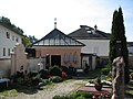
Obergnigl is part of the Gnigl district of the statutory city of Salzburg . The district on the outskirts still has a certain village character.
geography
Obergnigl is located in the northeast of the city, about 2½ kilometers from the city center, on the B158 Wolfgangsee Straße at the entrance to the Guggental , along the foot of Kühberg and Heuberg and the Alterbach . Obergnigl includes the more south-eastern locations of the old village Gnigl.
The boundaries of Obergnigl are the beginning of the Heubergstraße , the Minnesheimstraße (the beginning of the B158) , versorgunghausstraße - Andrä-Blüml-Straße - Ferdinand-Spannring-Straße - Neuhauserstraße , and the mountain foot of Kühberg and Heuberg.

|
.svg)
history

Neuhaus Castle was probably the turn of the 12th and 13th centuries. Built in the 14th century, it has been the property of the archbishopric and summer residence since the 14th century , and from 1508 the nursing court and later the regional court for the whole of the east up to Eugendorf and Schloss Ursprung . Gnigl became Hofmark .
In the Middle Ages, Obergnigl, which is close to the city, was particularly important as a mill location on the Alterbach , where, in addition to grain mills, there were also various forges and iron hammers . Several old mills in this mill village have been preserved, such as the Freyhammermühle (in Niedergnigl), the Gmahlmühle, Glockmühle, Sturmmühle, Kirchtagsmühle, Staudenböckmühle, Haselbachermühle or the Schnoderbacher Mühle . The first wooden water pipes have been running from here to the city of Salzburg since around 1485, which since 1488 has brought the water over the city bridge to the market fountain on what is now the Old Market.
The first chapel of St. Michael may have existed since the Middle Ages (documented in 1585), and today's parish church was built in 1731–38 . From 1699 (with Aigen ) parish curate, Gnigl became a parish in 1857.
In the course of the Middle Ages and early modern times, the route to Ebensee in the Salzkammergut (Salz) and the Styrian Erzberg ( Eisenstraße ) became important, the Grazer Reichsstraße or Ebenseer Straße , later, when the Salzkammergut became important as a tourist region, Wolfgangseestraße had to follow a steep steep step here Overcome Guggenthal. Only since the 1930s have there been two serpentines, known as bumpy turns . At the same time, the main road was also laid directly across the old Minnesheim Park (today's Minnesheimstrasse ).
In 1875 the Giselabahn (Salzburg-Tiroler-Bahn) was built, with which the local development began, in 1935 Gnigl came to Salzburg, in 1939 also the areas at Heuberg.
Today Obergnigl has largely grown together with the city, but has retained a certain village feel.
Transport and infrastructure
The main road traffic axis is the B158 Wolfgangsee Strasse , here Minnesheimstrasse - Grazer Bundesstrasse .
Obergnigl can be reached with the trolleybus lines 2 (stops at Reisenbichlerstraße, Volkschule Gnigl, Obergnigl ), and the bus lines 23 (Hauptbahnhof - Sam - Obergnigl, the latter two stops, partly also further on Fadingerstraße / Parsch) and 151 (Mirabellplatz - Obergnigl - Gaisbergspitze). The train bus , regional bus lines to St. Gilgen (course 150) also serve the district, stops Volksschule Gnigl and Salzburg Kühberg just before the city limits.
Culture and sights
- The parish church of St. Michael is a rococo church with an onion helmet, built 1731–1738 under Prince Archbishop Firmian . The first church probably came from the Middle Ages (documented in 1585). From 1697/98 a copy of the miraculous image of Maria Pötsch was shown and the church became a place of pilgrimage.
- The current cemetery was laid out in 1699 and expanded several times. In the mortuary chapel in the cemetery there is an All Souls' backdrop, the finely inscribed skulls are kept in wooden boxes.
- The Luggau Chapel (Our Lady on the Schnoderbach) was built after 1699–1701 on Guggenthalerstraße. A master miller had given the pledge to build the chapel in 1690 when the scaffolding collapsed, which did not cause permanent damage to the falling workers. The small altar there shows the picture of Maria Luggau (1690), which was first installed in a wall niche ( monument protection ).
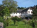
- Staudinger's art mill (originally Aumühle , also Mosermühle, Moosmühle, Staudingermühle , Mühlstr. 2-4) is located on the Alterbach, was first mentioned at the beginning of the 15th century in the land register of Neuhaus Castle and has a late Gothic core. The associated baroque chapel was built in 1730. The house with many remarkable construction details is connected to the actual, generously built mill via a covered walkway ( listed building ).
- The Minnesheim Park , the remains of the castle park . A group of figures worth seeing (The Four Seasons) is currently kept elsewhere.

Parish church
Cemetery with chapel

Luggau Chapel
Staudinger's art mill


.jpg)

Web links
proof
- Sabine Veits-Falk, Thomas Weidenholzer, Martin Zehentner (book design): Gnigl, medieval mill village, community on the railway, Salzburg district . Gnigler district chronicle. Self-published by the community development association Gnigl-Langwied-Sam, Salzburg 2010, ISBN 978-3-900213-13-8 .
- 50101 - Salzburg. Community data, Statistics Austria .
- ↑ Raphael Kleinsorg: Abriß der Geographie: For use in and outside schools. ... which contains the geography of Asia, Africa, America and Australia, along with an outline of the history and geography of the Archbishopric of Salzburg, and instructions on world and globe customers. tape 2 . Verlag Duyle, 1797, 2nd courts around the capital: 2) Nursing and regional court Neuhaus or Gnigl , p. 55 ( Google eBook, full view - complete edition p. 330).
- ↑ Route network and area maps , Salzburger Verkehrsverbund , svv-info.at (various maps, pdf)
- ↑ see bus route 150 . In: Salzburger Nachrichten: Salzburgwiki .
_COA.svg)
Cadastral communities (shares) : Gnigl
Settlement areas: Gnigl North • Neuhauserfeld • Niedergnigl • Obergnigl
Other locations: Neuhaus Castle • Gnigl marshalling yard
Counting districts: (shares) : Gnigl / Langwied | Sam / Kasern