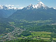
Kneifelspitze
| Kneifelspitze | ||
|---|---|---|
|
Kneifelspitze in front of the Untersberg massif |
||
| height | 1189 m above sea level NHN | |
| location | Untersberg massif , Upper Bavaria | |
| Mountains | Berchtesgaden Alps | |
| Coordinates | 47 ° 39 '30 " N , 13 ° 1' 3" E | |
|
|
||
The Kneifelspitze is 1189 m above sea level. NHN high, southeastern foothill of the Untersberg massif of the Berchtesgaden Alps in Upper Bavaria ( Germany ).
Geographical location
The densely wooded, flat-topped Kneifelspitze rises just under 3 km north-northeast from the center of the Berchtesgaden market between its suburbs of Untersalzberg in the south-east and Vordergern in the north-west.
The south-east foothills of the Kneifelspitze is the Kiliansberg .
summit
The summit of the Kneifelspitze can be reached from the famous Maria Gern pilgrimage church via an easy but steep hiking trail. There is a wonderful view of the Berchtesgaden valley with the Watzmann farmed Paul hut with the summit cross. In the opposite direction, the view extends to the Mozart city of Salzburg .
On the mountain is one of the six transmitter systems that serve as pseudolites in the GALILEO test and development environment (GATE) of the European satellite navigation system Galileo to simulate navigation satellites.


