Salzburg high throne
| Salzburg high throne | ||
|---|---|---|
|
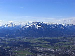
The Untersberg from the northeast; in the center of the picture the Salzburg high throne |
||
| height |
1852 m above sea level NHN 1853 u m. A. |
|
| location |
Bavaria , Germany State of Salzburg , Austria |
|
| Mountains | Untersberg , Berchtesgaden Alps | |
| Dominance | 2.5 km → Berchtesgadener Hochthron | |
| Notch height | 174 m ↓ lunch slot | |
| Coordinates | 47 ° 43 '5 " N , 13 ° 0' 17" E | |
|
|
||
|
Summit cross of the Salzburg high throne |
||
The Salzburger Hochthron is 1852 m above sea level. NHN is the second highest peak of the Untersberg massif in the Berchtesgaden Alps after the Berchtesgadener Hochthron .
geography
The summit of the Salzburger Hochthron is located on the border between the municipality of Grödig in the State of Salzburg , Austria and the municipality-free area of Schellenberger Forst in Bavaria , Germany .
The mountain station of the Untersbergbahn is located around 500 meters north of the summit on Geiereck ( 1805 m ) .
Ascent
In addition to the short boarding of the Untersbergbahn several marked walkways lead to the summit of Salzburg Hochthron, these require surefootedness and good physical condition:
- from Marktschellenberg via the Toni-Lenz-Hütte (approach to the Schellenberger ice cave ) and the Thomas-Eder-Steig via the Mittagscharte
- from Glanegg near Grödig via the Dopplersteig and the Zeppezauerhaus
- from Glanegg over the Reitsteig and the Zeppezauerhaus
- from the Stöhrhaus via Berchtesgadener Hochthron , Mittagscharte and Untersberg plateau
literature
- Bernhard Kühnhauser: Alpine Club Guide Berchtesgaden Alps with Hochkönig . 20th edition. Bergverlag Rother , Munich 2011, ISBN 978-3-7633-1127-9 .
Web links
- Salzburger Hochthron on Peakbagger.com (English)
- Route description for the ascent over the Thomas-Eder-Steig


