
Lattengebirge
| Lattengebirge | ||
|---|---|---|
 Lattengebirge from the north |
||
| Highest peak | Karkopf ( 1738 m above sea level ) | |
| location | Bavaria | |
| part of | Berchtesgaden Alps | |
|
||
| Coordinates | 47 ° 41 ′ 0 ″ N , 12 ° 53 ′ 0 ″ E | |

The Lattengebirge is one to 1738 m above sea level. NN high subgroup of the Berchtesgaden Alps in the Berchtesgadener Land district , Bavaria ( Germany ). It forms the northern end of the Berchtesgaden Alps.
geography
Geographical location
The Lattengebirge lies northeast of the Reiteralm , from which it is separated by the Schwarzbachwacht pass , and west of the Untersberg , from which it is separated by the Hallthurm pass . It is located in the area of the communities of Ramsau , Bischofswiesen , Bayerisch Gmain , Bad Reichenhall and Schneizlreuth , as well as in the formerly community-free areas (now districts of the respective communities) Forst Taubensee (Ramsau), Forst St. Zeno (Bayerisch Gmain, Bad Reichenhall and Schneizlreuth) and Bischofswiesener Forst (Bischofswiesen), and extends within the Berchtesgaden Biosphere Reserve . The Saalach , which is a south-westerly tributary of the Salzach , runs northwest past the Lattengebirge in a southwest-northeast direction .
summit
The highest peak of the Lattengebirge is the Karkopf ( 1738 m ). Important tour peaks are Predigtstuhl ( 1613 m ) with the Berghotel, Dreisesselberg ( 1680 m ), Toter Mann ( 1392 m ), Dötzenkopf ( 1001 m ) and Spechtenköpf ( 1285 m ).
Landscape and geology
The Lattengebirge consists mainly of Dachstein limestone and Ramsaudolomite , with the dolomite containing various proportions of magnesium . Since the rocks weather differently, bizarre rock shapes have formed in the Lattengebirge; Among other things, the stone Agnes (approx. 1400 m ), the rugged rocks below the Predigtstuhlbahn and the eye-catching formation of the Rotofentürme at the east end of the Lattengebirge. These are popularly known as the Sleeping Witch or Montgela's nose . Less well-known is the Teufelsloch, about 1585 m high , a natural rock gate about 5 m long with a diameter of around 2.5 m in a hump-like elevation on the south-east running ridge between the Sleeping Witch and the Alpgarten. Through this the sun is visible from the valley on certain days.
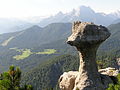
Stone Agnes, behind the Watzmann
Sleeping witch and sermon chair from the Reichenhaller house

Rotofen Towers

Devil's hole (center)


Tourism and development
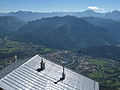
From Bad Reichenhall you can take the Predigtstuhlbahn to the mountain hotel on the Predigtstuhl. The cable car from 1928 is the oldest originally preserved large cable car in the world.
The Stadtberglift led from Loferer Strasse near the festival site to below the Spechtenköpfe at a height of around 900 m. The facility, built in 1955, was demolished in the 1990s.
The Hochschwarzeck ski areas near Ramsau and Götschen near Bischofswiesen-Loipl are also located in the Lattengebirge .
Web links
Individual evidence
- ↑ Hundred Masterworks - The Most Beautiful Geotopes in Bavaria, Bavarian State Office for the Environment, 2012, ISBN 978-3-936385-89-2
- ↑ The DEVIL'S HOLE in the Lattengebirge in Berchtesgadener Land