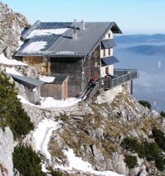
Reichenhaller house
| Reichenhaller Haus DAV hut category I |
||
|---|---|---|
| location | Bad Reichenhall municipality , below the Hochstaufen summit ; Bavaria , Germany ; Valley location: Bad Reichenhall , Piding | |
| Mountain range | Chiemgau Alps | |
| Geographical location: | 47 ° 45 '18.2 " N , 12 ° 50' 58.6" E | |
| Altitude | 1750 m above sea level NHN | |
|
|
||
| owner | DAV - Bad Reichenhall section | |
| Built | 1902 | |
| Construction type | hut | |
| Usual opening times | Mid May to mid October | |
| accommodation | 6 beds, 24 camps | |
| Web link | Reichenhaller house | |
| Hut directory | ÖAV DAV | |
The Reichenhaller Haus (often also called Staufenhaus ) is located 1750 m above sea level in the Chiemgau Alps, just below the summit of the Hochstaufen . The alpine club hut, which is managed during the summer months, is an important base for numerous mountain tours and climbing routes. It is the highest hut in the Chiemgau Alps with a wide view of Salzburg , the foothills of the Alps , the Salzkammergut mountains and the Berchtesgaden Alps . A special experience is the sunset behind the Chiemsee and the sunrise over the Salzkammergut .
history
In the middle of the 17th century mining was carried out on the Staufen near the peaks. It can be assumed that at least modest accommodation existed; however, nothing is known about it.
What is certain is that in 1902 a “modest shelter hut” was built on the Staufen summit. In 1908 this simple shelter was replaced by the toboggan hut, which was previously on Lochbründl (ascent to Zwiesel ). In the following year, the then landlord received the liquor license and in 1910 the next renovation was due: Due to difficulties with the hunter on the north side of the Staufer, the hut had to be moved to the south side, whereby eight additional beds were created. The hut remained closed from 1914 to 1918.
From 1925 to 1928 the hut was rebuilt in a different location after several break-ins caused great damage through the hut roof. A telephone line was also laid to the hut. The fresco "Die Stoanernen Jaga" ( The Stone Hunters ) in the guest room was created by the Reichenhall painter Franz Murr . A violent earthquake loosened the summit rocks in autumn 1928, whereupon a rock fall severely damaged the shell of the neighboring Staufenkapelle in the following year . Nevertheless, the chapel was consecrated in June 1929.
In 1974 the hut was given its present form during a renovation. In 1979 the rainwater collection system was completely renewed. The not harmless hut lighting with gas and candles was made superfluous in 1989 by a photovoltaic system.
On September 23, 1993, the innkeepers at the time were victims of robbery and murder.
The hut is supplied with drinks and canned food supplies by helicopter. All other groceries are carried up to three times a week by the hut keeper in a traditional wooden crate over the north climb secured with ropes to the hut, as there is no material cable car leading to the hut.
Accesses
- From the Padinger Alm (670 m, parking lot) near Bad Reichenhall via the Bartlmahd, medium, walking time: 3 hours
- From the Padinger Alm (670 m, parking lot) near Bad Reichenhall via the "Steinernen Jäger" ( difficulty level I according to UIAA, partially secured), walking time: 3 hours
- From Staufeneck Castle (500 m, near Piding ) over the Fuderheuberg and the Steinernen Jäger, walking time: 4 hours
- From Aufham (550 m) near Anger via the Steiner Alm and the northern flank, medium, walking time: 4 hours
- From Gasthaus Adlgaß (800 m, parking lot) near Inzell over the Frillensee and the northern flank, medium, walking time: 4 hours
- From Jochberg (850 m, parking lot) near Schneizlreuth via Querweg and Bartlmahd, medium, walking time: 3.5 hours
Transitions
- Zwieselalm (1,390 m, private) via Bartlmahd and Querweg, medium, walking time: 2 hours
- Zwieselalm via Mittelstaufen and Zennokopf, difficulty level I according to UIAA, partially secured, walking time: 3.5 hours
Mountaineering
- Hochstaufen ( 1772 m ), medium, walking time: 5 minutes
- Mittelstaufen ( 1657 m ), medium, partially secured, walking time: 45 minutes
- Ridge crossing Mittelstaufen - Zennokopf - Zwiesel ( 1782 m ), difficulty level I according to UIAA, partially secured, walking time: 3 hours
- Pidinger via ferrata through the northern slopes of Hochstaufen; (difficult via ferrata (C / D)), climbing time: 3 hours
literature
- Heimatblätter (as a supplement to the Reichenhaller Tagblatt) of October 4, 1973: 100 years of the Bad Reichenhall Alpine Club section (with the history of the Staufenhütte and the Reichenhaller Haus )
- Maps: TKU 4, AVF Chiemgauer Alpen, WF Chiem
- Festschrift 100 years of the Staufenhaus . Available from the section
- The Staufenhaus over the past century. In: 125 years of the DAV section Bad Reichenhall. 2000 ( PDF )
- Hut land register from 1908 ( digitized version )
Web links
- Section Bad Reichenhall in the DAV
- Reichenhaller Haus in the historical Alpine archive of the Alpine clubs in Germany, Austria and South Tyrol (temporarily offline)
Individual evidence
- ↑ The murder on the Hochstaufen near Bad Reichenhall , Chiemgau-Blätter from October 28, 2006, supplement to the Traunsteiner Tagblatt on traunsteiner-tagblatt.de, accessed on September 11, 2018


