
Pidinger via ferrata

The Pidinger Klettersteig is a demanding via ferrata that leads from Piding in the north face of Hochstaufen to just below the summit (1,771 m). It was built in 2003 under the direction of Sepp Reichenberger and in the upper part it follows an old climbing route that Willo Welzenbach first climbed in 1921.
Walking times
- Piding ( Urwies , parking lot approx. 450 m) to the entrance (approx. 1,020 m): approx. 1.5 hours
- Entry to the summit (1,771 m): approx. 2 - 4 hours (depending on condition / ability; longer on weekends with a lot of people!)
- Summit to Piding (Urwies): approx. 2.5 h (descent via normal route)
difficulty
Difficult and steep via ferrata, sometimes very vulnerable to falling rocks, sometimes very slippery in the lower area. Difficulty level C / D. Surefootedness , a head for heights and a good physical condition are required, via ferrata sets and rockfall helmets are strongly recommended. Although the climb has not been around for long, there have already been several mountain rescue missions and fatalities.
route
Entry: 47 ° 45 ′ 35 ″ N , 12 ° 51 ′ 12 ″ E
The starting point is Piding , Urwies district. From the large parking lot for hikers, the way to the entrance is well signposted. With the exception of a few passages, the via ferrata is almost entirely secured with steel cables, otherwise cairns show the way. The best way to descend is via the normal route towards the Steiner Alm, alternatively via the Steinernen Jäger to the Mairalm. It is forbidden to descend on the via ferrata.
photos
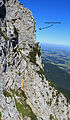
seen from the descent route
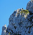
Via ferrata seen from the Steinerner Jäger

Pidinger via ferrata
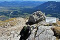
The exit on the Pidinger via ferrata
.JPG)
.jpg)
.JPG)
.JPG)
Web links
- www.via-ferrata.de (route description, photos, current comments)
- www.bergstieg.com (route description, photos, topography)