Zwieselalm (Bad Reichenhall)
| Zwieselalm | ||
|---|---|---|
|
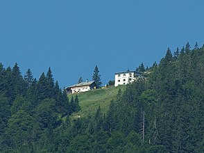
Zwieselalm with Kaiser-Wilhelms-Haus |
||
| location | Bad Reichenhall , Upper Bavaria | |
| Mountains | Staufen , Chiemgau Alps | |
| Geographical location | 47 ° 44 '51 " N , 12 ° 48' 50" E | |
|
|
||
| Form of ownership | Private valley | |
| height | 1386 m above sea level NN | |
| surface | 8 ha | |
| Waters | Water supply scarce, no well | |
| climate | warm | |
| flora | Heavily petrified and overgrown | |
| use | Hospitality and accommodation; no agricultural use | |
The Zwieselalm is an alpine pasture in the area of the town of Bad Reichenhall am Zwiesel in the Chiemgau Alps .
The Kaser of the Zwieselalm as well as the mountain accommodation, the "Kaiser-Wilhelm-Haus", are under monument protection and are registered in the Bavarian monument list under the number D-1-72-114-192 .
Building description
The Kaser of the Zwieselalm is a ground floor saddle roof building with boarded gable, which was built in the 18th century.
The mountain accommodation, the so-called "Kaiser Wilhelm House" on the Zwieselalm, is a two-story, massive monopitch roof building from 1897.
Todays use
The Zwieselalm has not been used for agriculture since 1975. Today, the owner family runs a restaurant and accommodation business on an irregular basis during the summer months.
location
The Zwieselalm is located in the Chiemgau Alps below the Zwiesel at an altitude of 1386 m above sea level. NN .
Tourist use
The Kaser of the Zwieselalm is a privately run alpine hut at an altitude of 1386 m above Bad Reichenhall . The Zwieselalm is an easily accessible, popular excursion destination and offers a great view of the Berchtesgaden Alps and the Bad Reichenhaller Saalachtal. The hut is only managed in the summer months and offers overnight accommodation for up to 60 people in the Kaiser Wilhelm House next door . For day visitors, the Zwieselalm is a welcome rest stop, for mountaineers it serves as a base on the Maximiliansweg that passes here .
Accesses
- From Jochberg near Schneizlreuth (840 m, parking lot) via the Hüttenweg, easy, walking time: 1.5 hours
- From Karlstein near Bad Reichenhall (680 m, parking lot) via the Zwieselweg, easy, walking time: 2.5 hours
- From the Padinger Alm near Bad Reichenhall (670 m, parking lot) via Bartlmahd, easy, walking time: 3 hours
- From Einsiedl (Inzell) near Inzell (740 m, parking lot) via the Kohleralm and the Höhenweg, easy, walking time: 2.5 hours
Transitions
- Reichenhaller Haus (1750 m, DAV) via Bartlmahd, medium, walking time: 2 hours
- Reichenhaller Haus via Zennokopf and Mittelstaufen, difficult, walking time: 3.5 hours
Mountaineering
- Zennokopf (1756 m) over the southern flank, easy, walking time: 1 hour
- Zwiesel (1,782 m) over the southern flank, easy, walking time: 1.25 hours
- Gamsknogel (1752 m) over the Zwiesel, medium, walking time: 2 hours
- Hochstaufen (1772 m) via Bartlmahd, medium, walking time: 2 hours
Web links
- Hike to the Zwieselalm
- Zwieselalm . In: Agricultural and cultural heritage database . Society for Agricultural History
Individual evidence
- ↑ Zwieselalm - Flora on agrarkulturerbe.de, accessed on September 23, 2019

