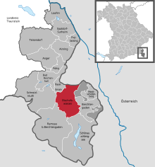
Bischofswiesen forest
The Bischofswiesener Forst was a community-free area in the Berchtesgadener Land district . It was dissolved with effect from January 1, 2010 and incorporated into the communities of Bischofswiesen , Bayerisch Gmain and Berchtesgaden .
As of January 1, 2009, the area covered an area of 29.4591 km 2 . The largest part (27.6767 km² or 2767.67 hectares or 93 percent) went to the community of Bischofswiesen and continues in it as the district of Bischofswiesener Forst . 93.54 hectares were added to the Maria Gern district of the Berchtesgaden market, and the remaining 84.70 hectares to the Bayerisch Gmain community and district.
In the north-west of the area is the Steinbergsee and the Steinerne Agnes , in the north the Hagenfels castle stable , and in the north-east the giant thing shaft cave .
Area statistics
According to the 2001 area survey, the types of use in the former municipality-free area are broken down as follows:
| Land use according to ALB 31.12.2001 |
Hectares | percent |
|---|---|---|
| 700 forest area | 2070.02 | 70.27 |
| 950 unland | 801.65 | 27.21 |
| 600 agricultural area | 53.80 | 1.83 |
| 500 traffic areas | 13.05 | 0.44 |
| 800 water surface | 7.13 | 0.24 |
| Building and open space | 0.02 | 0.01 |
| total | 2945.83 | 100.00 |
Picture gallery
View from Jenner to Bischofswiesen and the Bischofswiesen forest
The Steinbergsee
The Stone Agnes
Entry to the
giant thing shaft cave
Individual evidence
- ↑ Ordinance on the dissolution of the community-free area "Bischofswiesener Forst", district of Berchtesgadener Land, and reorganization of parcel No. 94/1 of the district of Bischofswiesener Forst from the area of Marktschellenberg, district of Berchtesgadener Land, to the area of the community of Bischofswiesen, district of Berchtesgaden Land of 9 December 2009 (RABl p. 191; PDF; 461 kB)
- ↑ GENESIS-Online Database Bavaria , Table 11111-003.
- ^ Bavarian State Office for Statistics
- ↑ Usage type key according to the AdV usage type directory from 1991
Web links
- Map with district boundary (Bischofswiesen forest in the municipality of Bischofswiesen)
Coordinates: 47 ° 41 ′ 58.6 ″ N , 12 ° 57 ′ 56.9 ″ E


