
Durnagel
|
Durnagel Durnagelbach |
||
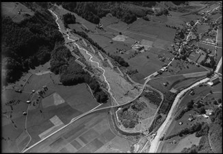 The mouth of the Durnagels with the village of Linthal in 1953 |
||
| Data | ||
| Water code | CH : 2507 | |
| location | Switzerland | |
| River system | Rhine | |
| Drain over | Linth → Limmat → Aare → Rhine → North Sea | |
| source | at the rear Sulzhorn 46 ° 52 '36 " N , 9 ° 2' 10" O |
|
| Source height | approx. 2110 m above sea level M. | |
| muzzle | in the Linth near Linthal Coordinates: 46 ° 55 '49 " N , 9 ° 0' 17" E ; CH1903: 719 254 / 198 871 46 ° 55 '49 " N , 9 ° 0' 17" O |
|
| Mouth height | 633 m above sea level M. | |
| Height difference | approx. 1477 m | |
| Bottom slope | approx. 19% | |
| length | 7.9 km | |
| Catchment area | 18.77 km² | |
| Discharge at the mouth of the A Eo : 18.77 km² |
MQ Mq |
1.27 m³ / s 67.7 l / (s km²) |
| Right tributaries | Wolfisbach | |
| Communities | Glarus South | |
The Durnagel is an approximately 8 kilometer long right tributary of the Linth in the Swiss canton of Glarus , which flows through the Durnachtal .
course
The Durnagel rises on a small firn at about 2110 m above sea level. M. below the mountain ridge between Scheidstöckli and Hinter Sulzhorn . Initially flowing to the north-east through debris from the valley, it soon reaches the moraine of the Hinterer Sulgletscher , which is covered by an alpine pasture and into which it has cut. After a short run through layers of nummulite , a small waterfall follows, after which the stream reaches the valley floor and now mostly flows to the northwest. At the same time, the glacier's more water-rich drainage flows into it, and only a short time later the rear Durnach valley opens. Here it is bordered by several alpine meadows, which are bordered by wooded mountain slopes . The valley floor through which it flows consists mostly of rubble and alluvial soils .
At the Stäfeli alpine hut , part of the water is extracted. The stream then cuts deep into the valley floor, and from now on it is tamed by 82 barriers . It takes up the Wolfisbach from the right and now flows through the Vordere Durnachtal in a north-westerly direction. The Breitzungwald now stretches on the left bank , while on the right bank a narrow forest line stretches along the valley floor, over which there are several alpine meadows. The Berg alpine hut follows , after which a small, heavily forested gorge follows. At the Syten farm it reaches the Linthal and forms a wide alluvial cone . After crossing under main road 17 at three points, the Durnagel flows between the villages of Linthal and Rüti at 633 m above sea level. M. from the right into the upper reaches of the Linth flowing north.
Individual evidence
- ↑ a b c Geoserver of the Swiss Federal Administration ( information )
- ↑ a b Topographical catchment areas of Swiss waters: sub-catchment areas 2 km². Retrieved September 24, 2017 .