Tödi
| Tödi | ||
|---|---|---|
|
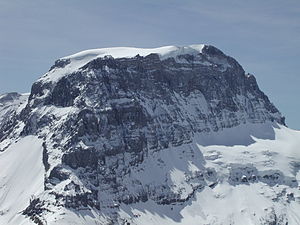
Tödi, view from the Gemsfairenstock |
||
| height | 3614 m | |
| location | Canton of Glarus / Canton of Graubünden , Switzerland | |
| Mountains | Alps ( Glarus Alps ) | |
| Dominance | 42.05 km → Dammastock | |
| Notch height | 1570 m ↓ Oberalp Pass | |
| Coordinates | 712655 / 185498 | |
|
|
||
| First ascent | September 1, 1824 by A. Bisquolm and P. Curschellas | |
| Normal way | From the Fridolinshütte over the Bifertenfirn to the summit | |
The Tödi ( also called in Romansh ) is the highest peak in the Glarus Alps . The border between the Swiss cantons of Glarus and Graubünden runs over the summit . It is heavily glaciated and difficult to access. The Tödi is divided into the three peaks of Piz Russein ( 3614 m above sea level , west summit), Glarner Tödi ( 3577 m above sea level , east summit) and sand summit ( 3388 m above sea level , north summit), which are only indistinctly protruding from a distance ).
geography
The Tödi is delimited in the west by the Sand Pass ( 2781 m above sea level ), in the south by the Val Russein, which belongs to the catchment area of the Vorderrhein , in the east by the Bifertenfirn and in the north by the Sand valley, which flows from a source brook of the Linth is drained. The Tödi has very steep slopes on three sides, especially towards the Val Russein. Below these flanks are smaller firn fields, including the Sandfirn, the Vordere Rötifirn and the Hintere Rötifirn. To the east extends the Bifertenfirn, a 4 km long glacier with numerous crevices, which originates on the glaciated summit of Piz Russein.
The Tödi has two secondary peaks of the same name: the Kleine Tödi (Romansh: Crap Glaruna ), a 3,076 m above sea level. M. high crag west of the mountain, as well as the Bündner Tödi (Romansh: Tödi Grischun ), a 3124 m above sea level. M. high mountain between the Tödi and the Bifertenstock .
It is believed that the name comes from the Swiss German "d'Ödi" (the desert - uninhabited, desert-like area) and became Tödi over time.
geology
Geologically, the base of the Tödi belongs to the easternmost part of the Aar massif . The apex is discordant over this old crystalline basement . At the foot of the apex is the Rötidolomite from the Triassic epoch , a striking, approximately 50 m thick red-yellow band. This is followed by limestone from the Jurassic period , in particular Schilt, Quintner and coral limestone.
Approach

The Benedictine Father Placidus a Spescha from Disentis (1752-1833) made several attempts around 1800 to climb the Tödi. He made the last attempt on September 1, 1824 together with P. Curschellas and A. Bisquolm. While the father did not make it to the summit for reasons of age, the latter successfully completed the first ascent . The ascent took place from Graubünden through the Val Russein and probably through the Porta da Spescha.

Today's normal route leads from the 2111 m above sea level. M. Fridolinshütte (operated by the Swiss Alpine Club SAC) located on the eastern slope near the glacier tongue of the Bifertenfirn via the Grünhornhütte (the first SAC hut to be preserved only as a museum) along the Bifertenfirn over the yellow wall, then the rest of the path continues the glacier to the summit of Piz Russein.
The easiest and most common Tödi ascent today leads from the south via the Punteglias hut and the Porta da Gliems to the uppermost Bifertenfirn.
See also
literature
- Emil Zopfi: Tödi - longing and dream. In: Emil Zopfi (Ed.): Mountain monographs. Volume 5. AS Verlag & Buchkonzept, Zurich 2000, ISBN 3-905111-49-7 .
Web links
- Karin Marti-Weissenbach: Tödi. In: Historical Lexicon of Switzerland .
- Tödi - Piz Russein 3614 m. In: hikr.org. Tour reports.

