
Kops reservoir
| Kops reservoir | |||||||
|---|---|---|---|---|---|---|---|
 |
|||||||
|
|||||||
|
|||||||
| Coordinates | 46 ° 58 '20 " N , 10 ° 7' 10" E | ||||||
| Data on the structure | |||||||
| Lock type: | Main wall: arch dam with one natural and one artificial abutment, side wall: gravity dam | ||||||
| Construction time: | 1962-1969 | ||||||
| Height above the river bed : | > 90 m | ||||||
| Height of the structure crown: | 1813 m | ||||||
| Base width: | 30 m | ||||||
| Power plant output: | 245 + 525 MW | ||||||
| Operator: | illwerke vkw AG | ||||||
| Data on the reservoir | |||||||
| Altitude (at congestion destination ) | 1809 m above sea level A. | ||||||
| Water surface | 1 km² | ||||||
| Storage space | 42.9 million m³ | ||||||
| Catchment area | 170 km² | ||||||

The Kops reservoir is located in the Austrian Alps in the state of Vorarlberg on the border between Silvretta and Verwall . It has a usable capacity of 42.9 million cubic meters , which corresponds to an energy content of 127.45 million kilowatt hours .
location
When the reservoir is fully flooded, the water level is just below the Zeinisjoch (1842 m) at an altitude of 1809 m above sea level. A.
history
The Kops reservoir is a reservoir owned by the illwerke vkw and was built from 1962 to 1969. The first full dam took place in November 1967, when the main dam arched by up to 55 mm. It is the storage facility for the Kopswerk I, which went into operation in 1969, and the much more powerful Kopswerk II, which was completed in 2009 and is connected via a separate tunnel .
Water supply
|
Power plant group Obere Ill-Lünersee |
|||||||||||||||||||||||||||||||||||||||||||||||||||||||||||||||||||||||||||||||||||||||||||||||||||||||||||||||||||||||||||||||||||||||||||||||||||||||||||||||||||||||||||||||||||||||
|---|---|---|---|---|---|---|---|---|---|---|---|---|---|---|---|---|---|---|---|---|---|---|---|---|---|---|---|---|---|---|---|---|---|---|---|---|---|---|---|---|---|---|---|---|---|---|---|---|---|---|---|---|---|---|---|---|---|---|---|---|---|---|---|---|---|---|---|---|---|---|---|---|---|---|---|---|---|---|---|---|---|---|---|---|---|---|---|---|---|---|---|---|---|---|---|---|---|---|---|---|---|---|---|---|---|---|---|---|---|---|---|---|---|---|---|---|---|---|---|---|---|---|---|---|---|---|---|---|---|---|---|---|---|---|---|---|---|---|---|---|---|---|---|---|---|---|---|---|---|---|---|---|---|---|---|---|---|---|---|---|---|---|---|---|---|---|---|---|---|---|---|---|---|---|---|---|---|---|---|---|---|---|---|
|
|||||||||||||||||||||||||||||||||||||||||||||||||||||||||||||||||||||||||||||||||||||||||||||||||||||||||||||||||||||||||||||||||||||||||||||||||||||||||||||||||||||||||||||||||||||||
Since the reservoir is only a few meters below the top of the Zeinisjoch pass , it would naturally only be fed by a few small streams, which is why the power stations could only be supplied with very little water. Therefore, several streams that would actually flow into the Trisanna or the Rosanna and ultimately into the Danube are diverted through tunnels into the reservoir. The collected water of the Jambach and other streams of the Tyrolean Silvretta is pumped into the Kopssee by the Kleinvermunt pumping station near the Tyrolean tollbooth of the Silvretta High Alpine Road . The fact that water from Tyrolean streams is directed into the Kopssee and thus to Vorarlberg is due to the fact that the Montafon is a few hundred meters lower than the Paznaun valley and the water can thus be processed over significantly greater heights.
Including the transfers, the Kops reservoir has a catchment area of 170 km² and an annual water supply of 233 million m³.
Technical
The inflow and outflow for the Kopswerk I is about 90 m, that for the Kopswerk II at a depth of about 80 m below the full water level.
tourism
The Kops reservoir can be reached on foot or by bike through the Ganifer via an extremely steep, narrow road from Partenen in Montafon that is closed to general vehicle traffic . The bus stop at the Zeinisjochhaus is served from around mid-June to the end of September with line 260/4240 Landeck - Wirl - Bielerhöhe . In the rest of the time the line from Landeck ends in Wirl. There is a street from Galtür in Paznaun . A hiking trail leads around the lake. On the northern shore of the lake, near the dam, is the Kopser Stüble, a small inn that is open during the day in summer and early autumn. In the northeast of the reservoir lies the Zeinis foreland . The Zeinisjochhaus inn and a small campsite are located on its banks. In winter, a slope from the Galtür ski area is rolled on the road to the Kopssee.
Web links
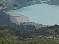
Kopssee from the southwest, from Breitspitz (2203 m)

Kops reservoir (view from the northwest, from the Gibaualpe)

Silvapark ski area with Kopssee


Individual evidence
- ↑ Information board of the Vorarlberger Illwerke at the reservoir above the north end of the arch dam
- ↑ Digital Austrian map.