
Brandner Glacier


The Brandner Glacier (also Schesaplana Glacier , older Brandner Ferner ) is located in the Rätikon in Austria . It is only a few kilometers wide or long. The Mannheimer Hütte is located next to the glacier . A path leads over the glacier to the ascent point on the Schesaplana summit. The path is safe, but unsafe in fog.
The natural runoff occurs in the block ice over the glacier brook (also named as it is) and the Alvier to the Ill , but also on the Schafjoch to the south over the Vals brook and Taschinasbach into the Landquart . The glacier is also connected to the Lünersee of the illwerke vkw through a tunnel ( beginning of the tunnel ) .
The Glingabrunnen is located south of Brand. This is fed by water brought in from the glacier underground and dried up from around November to May.
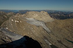
The glacier is framed (counterclockwise) by Wildberg , Panüelerkopf , Salaruelkopf , the Schafköpf and the Schesaplana . Furthermore (as of 2019) there was a separate, small ice field on the north slope of the saddle between Felsenkopf and Zirmekopf.
Historical photos in the restaurant of the Douglasshütte show that the glacier used to gush down over the saddle between Mannheimer Hütte and Panüeler Kopf into the Zalim Valley. It has melted again massively in the last few decades, according to measurements by Vorarlberger Illwerke AG by 20 m from 1990 to 2003 alone.
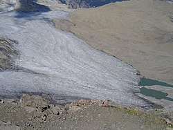
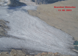
View from the summit of the Schesaplana over the Brandner Glacier to the Mannheimer Hütte on August 13, 2003

View from the summit of the Schesaplana over the Brandner Glacier to the Mannheimer Hütte on July 22, 2006
Comparison of the dimensions of the glacier between 2003 and 2006. A melting of the glacier is noticeable.

View from the summit of the Schesaplana over the Brandner Glacier to the Mannheimer Hütte on July 24, 2015

View of the Brandner Glacier from the summit of the Schesasplana on August 23, 2016

View from the summit of the Schesaplana over the Brandner Glacier to the Mannheimer Hütte on July 13, 2017. Further significant melting in recent years.
The pathetic remains of the Brandner Glacier, which has crumbled into several parts, as seen from the Schesaplana in early September 2019.


In the early 1980s, consideration was given to establishing a summer ski area on the glacier. Due to the costs, among other things for an avalanche-safe access, foreseeable unprofitability of the ski area, furthermore due to the increasing meltdown as well as protests from the population and alpine clubs, the project was dropped again. In addition, Vorarlberg anchored the absolute protection of glaciers as an instrument of Alpine spatial planning in its nature conservation legislation in 1981 and thus prevented such projects.
Web links
Individual evidence
- ↑ GKZ 81221615 according to Vogis water book. Retrieved November 26, 2014 .
- ↑ EN VIW power plant, Lünerseewerk. In: Excerpt from the water book. Office of the Vorarlberg state government, accessed on November 26, 2014 .
- ↑ Information sign at the Glingabrunnen
- ↑ Showroom (exhibition) in the Lünerseewerk
- ↑ a b Peter Haßlacher: Alpine spatial planning. YESTERDAY TODAY TOMORROW. (No longer available online.) In: Ländlicher Raum. Online trade journal of the Federal Ministry of Agriculture, Forestry, Environment and Water Management. 2007, p. 3 , archived from the original on December 25, 2014 ; Retrieved November 26, 2014 . Info: The archive link was inserted automatically and has not yet been checked. Please check the original and archive link according to the instructions and then remove this notice.
Coordinates: 47 ° 3 ′ 31 ″ N , 9 ° 42 ′ 1 ″ E