Schesaplana
| Schesaplana | ||
|---|---|---|
|
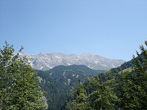
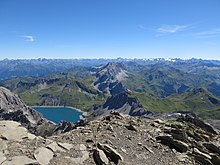
View from the Mannheimer Hütte to the Schesaplana and the remains of the Brandner Glacier |
||
| height |
2965 m above sea level A. 2964 m above sea level M. |
|
| location | Vorarlberg , Austria and Graubünden , Switzerland | |
| Mountains | Rätikon of the Alps | |
| Dominance | 30.25 km → Chlein Seehorn | |
| Notch height | 828 m ↓ Swiss Gate | |
| Coordinates , ( CH ) | 47 ° 3 '14 " N , 9 ° 42' 26" O ( 772 344 / 213920 ) | |
|
|
||
| rock | Kössen formation , main dolomite | |
| Age of the rock | Upper Triassic | |
| First ascent | 1730s by Nicolin Sererhard with two companions (tourist) | |
| Normal way | from the Lünersee via the Totalphütte | |
| particularities | Highest mountain in the Rätikon | |
|
Schesaplana from the Swiss side from Seewis. |
||
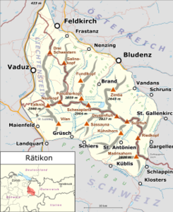
The Schesaplana (emphasized on -pla- ) is with a height of 2965 m above sea level. A. (according to Swiss measurements 2964 m above sea level ) the highest mountain in the Rätikon and still belongs to the Eastern Alps . Its name is made up of "Saxa" and "plana" ( Schrofen , the plan, straight is). Other names used earlier were "Sergia - plana" and "Scaessa Planna". The state border between the Austrian state of Vorarlberg and the Swiss canton of Graubünden runs over its summit . The Brandner Glacier is located on the northern slope, and the Lünersee is located at the eastern foot , with an area of 1.6 square kilometers (when fully jammed ) one of the largest mountain lakes in Vorarlberg. With a depth of approx. 139 m (with full damming) this is also the deepest mountain lake in the state.
geology
The Schesaplana massif forms the westernmost foothills of the northern limestone Alps . Thick layers with dolomitic plate and mass limestone are characteristic. In between there is the restless Raibl formation with thin layers of plaster of paris, clay marl and slate, which also stand out against each other in terms of color. In the summit area you finally find the Kössen layers, again with dark marls, individual limestone banks and black to brownish clay slates, all of which disintegrate easily and in small pieces.
History of ascent and tourist development
Some authors dated the first documented ascent of the Schesaplana as early as 1610. For example, the alpine club leader of Walther Flaig reports on an ascent on August 24, 1610. This is said to have taken place by the Bludenz bailiff David Pappus von Tratzberg with two guides as part of the border inspection of the lords of Bludenz and Sonnenberg. From a historical perspective, however, this is untenable on the basis of contemporary records.
In the "Urbar", a documentation from 1620 of the Bludenz and Sonnenberg lords, Captain David von Pappus described several of his official mountain trips to explore the borders as well as the possibilities of defense in an attack from today's Graubünden. Accordingly, he and his companions ascended from Vandans on August 24, 1610 through the Rellstal and over the Salonia / Zaluanda Alps to the Swiss Gate , from where they could take a first look over the border. The further route led over the Verajoch ( 2330 m ) into the area between Cavalljoch and Lünersee, where this yoke located in the borderline was also visited. Then they explored two ways from Totalp to Prättigau and finally visited “the high glacier in Brann”. This did not mean the Brandner Glacier or the Schesaplana summit, but the Schesaplana mountain range as a whole. The group turned around in the area of Totalp and reached neither the Brandner Glacier nor the Schesaplana. An ascent on this would not have been necessary to complete Pappus' assignment. The descent took place on the same day, with the help of a shepherd who is said to have treaded a trail from the Lünersee over the Lünerkrinne ( 2155 m ) to the Alpe Lün, from which the path leads down to the Rellstal, into the fresh snow.
Given the fact that fresh summer snow was already lying at heights of around or a little over 2000 m, a Schesaplana ascent at the beginning of the 17th century within a day from Vandans (648 m) as the starting point, and also with the detour via the Verajoch, hardly seems possible .
The first documented ascent of the Schesaplana was carried out by the Prättigau pastor Nicolin Sererhard with two companions in the 1730s. He described his "Schaschaplana mountain rice" in his regional history work Einfalte Delineation of all communities of common three leagues in 1742 in detail. The three crossed the Schesaplana from Seewis to Brand . The ascent led over the Schafloch and the Brandner Glacier, the descent over the Totalp and the Lünersee. The further descent led over the Lünerseealpe and the Cavelljoch.
The next traditional ascent in 1790 was that of the Bludenzer Baron Franz Ludwig von Sternbach and the Brandner hunter Josef Sugg, which is considered the first ascent from Brand.
In 1793 the Graubünden politician Jakob Ulrich Sprecher von Bernegg, the aristocrat and poet Johann Gaudenz von Salis-Seewis, the pastors Luzius Pol von Fläsch and Jakob Valentin von Jenins, as well as two other people, climbed the Schesaplana on a route similar to Sererhard.
Luzius Pol von Fläsch climbed the Schesaplana again alone in 1809.
Another ascent report by Carl Ulysses von Salis-Marschlins is dated to 1811.
In the 1850s there was a kind of class trip when the Jesuit fathers of the Stella Matutina School in Feldkirch, founded in 1856, climbed with several of their students to the summit, where they are said to have been completely exhausted.
At the beginning of 1885 the first winter ascent without skis was made by the Swabian Theodor von Wundt with a companion from Brand.
On New Year's Day 1900, Victor Sohm, Josef Ostler and Hermann Hartmann reached the Schesaplana on skis. This was one of the first ski tours to a high summit in the Eastern Alps.
The Brandner Valley, once populated by Walsers , was quite remote for centuries. The few mountaineers active in the Schesaplana region were dependent on (at that time) primitive shepherds' huts, e.g. the Lünersee, Schattenlagant or Oberzalimalpe, or spent the night at the mountaineering-friendly pastor Georg Tiefenthaler in his office before the Lünerseehütte opened.
The first ascent of Piz Buin by Johann Jakob Weilenmann and companions in 1865 made mountaineering popular in Vorarlberg. So then z. For example, through the initiative of G. Tiefenthaler, in the 1860s, work to make the dreaded, and previously mostly avoided "Evil Step" easier to walk on, which overcomes the rock step between the uppermost Brandner Valley and the Lünersee - now also crossed by the cable car .
The commissioning of the railway line from the Rhine Valley to Bludenz in 1872 (altitude of the Bludenz train station approx. 560 m) and the Arlberg railway tunnel (1884) made the journey to the Brandner Valley much easier. Previously, in 1852, Weilenmann had walked 60 km from St. Gallen to Brand in one day, climbed the Schesaplana the next day and returned to St. Gallen on foot on the third day.
The transport system within the valley remained relatively backward. It was not until 1930 that a road was inaugurated, which also allowed the opening of a bus route to Brand ( 1037 m ).
In June 1871 , the Austrian Alpine Association (OeAV) opened one of the very first Alpine Association huts on the peninsula protruding into the Lünersee, the Lünerseehütte, built according to plans by the Vorarlberg industrialist and mountaineer of Scottish descent, John Sholto Douglass. After Douglass' death it was named after him from 1874. An avalanche destroyed the building in the winter of 1876/77. After the reconstruction in 1877, which was adapted to the danger of avalanches, during which the hut was already enlarged, it underwent further modifications and additions towards the end of the 19th century due to the increasing number of visitors.
"Hard tourism" was practiced as early as 1886 when it was "processed" with explosives in order to make room for the numerous visitors to the Schesaplana summit.
In 1889 there were already ten mountain guides in Brand.
In 1890, the Nenzing Küng brothers built the Strausssteig, named after the chairman of the Constance Alpine Club section at the time. Wilhelm Strauss suggested the construction of this path and supported it with a generous donation.
The Bludenz Alpine Club section set up the Schattenlaganthütte ( 1483 m ) in the upper Brandner Valley in 1897 , while the SAC opened the Schesaplanahaus ( 1908 m ) in 1898 .
Already in 1900 the Bregenz ophthalmologist and alpinist Karl Blodig (1856–1953) remarked about the development of the Schesaplana: "... no other summit of the same height in the Alps will be as pleasant and safe as that."
Furthermore, in 1903/04, a Tyrolean company laid out the Leibersteig, named after a former Strasbourg section chairman, Adolf Leiber, in preparation for the construction of the “ Straßburger Hütte ”. Explosives were also used. On August 14, 1905, the Strasbourg section inaugurated the hut located on the northern edge of the Brandner Glacier at an altitude of 2679 m . Since the ascent there from Brand through the Zalimtal and over the Leibersteig takes 5½ to 6 hours, the spontaneous decision was made to go to the Oberzalimhütte (also called Georg-Orth-Hütte), which is halfway at an altitude of 1889 m and which is in operation on the same day was taken to build. As a result of World War I, the Strasbourg section was dissolved in 1919. The Mannheim section acquired the Straßburger Hütte and Oberzalimhütte in 1920, renamed the former to Mannheimer Hütte , and operates both houses to this day (2017).
In 1930, the year the new road to Brand was opened, the Douglasshütte was expanded again.
According to a newspaper report, a total of 1,000 people were on the Schesaplana on August 14 and 15, 1932.
After the Second World War, the electricity company “Vorarlberger Illwerke AG” built a dam on the north side of the Lünersee in order to considerably increase the capacity of what was once the largest natural high mountain lake in the Eastern Alps. To do this, they built a factory cable car from the head of the Brandner Valley ( 1565 m ) to the Seebord, the rock bar that borders the Lünersee to the north. Since the Douglasshütte was to be expected to flood when the first full damming occurred in 1959, it was torn down beforehand and a larger replacement building, the current Douglasshütte, was built in an avalanche-proof location directly at the mountain station ( 1979 m ). 144 beds are currently available there (as of 2016).
After completion of the dam, the Illwerke converted the works cable car into an aerial tramway for the public. In 1959 a 30-person cabin was first used, in 1962 one for 50 and currently one for 47 people. The train can transport 335 people per hour and direction. By the end of the 2015 operating season, the railway had carried 9.65 million people. In addition, the valley station can also be reached by bus 81 during the operating times of the cable car (around the second half of May to around mid-October). The walking time to the Schesaplana was reduced to 3½ hours.
Finally, in 1978/79, the tenants of Totalp and Mannheimer Hütte, supported by the Austrian customs guard, which carried out blasting work, built the Südwandsteig .
In order to channel the water from the Brandner Glacier into the Lünersee, the Illwerke drove a tunnel through the ridge that descends from the Schesaplana to the east. The building barrack set up on the north-eastern edge of the Totalp was the initial structure for the current “ Totalphütte ” of the PES, which has been expanded and rebuilt several times , which is located at an altitude of 2385 m on the Lünersee - Schesaplana route and is cultivated in summer. From here the summit can be climbed in 2 hours.
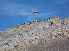
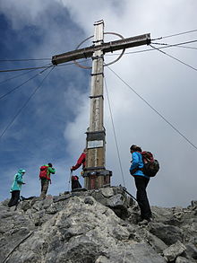
Together with the Schesaplana hut there are five huts that are managed in summer, from which the Schesaplana can be reached on a day tour. Fittingly, there is room for a few dozen people at the same time under its 9.5 m high summit cross. The Catholic youth Hörbranz built this in 1949 and dragged 2 tons of material to the summit. After lightning fell the cross in 1971, she rebuilt it in 1973.
Outside the operating hours of the cable car, it is often pleasantly quiet in the extensive area around the Lünersee. In the winter months, the road from Brand to the valley station is closed to general vehicle traffic and, if the conditions are right, it is made into a toboggan run. If the weather and snow conditions are favorable, you can meet at least several dozen winter mountaineers in the Schesaplana area on weekends. The Totalphütte offers a winter room with around ten beds. The winter room of the Douglasshütte was closed after the OeAV sold the house to the Illwerke.
Plans to set up a year-round ski area on the Brandner Glacier were abandoned as a result of protests from the population, the Alpine clubs, and negative environmental impact reports. Most recently, in 1983, the "Austrian Institute for Spatial Planning" certified the project as having major disadvantages for nature and rated it as unprofitable, which sealed the end of the ski area.
Climbs
The summit of the Schesaplana can be reached on foot from several sides, including the following paths:
- from fire to the (in places endangered by falling rocks) " Böse Tritt ", the Douglasshütte on the Lünersee and the Totalphütte
- from Brand through the Zalimtal (variant possible over the shady " Glingaweg "), over the Leiber or Strausssteig (and the Mannheimer Hütte ) over the Brandner Glacier
- from Switzerland over the Schesaplanasattel from the Schesaplanahütte (so-called " Schweizersteig "), over the "Frick" and "Liechtensteiner Weg" as well as over the Cavelljoch and Gamsluggen passes.
The almost seven-hour ascent from Brand through the Zalimtal, the Leibersteig (possibly with a detour to the Mannheimer Hütte) and over the Brandner Glacier is difficult due to the snow fields on the north-facing steep terrain above around 2300 to 2400 m that often exist well into summer and only recommended for experienced mountaineers. The long ascent from the Nenzing sky over the Spusagang and the Strausssteig, which is sometimes very exposed and secured with ropes (again with a detour to the Mannheim Alpine Club) and the Brandner Glacier, requires high-alpine expertise. The Strausssteig is even more challenging than the Leibersteig. In mid-October 2015, a mountaineer was torn down by a slab of snow 400 m over extremely steep terrain. According to a statement made in 2018 by the tenant of the Mannheimer Hütte, renovation of the path is planned. There are cross-connections so that the glacier can also be reached from Brand via the Strausssteig and from the Nenzinger Himmel via the Leibersteig.
The thickness of the Brandner Glacier, which, as can be seen in old photos hanging in the Douglass- and Mannheimer Hütte, formerly reached just below the Straßburger- / Mannheimer Hütte, has since shrunk considerably, according to measurements by the Illwerke between 1990 and 2003 alone at 20 m. The glacier traversing that once ran from the hut to the south-southeast directly to the Schesaplana saddle was relocated. Nowadays, the glacier crossing, to which you first have to descend about 80 meters from the alpine club house, runs south-south-west to the ridge of the Schafköpfe, over which you can get east to the Schesaplana saddle. In various tour descriptions it is often claimed that the crossing is free of gaps. However, in the area around the well-traveled route, isolated crevices can be found.
Another long, demanding approach from Salaruelfurka, the “Liechtensteiner Höhenweg”, begins at the Pfälzer Hütte in Liechtenstein . It leads, always close to the western Rätikon main ridge, partly secured with a rope, to the Schaflochsattel ( 2713 m ) above the western tip of the Brandner Glacier. From there you can climb to the summit via the Schafköpfe and the Schesaplanasattel ( 2739 m ).
The “Schweizersteig”, the ascent from the Schesaplanahütte over the Schesaplana saddle and the southwest flank, is also challenging.
There is also an ascent from the Schesaplanahütte to the Liechtensteiner Höhenweg via the Frickweg, which can be reached at Salaruelfurka or at the point 2499 m below the Black Saddle ( 2662 m ).
The ascent from Switzerland to the “Gamsluggen” pass ( 2380 m ), over which the national border runs, is also challenging . From there, the path crosses the Totalp and meets the path from Lünersee and the Totalphütte at a height of 2600 m . Crossing the Totalp, which slopes slightly from west to east, is not very demanding in terms of mountaineering. The almost vegetation-free lunar landscape of the Totalp, formed from hundreds of similar humps, hills, valleys, ditches and rubble heaps, makes orientation in fog almost impossible for non-residents.
The southern ascent from Lünersee is significantly easier, but it still requires good surefootedness . There are also several wire rope passages on this ascent (above 2750 m ).
A cross connection through the rubble-covered northern flank of the Kanzelköpfe saves you an intermediate descent on the Cavalljoch - Totalphütte path down to the Lünerseerundweg.
Finally, the promising Südwandsteig should be mentioned. This crosses the steep southern flank of the Schesaplana south shoulder at a height of approx. 2700 to 2800 m and allows a transition from the Schesaplana saddle to the Totalp without crossing the saddle between the south shoulder (approx. 2910 m ) and the main summit, which is marked with a border board . This path is secured with wire ropes. When the conditions are favorable, its ascent requires surefootedness and careful attention to falling rocks from the south shoulder. If the numerous steep gullies crossed by the path are filled with snow, however, it is much more difficult to pass the path.
There is also a winter path that is still marked on some maps. It begins in the winter area of the Totalphütte, leads in a southerly arc over the Totalp and joins the Gamsluggen – Schesaplana trail at signpost 91.115 at around 2525 m above sea level. If the snow conditions allow you to avoid the threatening avalanches that would threaten mountaineers on the normal Totalphütte - Schesaplana route, you can use this route. The winter path is currently not maintained (2016), the old markings are weathered.
The Schesaplana is also a popular ski touring destination in winter, but requires avalanche-proof conditions due to the slopes in the upper part of the southern ascent that are over 40 ° in places. The evenly sloping southwest flank, almost completely free of coarse scree, offers ideal skiing terrain down to the Schesaplana saddle.
The Prättigauer Höhenweg runs on the south side of the Schesaplana .
view
There is a panoramic view from the summit, as the next higher summit is approx. 30 km away. Among other things, you can see the Lünersee, the Brandner Glacier, the Brandner Valley and parts of the Bludenz approx. 2400 m below. Furthermore, one overlooks large parts of the Rhine Valley and Lake Constance in almost its entire length.
Well-known peaks that can be seen from the Schesaplana with a corresponding visibility are among others (enumerated from east to south to west): Zugspitze, Parseierspitze, Wilder Freiger, Wildspitze, Weißkugel, Ortler, the Bernina massif in its entire east Extension to the west, Monte Disgrazia, Piz Badile, Rheinwaldhorn, parts of Monte Rosa with the Dufourspitze (distance approx. 188 km), Alphubel, Täschhorn, Tödi. The cathedral ( 4545 m ) can also be seen in the upper area of the southern ascent, but disappears when you approach the Schesaplana summit behind the eastern foothills (Crap Mats, 2947 m ) of the Ringelgebirge.
To the right of the Tödi, there are other Swiss mountains with illustrious names: Lauteraarhorn, Eiger, Titlis, Uri Rotstock, Rigi, the Churfirsten, and the Säntis at the end of the high mountain panorama.
Exactly above the Wildhuser Schafberg ( 2373 m ) in the Alpstein, the highest mountain in the Black Forest, the Feldberg ( 1493 m ), with its towers can be seen in the distance .
The view in the north-west to north-east sector across the Appenzeller Land, Lake Constance and the Bregenzerwald to the low mountain range of Baden-Württemberg and Bavaria is only limited by the haze and the curvature of the earth. If the lower air layers are (rarely) clear, the tower of the Ulm Minster can be seen in the north at a distance of approx. 150 km. More often, especially in inversion weather conditions, one sees the mile-high rising condensate plume of the Gundremmingen nuclear power plant about 170 km away above the top of the slope ( 1746 m ) .
literature
- Manfred Hunziker: Ringelspitz / Arosa / Rätikon , Alpine Tours / Bündner Alps. Verlag des SAC , Bern 2010, ISBN 978-3-85902-313-0 , p. 542.
- Hermann Braendle: Rätikon Reader. Mountain hiking in the Rätikon. Bucher Verlag, Hohenems / Vienna 2009, ISBN 978-3-902679-15-4 .
- Michael Beck, Helmut Gassner, Ernst Bitschi: Fire in old pictures. Volume I, self-published, 2015.
- Between sky-storming peaks - 100 years of Strasbourg / Mannheimer Hütte. Alpine Club Section Mannheim, 2005, ISBN 3-927455-20-2 .
- Compass - “Brandnertal” map. 1: 30.000, edition 01/2013 (cartography: Kompass-Verlag, Innsbruck-Rum, publisher: Alpenregion Bludenz Tourismus GmbH)
- Helmut Tiefenthaler: Developments in mountain hiking using the example of Brandnertal. In: Bludenzer Geschichtsblätter. 104, 2013, publisher: Geschichtsverein Region Bludenz, Bludenz 2013, ISBN 978-3-901833-32-8 .
- Information boards from Vorarlberger Illwerke AG about the dams at the mountain station of the Lünerseebahn, 2016.
Web links
- Panorama from the Schesaplana on www.alpen-panoramen.de (labeling of visual targets can be activated)
- Schesaplana on Peakbagger.com (English)
- Video: Sightseeing flight over Schesaplana and Mannheimer Hütte
Individual evidence
- ↑ Ch. Wolkersdorfer: Geological conditions of the Montafon and adjacent areas. P. 33ff. (PDF; 1.6 MB)
- ↑ J. Zorlu: Rellstal profile p. 39 ff. (PDF; 5.4 MB)
- ^ O. Schmidegg: On the tectonic structure of the Rätikon. P. 147 ff. (PDF; 1.5 MB)
- ^ Günther and Walther Flaig: Alpine Club Guide Rätikon . Ed .: German and Austrian Alpine Club. 8th revised edition. Bergverlag Rudolf Rother, Munich 1982, ISBN 3-7633-1236-6 , p. 232 .
- ↑ Katrin Rigort, Manfred Tschaikner: The land register of the lordships Bludenz and Sonnenberg from 1620. Commentary and edition. (= Sources on the history of Vorarlberg. Volume 14). Roderer Verlag, Regensburg 2011, pp. 40–44.
- ↑ Manfred Tschaikner: The land register of the dominions Bludenz and Sonnenberg from 1620 - an overview. In: Bludenzer Geschichtsblätter. Volume 104, Bludenz 2013, ISBN 978-3-901833-32-8 , pp. 59-60.
- ^ Wilhelm Strauss: The Verwall Group. In: Eduard Richter (Ed.): The development of the Eastern Alps. 1st volume, Berlin 1893, p. 30 ff.
- ↑ Helmut Tiefenthaler: Early alpine natural research in the border area Rätikon - Silvretta. In: Bludenzer Geschichtsblätter. 111, 2015, published by: Geschichtsverein Region Bludenz, Bludenz 2015, ISBN 978-3-901833-37-3 .
- ↑ Wolfgang Irtenkauf: Scesaplana. Fascinating mountain world of the Rätikon between Vorarlberg, Liechtenstein and Graubünden. Sigmaringen 1985, p. 60.
- ↑ Florian Hitz: How the Rätikon was discovered from the Prättigau. In: Mensch und Berg & Berg im Montafon. A fascinating world between pleasure and burden. Special volume on Montafon Series 8 (Ed. Heimatschutzverein Montafon, Schruns 2009), pp. 32–33.
- ↑ Festschrift 75 Jahre Stella Matutina, Volume 3, Ed. Stella Matutina, Feldkirch, 1931, p. 45.
- ^ Theodor von Wundt: The first winter ascent in Vorarlberg. In: after work. Weekly supplement to the “Vorarlberger Tageblatt” 1931, 5th episode, pp. 54–55.
- ↑ W. Flaig: The Rätikongebirge. In: Yearbook of the DAV 1959. pp. 50–51.
- ^ Johann Jakob Weilenmann: From the corporate world / Collected writings. Edited by Walther Flaig, Munich 1923, p. 249.
- ↑ quoted from "Annual Report of the Vorarlberg Section" from 1886 on the information board "125 Years of the Summit Cross on the Panüeler" in the Oberzalimhütte, July 2018
- ↑ Guntram Jussel: Mountains and people / An alpine reading book. Bludenz 1995, p. 151.
- ↑ Information board "Lünerseebahn Summer 2016" at its valley station
- ↑ Illustration in the dining room of the Totalphütte, July 2018
- ↑ Copper plate on the summit cross of the Schesaplana
- Jumped 400 meters to death. In: Vorarlberger Nachrichten. 19th October 2015.
- ↑ Hiking Switzerland along the Rätikon, Graubünden ( Memento of the original from September 13, 2010 in the Internet Archive ) Info: The archive link has been inserted automatically and has not yet been checked. Please check the original and archive link according to the instructions and then remove this notice.
- ↑ https://www.peakfinder.org

