
Wildberg (Schesaplana group)
| Wildberg | ||
|---|---|---|
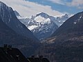
 The east side of the Wildberg from the Saulajoch |
||
| height | 2788 m above sea level A. | |
| location | Vorarlberg , Austria | |
| Mountains | Rätikon , Schesaplana group | |
| Dominance | 1.51 km → Panüelerkopf | |
| Notch height | 153 m ↓ west of the Mannheimer Hütte | |
| Coordinates | 47 ° 4 '5 " N , 9 ° 42' 3" E | |
|
||
| Normal way | West ridge | |

The Wildberg is a 2788 meter high mountain in the Schesaplana group in the Rätikon , a mountain group of the western central Alps in the Austrian state of Vorarlberg . To distinguish it from other wild mountains, it is also called the Brandner Wildberg . Due to its solitary location on the northern edge of the Brandner Glacier, it has a great geographical dominance over its surroundings. Since it can be easily reached from the Mannheimer Hütte , it is a mountain with views that is often climbed. A very pronounced ridge, around two and a half kilometers long, stretches from the summit to the northeast. In the literature, there are no precise details of a first ascent of the Wildberg in the 19th century.
Surroundings
The Wildberg belongs to the Schesaplana group and is located about five kilometers southwest of the Vorarlberg community of Brand . About nine and a half kilometers as the crow flies south-southwest of the mountain is the Graubünden political community of Fanas. South of the Wildberg, the largest glacier in the area, the Brandner Glacier, extends. The northern flank of the mountain falls down into the Zalim Valley with the Zalimalpen . Neighboring mountains are in the south, beyond the Brandner Glacier, the 2965 meter high Schesaplana , the highest mountain in the Rätikon. In the course of the west ridge , separated by a nameless saddle at 2625 meters, lies the Panüelerkopf with a height of 2859 meters and to the northwest, along the curved north ridge, finally the 2176 meter high Mottakopf .
Bases and paths
The mountains of the Schesaplana group are accessible from the north because of the easier climbs. The most important base for an inspection is the Mannheimer Hütte at an altitude of 2679 meters. It is located on the connecting ridge between Panüelerkopf and Wildberg, which is only about half an hour's walk east of the hut and can be easily climbed via the west ridge . Difficult climbing in difficulty level UIAA II and III, on the other hand, requires the north ridge of Wildberg. This is usually done when crossing from the mottled head. The starting point of this demanding alpine tour, first ascent in 1886, is the village of Brand. A walking time of up to seven hours must be expected here. Another base for the Schesaplana group is the Oberzalimhütte ( Obere Zalimalp ) at 1889 meters above sea level, about 1.5 km north of the Wildberg. From here it can be reached via the Leiberweg .
View from Bludenz to the Wildberg (center) after the onset of late winter
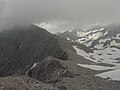
Ridge between Panüeler Kopf and Wildberg (in clouds) with Mannheimer H.


Literature and map
- Manfred Hunziker: Ringelspitz / Arosa / Rätikon . From the Pass dil Segnas to the Schlappiner Joch. Verlag des SAC , Bern 2010, ISBN 978-3-85902-313-0 , p. 541 ( Alpine Tours - Bündner Alpen ).
- Günther Flaig: Rätikon. A guide to valleys, huts and mountains. Written according to the guidelines of the UIAA. 9th revised edition. Bergverlag Rother , Munich 1989, ISBN 3-7633-1098-3 ( Alpine Club Guide . Series: Central Alps ).
- National map of Switzerland 1: 25,000, sheet 1156, Schesaplana
Web links
Individual evidence
- ↑ Vorarlberg Atlas4. Retrieved February 12, 2020 .