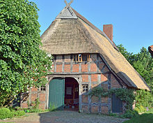
Jardinghausen
|
Jardinghausen
City of Syke
Coordinates: 52 ° 51 ′ 12 ″ N , 8 ° 51 ′ 7 ″ E
|
||
|---|---|---|
| Height : | 35 m | |
| Area : | 7.58 km² | |
| Residents : | 328 (2006) | |
| Population density : | 43 inhabitants / km² | |
| Incorporation : | March 1, 1974 | |
| Postal code : | 28857 | |
| Area code : | 04248 | |
|
Location of Jardinghausen in Lower Saxony |
||
Jardinghausen is the southernmost district of the city of Syke ( Diepholz district , Lower Saxony ).
geography
location
Together with the Syker districts of Henstedt , Heiligenfelde , Wachendorf and Gödestorf , a southern area is formed. The historic districts of Fuldenriede, Wickbranzen and Wisloh belong to Jardinghausen. Jardinghausen is the Syker district with the lowest number of inhabitants, but is third from last in terms of area with 7.58 km².
Jardinghausen belongs together with Henstedt, Heiligenfelde, Wachendorf and Gödestorf to the parish of Heiligenfelde.
Neighboring places
Neighbors of Jardinghausen are the Syker districts of Henstedt, Heiligenfelde and Wachendorf. To the south-east it is the neighboring municipality of Syker, together with the municipality of Bruchhausen-Vilsen, and to the south-west, the district of Neubruchhausen belonging to the city of Bassum .
Rivers / streams
The Hache , which flows in a northerly direction , with its quarry forest , creates a green ribbon through Jardinghausen - an oasis for many plants and animals. The Hache is partly the border river to Neubruchhausen and Henstedt.
history
On March 1, 1974, the community Jardinghausen was incorporated into the city of Syke.
Population development
- 1950: 530 inhabitants
- 1961: 330 inhabitants
- 1966: 303 inhabitants
- 1970: 311 inhabitants
- 1982: 337 inhabitants
- 2006: 328 inhabitants
Infrastructure
Jardinghausen does not have its own church or cemetery . The war memorial in the town center contains the names of 20 fallen and 3 missing from the First World War and the names of 38 fallen and missing from the Second World War . (see war memorials in Syke # Jardinghausen )
traffic
Street
Jardinghausen is far away from major traffic, which actually increases the quality of living. The next federal road, the B 6 , runs 2.5 km to the north through Heiligenfelde and creates good connections to the north (to Bremen , to the A 1 and A 27 ) and to the south (to Hanover , to the A 2 ).
A well-developed main road (the state road L 356) cuts through the core town:
- as "Jardinghauser Straße" it runs north to Heiligenfelde and the B 6
- as "Jardinghauser Straße" and then as "Heiligenfelder Straße" it runs south to Neubruchhausen
In 1974 at the latest, all Jardinghauser streets and some of the paths were given names. In total there are 17 streets and paths in Jardinghausen that have names. There are also some dirt roads that have remained nameless.
Names of the Jardinghauser streets (in alphabetical order): Am Kiefernwald , Auf dem Sünder, Auf den Kempen, Benser Weg, Bomhoff, Dornenkamp, Fuldenriede, Große Heide, Hachkamp, Kastanienallee , Kronsberg, Jardinghauser Straße, Parthuhnsberg , Slagboom, Stegenkamp, Wickbranzer Straße , Wisloher Strasse.
rail
- The nearest railway station is in a westerly direction along the route Bremen - Osnabrück location DB -Bahnhof Bassum. It is about 9 km from Jardinghausen.
- The DB train station in Syke, about 10 km to the northwest, belongs to the same route.
societies
In Jardinghausen there is a volunteer fire brigade and a youth fire brigade.
See also
literature
- Jardinghausen. In: Heinz-Hermann Böttcher, Heiner Büntemeyer, Hermann Greve and Wilfried Meyer: SYKE and umzu. Syke 1983, ISBN 3-923965-00-1 , pp. 186-191
- Jardinghausen. In: Hermann Greve u. Gabriele Ullrich : 13 times Syke. A historical reading tour. Weyhe 1992, pp. 140-153
- Marsh marigolds route (including Jardinghausen). In: Hermann Greve u. Gabriele Ullrich: On the way ... in Syke. A culture and nature travel guide for Syke and its districts. A guide through the Hachestadt. Nature - culture - history. Fischerhude 2002, pp. 102-123
- Jardinghausen. In: Hermann Greve u. Klaus Fischer : Cityscapes from Syke. Leipzig 1996, pp. 10 and 41
Individual evidence
- ↑ a b c Federal Statistical Office (ed.): Historical municipality directory for the Federal Republic of Germany. Name, border and key number changes in municipalities, counties and administrative districts from May 27, 1970 to December 31, 1982 . W. Kohlhammer GmbH, Stuttgart and Mainz 1983, ISBN 3-17-003263-1 , p. 191 .


