Salaruelkopf
| Salaruelkopf | ||
|---|---|---|
|
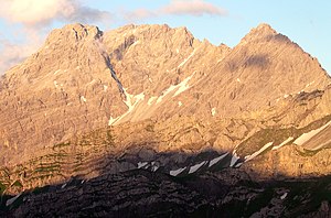
The Salaruelkopf (center) from the west. Left the Panüelerkopf, right the Schafberg. |
||
| height |
2841 m above sea level A. 2841 m above sea level M. |
|
| location | Vorarlberg , Austria / Graubünden , Switzerland | |
| Mountains | Rätikon | |
| Coordinates , ( CH ) | 47 ° 3 '41 " N , 9 ° 40' 39" O ( 770063 / 214689 ) | |
|
|
||
| First ascent | 1849 | |
| Normal way | from the Mannheimer Hütte to the east over the Panüelerkopf then over the north ridge | |
The Salaruelkopf is with a height of 2,841 meters is the third highest mountain in the Rätikon , a mountain range in the Western Central Alps . The survey point of the summit is exactly on the state border between the Austrian state of Vorarlberg and the Swiss canton of Graubünden . The mountain is a rather insignificant elevation in the course of the Panüelerkopf south ridge compared to the Panüelerkopf neighboring and 18 meters higher .
A first ascent was probably made in connection with that of the Panüelerkopf, according to literature in 1849 by an Anton Neyer from Bludenz . The Salaruelkopf sends out partly pronounced ridges to the southwest and northeast, but hardly accessible due to the fragile rock. However , the mountain is easy to climb via the north ridge .
Surroundings
The Salaruelkopf belongs to the Schesaplana group and is located in the Alpstein , a mountain range that is a good seven kilometers long from the northwest ( Salarueljoch , 2,243 m) to the southeast ( Lünersee , water level at 1,970 m), to which the Schafberg (2,727 m), the Schesaplana (2,964 m) ), as well as the pulpit heads (maximum height 2,442 m) belong. To the east of the Salaruelkopf, on Austrian territory, lies the Brandner Glacier , which rises on the eastern flank of the mountain to a height of 2,880 meters. Neighboring peaks are the Schafberg in the west, the 2,859 meter high Panüelerkopf in the north, the Schafköpfe (2,806 m) and the Schesaplana in the east .
The nearest settlement in the south is Fanas in Graubünden, about 6 kilometers as the crow flies , and in the northwest, 3 kilometers away, the place Nenzinger Himmel in the upper Gamperdontal , Vorarlberg.
Bases and paths
As a rule, the mountains of the Schesaplana group are climbed from the north because of the easier climbs. The Salaruelkopf is best approached from the north when crossing the higher Panüelerkopf. As a base used for this Normalweg the Mannheimer hut at 2,679 meters above sea level. The path leads in a westerly direction over a gently sloping firn field of the Brandner Glacier and over Schrofen to the ridge connecting the two mountains. According to the literature, the walking time is about an hour from the hut. From the Oberzalimhütte at 1,889 meters, the artificial, very exposed Straussweg leads in about 5 hours from the north to the summit.
Literature and map
- Manfred Hunziker: Ringelspitz / Arosa / Rätikon , Alpine Touren / Bündner Alpen , Verlag des SAC 2010, ISBN 978-3-85902-313-0 , p. 538
- Günther Flaig: Alpine Club Guide Rätikon , Bergverlag Rudolf Rother , Munich 1989, ISBN 3-7633-1098-3
- Eduard Richter (editor): The development of the Eastern Alps, Volume I , publishing house of the German and Austrian Alpine Association, Berlin 1893
- National map of Switzerland 1: 25,000, sheet 1156, Schesaplana

