
Survey point


A survey point , or measurement point for short, is a point marked in a stable manner in the ground or on a building, which geodesists use as the starting or destination point for measurements .
However, the term is not defined uniformly. Sometimes it is understood more narrowly in the sense of a fixed point : "A point that is determined in terms of location and / or height and is usually permanently fixed, to which topographical recordings, engineering or property measurements are connected."
Measurement points are determined as trigonometric points (TP) by means of triangulation . Height control points are determined by geometric leveling .
Measurement point in the sense of fixed point
Measurement points are differentiated according to fixed points of the position, height and gravity fixed point field. For fixed position points (LFP), coordinates are calculated in a position reference system and they are mostly suitable as a set-up point for a surveying tripod with theodolite . Height control points (HFP) are used to determine heights above sea level, while for gravity control points (SFP) information on the force of gravity is measured and calculated.

With the increasing importance of GPS surveying , these previously separate fixed point fields are increasingly becoming three-dimensional fixed points thanks to suitable markings. A line of sight over long distances is no longer necessary today.
Overview of the surveying points that have been created in Germany since around 1820

- Geodetic fixed points of the national survey - with stable above and below ground markings and typical positional accuracies of 1–5 cm
- in particular points of a triangulation ( definition , a plate and TP pillar), measuring pillar with signpost,
- Geodetic height control points of the national survey - with stable above-ground markings or as underground definition (UF) and typical height accuracies of ± 0.1 to 1 mm
- in particular, marketed leveling points (such as wall bolts (MB) or height markers ( HM) on churches (mostly on the church tower), train stations (mostly on the track side))
- Fixed points of another surveying network - with stable marking and accuracies between 0.1 mm and about 10 cm (depending on the network size and purpose),
- For example technical control networks, measurement consoles, ridge points in the mine or tunnel
- Points that have been measured with GPS over a long period of time or measurement consoles.
Other stable marketed survey points
In the parlance of most geodesists, surveying points also count
- Well-defined, controlled "detail points" that are clearly defined and stabilized on buildings or at borders - for example house corners, wall and border points
- Well-defined, immovable points in nature - for example, marks on rock or on large blocks in geodynamics measurements on mountain slopes or glaciers
- Ground marks in solid road pavement or on sidewalks - mostly bolts or nails with the inscription "measurement point" or "measuring point"
- Screw marks or stably driven pegs , if possible with a notice peg or protective scaffolding
- Geodetic reference points for checking GPS receivers
- other permanently marketed items

Height control point ( height mark ) at the Alexander Church in Wallenhorst

Height control point (Markstein) in a forest in Berlin-Spandau

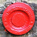
Surveying point, this version is also called "Ulmer cover".
Triangulation point Gisliflue, Jura / Switzerland, 772 m. ü. M.

Historic high point (Bad Saulgau - St. Johannes Church)
Elevation mark "Königlich Prussische Landesaufnahme" at the church in Siebleben

Elevation mark "Königlich Prussische Landesaufnahme" in Stradaunen , Masuria

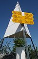
Survey tower sketch
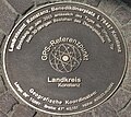
GPS reference point table in Constance

GPS reference in Oldenburg

GPS reference point in Frankfurt am Main

GPS reference point Kurfürstenstein, Rennsteig, Thuringia


Points and measures in databases
In the age of IT , the measurement points are stored in databases for almost all work . In addition to names and coordinates , the "history of origin" and the relationship between the points are noted, so that the exact position of each measurement point can be updated at any time using new measurement data . Such measurements are mainly:
- Cuts with rays ( directions ) and stretches ( distances ), so mostly forward cut and arc cut
- Polar points (direction + distance)
- Blocking dimensions (control distances ) between individual points, definition of circular arcs, etc., as well as
- Polygonization (polygon course) and free stationing for the installation points of the theodolite
In geographic information systems , individual elements are often linked to survey points, for example in order to transform local coordinates into a higher-level reference system . The information about which points such links exist is usually stored in the geometry of the GIS element.
See also
- Lookout point
- eccentric
- geodesy
- High stand
- Steeple
- First order network
- Control point
- Plumb bob
- Struve arch
- Triangulation (geodesy)
- Land surveying office
- Centering
literature
- H. Kahmen: Surveyors. 19th edition. De Gruyter textbook, Berlin 1997, 732 pages.
- W. Torge: Geodesy. 2nd Edition. De Gruyter textbook, Berlin 2003, 370 pages.
Web links
swell
- ↑ Archived copy ( memento of the original dated September 2, 2006 in the Internet Archive ) Info: The archive link was inserted automatically and has not yet been checked. Please check the original and archive link according to the instructions and then remove this notice.