Struve arch
| Struve arch | |
|---|---|
|
UNESCO world heritage |
|

|
|
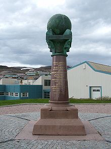
| Meridian monument in Hammerfest, built according to a design by Wilhelm von Hanno (1856) |
|
| National territory: |
|
| Type: | Culture |
| Criteria : | ii, iii, vi |
| Reference No .: | 1187 |
| UNESCO region : | Europe and North America |
| History of enrollment | |
| Enrollment: | 2005 (session 29) |
The Scandinavian-Russian meridian arc or Struve arc for short , named after the Baltic German astronomer Wilhelm von Struve (1793–1864), is a degree measurement that consists of a nearly 3000 km long network of geodetic survey points . The Struve-Bogen is one of the most precise and largest projects of the earth's surveying at the time , has been a UNESCO World Heritage Site since 2005 and is managed internationally under the leadership of the Fédération Internationale des Géomètres (International Association of Surveying Engineers, FIG).
Shape and size
The Struve Arc extends from Fuglenes ( 70 ° 40 ′ 11 ″ N , 23 ° 38 ′ 48 ″ E , near Hammerfest in Northern Norway ) to Stara Nekrassiwka ( 45 ° 20 ′ 48 ″ N , 28 ° 55 ′ 48 ″ E , near Ismajil on the Black Sea ) and runs - comparable to a meridian arc - through Norway, Sweden , Finland , Russia , Estonia , Latvia , Lithuania , Belarus , Ukraine and the Republic of Moldova . In north-south direction, it extends over a total of 2821.833 km (= 25 ° 20'08 ″). The Struve arch consists of a total of 265 survey points that form 258 main triangles. There are also over 60 secondary survey points.


There are only two measuring points in buildings:
- The Tartu observatory ( Tartu , Estonia / built by J. W. Krause at the beginning of the 19th century) serves as the origin of the triangulation. It was restored from 2009 to 2011 and is now part of the Museum of the University of Tartu .
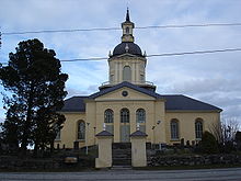
- The church of Alatornio (Finland) (1797) has remained practically in its original state. A point within the church tower serves as the measuring point . (The church of Tornio was used as early as 1736–1737 by Pierre-Louis Moreau de Maupertuis for his measurements to flatten the earth's ellipsoid .)
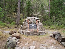
The other points are obelisks, cairns and the like.
Emergence
His double chain of points, stiffened by triangulation , was erected from 1816 to 1852 under the supervision of Struve and the Russian officer Carl Tenner (1783-1859) in order to precisely determine the figure of the earth (size, shape, flattening) in Northern and Eastern Europe. Both geodesics cooperated in the southern section. Further north (to the south point of Maupertuis ' degree measurement ) Friedrich Woldstedt , director of the Helsinki observatory , oversaw the surveying work, which - most recently under Swedish management and difficult conditions - extended to Fuglenes.
UNESCO World Heritage Site
In addition to its importance for geodesy, the Struve Arch is also an early example of international scientific cooperation. Represented by 34 of its measuring points, it was therefore included in the list of the world cultural and natural heritage of mankind by the World Heritage Committee of UNESCO on July 15, 2005, making it the first scientific instrument on this list.
The following measuring points, which are part of the world cultural heritage, have been selected according to their importance. They are evenly distributed over the entire arch, represent all participating countries, correspond to the points originally used, are only marginally endangered and can be maintained by local institutions.
- Norway:
- Fuglenes ( 70 ° 40 ′ 12 ″ N , 23 ° 39 ′ 48 ″ E , Hammerfest)
- Lille-Raipas ( 69 ° 56 '19 " N , 23 ° 21' 37" O , Unna Ráipásaš; Alta )
- Lodiken ( 69 ° 39 '52 " N , 23 ° 36' 8" O , Luvdiidcohkka; Kautokeino )
- Bealjášvárri ( 69 ° 1 '43 " N , 23 ° 18' 19" O , Bealjášvárri; Kautokeino)
- Sweden:
- Tynnyrilaki ( 68 ° 15 '18 " N , 22 ° 58' 59" O , Kiruna )
- Jupukka ( 67 ° 16 '36 " N , 23 ° 14' 35" O , Pajala )
- Pullinki ( 66 ° 38 '47 " N , 23 ° 46' 55" O , Övertorneå )
- Perävaara ( 66 ° 1 '5 " N , 23 ° 55' 21" O , Haparanda )
- Finland:
- Stuor-Oivi ( 68 ° 40 '57 " N , 22 ° 44' 45" O , Enontekiö )
- Aavasaksa ( 66 ° 23 ′ 52 ″ N , 23 ° 43 ′ 31 ″ E , Ylitornio )
- Alatornio Church ( 65 ° 49 ′ 48 ″ N , 24 ° 9 ′ 26 ″ E , Tornio )
- Oravivuori ( 61 ° 55 '36 " N , 25 ° 32' 1" O , Korpilahti )
- Tornikallio ( 60 ° 42 '17 " N , 26 ° 0' 12" O , Lapinjärvi )
- Mustaviiri ( 60 ° 16 '35 " N , 26 ° 36' 12" O , Pyhtää )
- Russia:
- Mäki-päälys ( 60 ° 4 '27 " N , 26 ° 58' 11" O , Gogland , Rayon Kingissepp )
- Gogland , Z ( 60 ° 5 ′ 7 ″ N , 26 ° 57 ′ 40 ″ E , Kingissepp Rajon)
- Estonia:
- Woibifer ( 59 ° 3 '28 " N , 26 ° 20' 16" O , Avanduse )
- Katko ( 59 ° 2 ′ 54 ″ N , 26 ° 24 ′ 51 ″ E , Avanduse)
- Tartu Observatory ( 58 ° 22 ′ 44 ″ N , 26 ° 43 ′ 12 ″ E , Tartu )
- Latvia:
- Sestu-Kalns ( 56 ° 50 '24 " N , 25 ° 38' 12" O , Sausnēja )
- Jacobstadt ( 56 ° 30 ′ 5 ″ N , 25 ° 51 ′ 24 ″ E , Jēkabpils )
- Lithuania:
- Karischki ( 55 ° 54 '9 " N , 25 ° 26' 12" O , Panemunėlis )
- Meschkanzi ( 54 ° 55 ′ 51 ″ N , 25 ° 19 ′ 0 ″ E , Nemenčinė )
- Beresnäki ( 54 ° 38 '4 " N , 25 ° 25' 45" O , Nemezis )
- Belarus:
- Tupischki ( 54 ° 17 '30 " N , 26 ° 2' 43" O , Ashmyany )
- Lopati ( 53 ° 33 '38 " N , 24 ° 52' 11" O , Selwa )
- Ossownitza ( 52 ° 17 '22 " N , 25 ° 38' 58" O , Iwanowo )
- Tchekuzk ( 52 ° 12 '28 " N , 25 ° 33' 23" O , Iwanowo)
- Leskovichi ( 52 ° 9 ′ 39 ″ N , 25 ° 34 ′ 17 ″ E , Ivanovo)
- Ukraine:
- Katerinowka ( 49 ° 33 ′ 57 ″ N , 26 ° 45 ′ 22 ″ E , Kateryniwka )
- Felschtin ( 49 ° 19 '48 " N , 26 ° 40' 55" O , Hwardijske )
- Baranowka ( 49 ° 8 ′ 55 ″ N , 26 ° 59 ′ 30 ″ E , Baranivka )
- Staro-Nekrasowka ( 45 ° 19 ′ 54 ″ N , 28 ° 55 ′ 41 ″ E , Stara Nekrasiwka )
- Moldova:
- Rudi ( 48 ° 19 ′ 8 ″ N , 27 ° 52 ′ 36 ″ E , Rudi , Soroca Rajon )
Others
- Wilhelm von Hanno designed the meridian monument for the Struwe Arch in 1854 , and it was completed in 1856.
- The first (rounded) "square" commemorative coin of Belarus (December 29, 2006, 1 ruble , Ag925 , largest diameter = 36 mm, m = 33.63 g , mintage 5000 pieces) shows the complete course and on one side on the other side the Belarusian part of the Struve Arch.
- An Estonian postage stamp (1932) shows the observatory in Tartu.
- On May 12, 2011, the Swedish Post issued a stamp pad with two triangular stamps on the theme of Struve sheets.
Web links
- Comprehensive special wiki Struve-Bogen (English)
- Entry on the UNESCO World Heritage Center website ( English and French ).
- Flyer (PDF, English; 859 kB)
- Information at the International Federation of Surveyors (English)
- The Struve Geodetic Arc by JR Smith (English; PDF file; 1.27 MB)
swell
- ↑ Image of the observatory ( page no longer available , search in web archives ) Info: The link was automatically marked as defective. Please check the link according to the instructions and then remove this notice.
- ↑ Archived copy ( memento of the original dated August 24, 2011 in the Internet Archive ) Info: The archive link was inserted automatically and has not yet been checked. Please check the original and archive link according to the instructions and then remove this notice.
- ↑ a b N.N .: “On the 150th anniversary of the death of Friedrich Georg Wilhelm von Struve”. In: zfv - Journal for Geodesy, Geoinformation and Land Management , Volume 139, No. 6/2014, ISSN 1618-8950 , p. N-94.
- ↑ Coordinates according to information from UNESCO
- ↑ Description of the Finnish measuring points ( memento of the original dated November 27, 2014 in the Internet Archive ) Info: The archive link was inserted automatically and has not yet been checked. Please check the original and archive link according to the instructions and then remove this notice.
- ↑ image of the coin
- ↑ Information on the Swedish special stamp


