
Geirangerfjord
| Geirangerfjord | ||
|---|---|---|
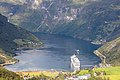
 Overview of the east end of the Geirangerfjord, July 2010 |
||
| Waters | Sunnylvsfjord | |
| Land mass | Scandinavian peninsula | |
| Geographical location | 62 ° 6 ' N , 7 ° 5' E | |
|
||
| length | approx. 15 km | |
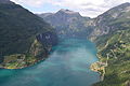
 Panorama from Adlerstrasse in June 2013 |
||


The Geirangerfjord is one of the most famous fjords in Norway and has been a UNESCO World Heritage Site since July 14, 2005 . It is located about 200 km (as the crow flies) northeast of Bergen and about 280 km (as the crow flies) northwest of Oslo in the province of Møre og Romsdal .
It is about 15 km long and between 0.6 and 1.3 km wide. The Geiranger is a continuation of the Sunnylvsfjord , which in turn is a branch of the Storfjord . At the end of the Geirangerfjord, about 100 km from the coast flies, the place is Geiranger .
In professional circles, the Nærøy and Geirangerfjords are considered to be a “natural history laboratory”, as they constantly provide new insights into landscape formation and the effects of climate change.
Geography, landscape and geology
Around 2.5 million years ago, rivers carved out deep valleys along geological weak points. The fjords of this area were formed when the glaciers of the Quaternary glacial these valleys to large trough valleys , formed with exceptionally high and steep cliffs in which accumulated after the end of the Ice Age seawater.
The Geirangerfjord emerges from the Storfjord alongside the Tafjord and the Sunnylvsfjord along the watershed . The fjords are very steep, sometimes almost vertically, into high mountain-like areas. On the alpine mountain ranges between the fjords there are some fertile high alpine pastures with great cultural and historical value. Several avalanche fields , often located between deciduous forests, have unique ecosystems with rare animal species.
Flora and fauna
The biodiversity of the plant world results from the many different habitats and the exceptionally mild climate. The formerly cultivated pieces of land offer another special habitat for some plants.
Not least because of the variety of plants, numerous mammals live in and around the Geirangerfjord such as mountain reindeer , elk , deer , roe deer , arctic foxes , lynxes , otters , lemmings (or wood lemmings ) and porpoises , but also fish , insects and over 100 species of birds , including the white-backed woodpecker and many other sea , wading , forest and high mountain birds . Quite a few animals are on the red list of endangered species .
Cultural history
When the glaciers in this area melted around 10,000 years ago, the first settlers arrived. The great importance of reindeer hunting at this time could be demonstrated by means of animal trapping pits and hunting hiding places .
Fjord courtyards
On the steep slopes of the fjord you can still see some, now abandoned, farms, some at dizzying heights, which were mostly built in places safe from snow and stone avalanches . Some of the farms and alpine huts, which have now been partially restored, were previously only accessible via ladders. Nevertheless, agriculture was worthwhile in this area at that time, as the mild climate with (in summer) almost 24 hours of sunshine at the fjord even allowed southern fruits such as apricots to be harvested. Today the courtyards are among the most important cultural and historical sites in the region. The organization "Friends of the Storfjord" is very committed to ensuring that these farms have been restored and preserved.
Skageflå
The Skageflå farm is located on the south side of the Geirangerfjord at approx. 250 m above sea level. NN . It was given up in 1917 , but until 1970 it was farmed as meadow land. Hay was dried in the meadows, which was lowered to the fjord with wire rope winches and from there brought by boat to Homlong on the Geirangerfjord. The official UNESCO plaque , which documents the status of the Geirangerfjord as a World Heritage Site , was unveiled and signed by Queen Sonja on July 12, 2006 at Skageflå Farm. Today the farm can be reached on foot from the fjord on a steep path.
Blomberg
The Blomberg farm is located on the south side of the Geirangerfjord at approx. 452 m above sea level. NN . He was left in 1947. It was restored within five years for around NOK 2.6 million and is now in good condition. The farm can be reached from the fjord via a path that climbs up the steep slope in 28 curves.
Knivsflå
The Knivsflå farm is located on the north side of the Geirangerfjord at approx. 250 m above sea level. NN at the waterfall " The Seven Sisters ". It was abandoned in 1898 because there is a dangerous rock overhang nearby that was then believed to be about to slide. Until the 1960s, the farm was used as meadow land, the hay was dried and lowered to the fjord with wire rope winches. There it was loaded onto row boats and taken to Geiranger .
tourism
v.Adlerstr.jpg)
A special tourist attraction is the trip with the ferry Hellesylt- Geiranger or one of the ships of the Hurtigruten , which sail the fjord in summer - this is not possible in winter due to the avalanches that can cause high waves. The waterfalls " The Seven Sisters " ( Norwegian: De syv søstre ) or the waterfalls Freier , Bridal Veil , Ljosurfossen , Bringefossen , Gjerdefossen or Grinddalsfossen are worth seeing . Another attraction is the ride on the " Eagle Road " (norw .: Ørneveien ) with its eleven hairpin bends and the beautiful views of the Geiranger Fjord. In addition to ferry rides, hiking, fishing and kayaking are popular activities for travelers.
UNESCO World Natural Heritage
Together with the Nærøyfjord , the Geirangerfjord was declared a UNESCO World Heritage Site "Western Norwegian Fjords" (Norwegian: "Vestnorsk fjordlandskap"). This is due to the fulfillment of two nature conservation criteria, as the area has a unique natural diversity, which was created by the symbiosis of sea and high mountains, and a landscape that is largely unaffected by human interference.
The 1227 km² area (of which 107 km² water area) includes the inner areas of the fjords, which extend to the central mountain range, which geographically separates eastern Norway from western Norway. The area around the Geirangerfjord has a size of 518 km², that of the Nærøyfjord an area of 709 km².
The UNESCO Committee justified the decision to include the fjords as follows:
“The Western Norwegian fjords represent classic and, above all, particularly well-developed types of fjords, which can be seen as typical examples for all fjords in the world. Their power and majesty are comparable to other fjords that have already been included in the World Heritage List. Furthermore, they are characterized by their special climatic and geological conditions. The area exhibits all of the elements of the processes that form two of the longest and deepest fjords in the world.
Nærøy- and Geirangerfjord are considered to be by far the most beautiful fjord landscapes in the world. Their sublime nature is expressed by the narrow, steeply sloping valley walls, which extend from 500 m below sea level to 1,400 m above sea level. Numerous waterfalls plunge down the extremely steep rock faces, and countless torrents flow from snow-capped peaks, glaciers and glacial lakes through deciduous and coniferous forests down into the fjord. The variety of other natural phenomena on land and water, such as submarine moraines and marine mammals, enhance the experience of nature. Remains of old, now abandoned farms and alpine huts give the dramatic natural landscape a cultural dimension that supports and reinforces the value of this area. "
Picture gallery

Waterfalls The Seven Sisters in the Geirangerfjord, around 1900

Waterfalls The Seven Sisters in the Geirangerfjord in May 2008
View of Geiranger and the Geirangerfjord
View from Løsta over the Geirangerfjord

Panorama from the water


Web links
- Geiranger website of the tourist information
- Destinasjon Geirangerfjord - Trollstigen
- Webcam
- Stern article
- Western Norwegian Fjords - Information brochure of the Norwegian Directorate for Nature Management on the UNESCO World Heritage Site (German)
- Tourist Office Norway

Heritage: Urnes Stave Church (1979) | Bryggen - port city of Bergen (1979) | Town and mines of Røros (1980) | Alta Rock Art (1985) | Vega Archipelago (2004) | Struve Arch (2005) | Industrial sites in Rjukan and Notodden (2015)
Natural heritage: Western Norwegian fjords - Geirangerfjord and Nærøyfjord (2005)