Storfjord (Sunnmøre)
| Storfjord | |
|---|---|
|
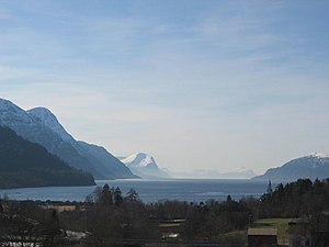
View to the west over the outer parts of the Storfjord |
|
| Waters | European Arctic Ocean |
| Land mass | Scandinavian peninsula |
| Geographical location | 62 ° 27 ' N , 6 ° 36' E |
| length | 86 km |
| Greatest water depth | 679 m |
| Islands | Sula |
|
Storfjord near Stranda |
|
The Storfjord in Sunnmøre is a 86 km long fjord in Møre og Romsdal in Norway .
It runs through seven municipalities, namely from the coast: Hareid , Sula , Ørsta , Sykkylven , Ålesund , Fjord and Stranda .
A lower branch of one of its branches is also called "Storfjord".
geography
entrance
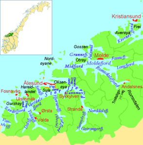
The fjord flows between the Kvitneset peninsulas in Hareidlandet and Eltraneset on the island of Sula . The outer part, actually a sound between the two islands of Sula and Hareidland, is also called the Sulafjord . South of Hareidland, the Vartdalsfjord flows from the southwest , which connects this island with the Voldafjord and separates it from the mainland.
Bulk
South of the island of Sula, the Storfjord turns inland, to Sjöholt in an easterly direction, then in a southerly direction. The north bank of the first section is formed by the island of Oksenøya , in addition to Sula . In front of and behind it, the fjord has close links to the Heissafjord and Ellingsøyfjjord, between which most of Ålesund's urban area lies.
Inner branches
The actual Storfjord ends at Stranda and divides into the Norddalsfjord, which leads east, and the Sunnylvsfjord, which leads south . The latter extends south to Hellesylt . Three kilometers from the end, the Geirangerfjord branches off to the east as a longer arm . At the end of this is the place Geiranger . The borders of the three provinces Møre og Romsdal, Innlandet and Vestland meet 10 km southeast of it .
The greatest depth of the fjord is 679 m between Skotet and Dyrkorn in the municipality of Stordal.
Hjørundfjord and small Storfjord
The largest branch of the Storfjord is the Hjørundfjord. It extends in a south-southeast direction and branches after 22 km into the smaller branch Norangstfjord and the larger branch Storfjord, which is identified by the municipality name Ørsta to distinguish it from the main fjord of the same name , although the eponymous core town of this municipality on a western branch of the Vartdalsfjord ( see above) ) lies.
links

In the outermost part of the fjord runs the national road 61, which crosses the Sulafjord with the ferry connection Hareid - Sulesund and then continues eastwards on the south side of the fjord until it meets the E 39 . This comes from the south and crosses the fjord with a ferry between Festøya in Ørsta and Solevåg in Sula. At Blindheim, national road 60 branches off the E39 to the east along the south side of the Ålesund peninsula and crosses the fjord by ferry between Magerholm in the north and Aursnes in Sykkylven on the south side of the fjord. From Magerholm the national road 656 continues on the north side of the fjord to Valle in the municipality of Skodje. Here the E39 meets the fjord again and follows it east to Sjøholt in the municipality of Ørskog.
From Sjøholt the national road 650 leads south along the east side of the fjord until it meets the national road 63 at Linge, which crosses the Norddalsfjord to Eidsdal by ferry . There is also a ferry from National Road 650 to Stranda on the west side of the fjord, which is largely free of roads between Sykkylven and Stranda. Along the inner part of the fjord, the Sunnylvsfjorden and the Geirangerfjord , there are no roads except in Hellesylt , where the national road 60 follows again for a few kilometers to the fjord and Geiranger , where the National Road 63 as Ørneveien ( German Eagle Road ) from Eidsdal comes over a pass and then drops to the fjord and follows it to Geiranger. From there it continues to Oppland.
There are several ferry connections across the branching Hjørundfjord , including for the national route 655 between Sæbø and Lekneset .
Overview of the side fjords
The Storfjord is very branched. The most important side fjords are counted inland from the coast:
-
Hjørundfjord (33 km)
- Norangsfjord (6.5 km)
- Storfjord i Ørsta (11 km)
- Sykkylvsfjord (9 km)
-
Norddalsfjord (16 km, including Tafjord)
- Tafjorden (8 km)
-
Sunnylvsfjord (26 km)
- Geirangerfjord (15 km)
See also
- Storfjord for other occurrences of the name.


