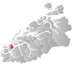
Hareid
| coat of arms | map | |
|---|---|---|

|
|
|
| Basic data | ||
| Commune number : | 1517 | |
| Province (county) : | Møre and Romsdal | |
| Administrative headquarters: | Hareid | |
| Coordinates : | 62 ° 22 ′ N , 6 ° 2 ′ E | |
| Surface: | 82.27 km² | |
| Residents: | 5,175 (Feb 27, 2020) | |
| Population density : | 63 inhabitants per km² | |
| Language form : | Nynorsk | |
| Website: | ||
| politics | ||
| Mayor : | Bernt Brandal (Folkelista for Hareid commune) (2011) | |
| Location in the province of Møre og Romsdal | ||

|
||
Hareid is a place and a municipality in the Norwegian Fylke Møre og Romsdal . The municipality has 5175 inhabitants (as of February 27, 2020), the place Hareid serves as an administrative center and has 3434 inhabitants (as of 2019).
Geography and traffic
Hareid is, together with the municipality of Ulstein, on the island of Hareidlandet , west of Ålesund and extends from north to south over the associated Breidsundet and the Vartdalsfjorden by 19.2 kilometers and from east to west by 14.1 kilometers. The highest elevation is with a height of 683 moh. the songful .
From the main town of Hareid, ferries run to Ålesund and to Valderøy , the administrative center of Giske municipality . Other larger places in the municipality are Bigset, Brandal , Hareid and Hjørungavåg.
The neighboring communes of Hareid are Giske, Sula , Ørsta and Ulstein.
The residents of Hareid are called Hareiding . As in most municipalities in the province of Nynorsk , the official language form is the rarer of the two Norwegian written languages.
history
It is generally believed that the battle at Hjørungavåg between Jarl Håkon and the Jómswikings who sailed from Denmark took place here in 986 or 994 .
The municipality of Hareid has been independent since 1916, before it belonged to the neighboring municipality of Ulstein .
economy
Agriculture does not play a major role in the municipality. Most farmers are part-time and the farmers focus on cattle and sheep farming . Fishing is more important for the municipality , although few fishing boats are registered in Hareid itself.
Furthermore, industrial production is important for the economy. The main activity is in mechanical engineering. The largest farms are in Hareid and Hjørungavåg.
In 2019, the employer of only 1,097 of Hareid's 2,481 employees was within the municipality. Many employees were employed in Ulstein (706 people), Ålesund (180 people) or Herøy (110 people).
Personalities
- Einar Hareide (1899–1983), politician
- Åge Hareide (* 1953), football player and coach
Web links
- Municipality of Hareid in the store norske leksikon (Norwegian)
- Location Hareid in the store norske leksikon (Norwegian)
- Facts about Hareid at Statistisk sentralbyrå (Norwegian)
Individual evidence
- ↑ Statistisk sentralbyrå - Befolkning
- ↑ Tettsteders following og areal. In: ssb.no. Statistisk sentralbyrå , December 20, 2019, accessed May 31, 2020 (Norwegian).
- ↑ Høyeste fjelltopp i hver commune. In: kartverket.no. States Kartverket, September 1, 2015, accessed May 31, 2020 (Bokmål in Norwegian).
- ↑ Innbyggjarnamn. Språkrådet, accessed May 31, 2020 (Norwegian).
- ↑ Forskrift om målvedtak i Kommunar og fylkeskommunar (målvedtaksforskrifta). In: Lovdata. January 6, 2020, accessed May 31, 2020 (Norwegian).
- ↑ Hans Jacob Orning: Slaget ved Hjørungavåg - Norge history. In: norgeshistorie.no. University of Oslo , November 25, 2015, accessed May 31, 2020 (Norwegian).
- ^ A b John Stokkan, Geir Thorsnæs: Hareid . In: Store norske leksikon . March 5, 2018 (Norwegian, snl.no [accessed May 31, 2020]).
- ↑ Pendlingsstrømmer. Statistics Norway, accessed May 31, 2020 (Norwegian).

