Herøy (Møre og Romsdal)
| coat of arms | map | |
|---|---|---|

|
|
|
| Basic data | ||
| Commune number : | 1515 | |
| Province (county) : | Møre and Romsdal | |
| Administrative headquarters: | Fosnavåg | |
| Coordinates : | 62 ° 21 ' N , 5 ° 38' E | |
| Surface: | 119.52 km² | |
| Residents: | 8,900 (Feb. 27, 2020) | |
| Population density : | 74 inhabitants per km² | |
| Language form : | Nynorsk | |
| Website: | ||
| politics | ||
| Mayor : | Bjørn-Halvor Prytz ( Ap ) (2019) | |
| Location in the province of Møre og Romsdal | ||

|
||
Herøy is a Norwegian municipality in Fylke Møre og Romsdal .
The municipality comprises the Sørøyane archipelago southwest of Ålesund . In addition to the inhabited islands of Herøya , Leinøya , Bergsøya , Remøya , Runde and Nerlandsøya , part of the island of Gurskøya also belongs to the municipality. There are also 359 islets and skerries and the uninhabited islands of Skorpa and Svinøya with the Svinøy fyr beacon . The municipality has 233 km of coastline; the highest point is on Gurskøya with the 660 m high mountain Sollia .
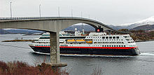
All islands are interconnected with bridges . The municipal administration is located in the fishing town of Fosnavåg .
The motto of the municipality is: “Herøy - ei båtlengt føre” (Herøy - one boat length ahead).
In Norway there is a second municipality with the same name: Herøy in Fylke Nordland .
Culture
Every year on the first weekend in July, the Viking musical Kongens Ring is performed on the island of Herøya .
economy
In addition to fishing and agriculture, the community's livelihood is a considerable fleet of supply ships for the oil industry off the west coast of Norway . The Herøy fleet comprises around 114 supply, offshore and coast guard vessels as well as 27 fishing vessels.
Shipping companies based in Herøy
- Bourbon Offshore Norway AS
- Fosnavaag Shipping AS
- Havila Shipping ASA
- Olympic Shipping AS
- Rem Offshore ASA
- Rem Star AS
- Remøy Management AS
- Remøy Shipping AS
tourism
The bird island Runde is of particular importance for tourists , ornithologists and botanists . With around 170,000 breeding pairs per year, Runde is Scandinavia's southernmost and third largest bird cliff. The island is easily accessible by a bridge connection ( Rundebrua ) to the mainland. Since the opening of the Eiksund tunnel , the community can also be reached without a domestic ferry.
In 2009 an international research institute, the Runde Miljøsenter , was opened on the island of Runde . Since 2011, part of the “Round Treasure” has been on display in Miljøsenter.
The municipality owns a Hurtigruten port, Herøyterminalen in Torvik .
Well-known people in the community
- Lars Ivar Moldskred - Molde FK football player
- Svein Møller (1958–1999) - cantor and composer
- Gerald Pettersen - actor
- Bjarne Rabben - writer, local politician
- Trude Teige - journalist for TV 2
- Ragnar Thorseth - adventurer, circumnavigator with the Viking ship Saga Siglar
- Suzannah Ibsen - wife of the writer Henrik Ibsen
- May-Britt Moser - 2014 Nobel Prize Winner in Medicine
Web links
- Official website of Herøy Municipality
- Sunnmørskart - online maps and aerial photos of the region
- Statistics about Herøy
- List of ships in the Herøy fleet
Individual evidence


