Ørsta
| coat of arms | map | |
|---|---|---|

|
|
|
| Basic data | ||
| Commune number : | 1520 | |
| Province (county) : | Møre and Romsdal | |
| Administrative headquarters: | Ørsta | |
| Coordinates : | 62 ° 12 ' N , 6 ° 8' E | |
| Surface: | 661.58 km² | |
| Residents: | 10,825 (Feb 27, 2020) | |
| Population density : | 16 inhabitants per km² | |
| Language form : | Nynorsk | |
| Postal code : | 6150 | |
| Website: | ||
| politics | ||
| Mayor : | Stein Aam ( Sp ) (2015) | |
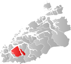
| Location in the province of Møre og Romsdal | ||

|
||
Ørsta is a place and a municipality in the Norwegian Fylke Møre og Romsdal . The administrative center of the municipality is Ørsta. The place was originally known as Ørsten until 1917 .
geography
The municipality extends from north to south 38.3 kilometers and from east to west 43.2 kilometers. The highest peak is the Kvitegga at 1717 meters. Lake Lyngnstøylvatnet lies in the area of Ørsta municipality .
Neighboring municipalities are Hareid , Stranda , Sula , Sykkylven , Ulstein and Volda .
traffic
Ørsta is on the European route 39 . Ørsta-Volda Airport, Hovden is located around four kilometers southwest of the city . In Sæbø there is a ferry pier from Fjord1 .
Attractions
- The Ørsta kyrkje is a long wooden church built in 1864 by Wilhelm von Hanno and Heinrich Ernst Schirmer .
- The Ivar Aasen- tunet is a national documentation and experience center for the Norwegian written language Nynorsk .
- The Hotel Union Øye is a Swiss- style hotel built in 1891 and was visited several times by the German Emperor Wilhelm II .
Personalities
- Sivert Knudsen Aarflot (1759–1817), popular educator
- Ivar Aasen (1813–1896), linguist, dialectologist and poet
- Marie Takvam (1926–2008), author and actress
Web links
Commons : Ørsta - collection of images, videos and audio files
