Selwa district
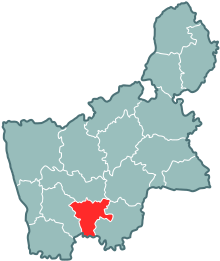
The Selwa Raion ( Belarusian Зэльвенскі раён ; Russian Зельвенский район ) is an administrative unit in the south of the Hrodsenskaya Woblasz in Belarus with the administrative center in the urban-type Selva settlement . The Rajon has an area of 869.7 km², includes 126 settlements and is divided into 7 Selsawets .
geography
The Selwa Rajon is located in the southern part of the Hrodsenskaja Woblasz. The Nachbarrajone in the Grodno Region are in the north Masty , northeast Dzyatlava , east Slonim and west Vawkavysk . In the south, the Rajon borders on the Breszkaja Woblasz (Brest administrative district).
Landscape and land use
The Selwa Rajon lies in the large landscape of the Eastern European Plain . Its landscape is largely shaped by a gently rolling hilly landscape. From south to north, the Rajon is traversed by the Selvyanka , a left tributary of the Memel . Immediately southeast of Selwa, the Selwjanka was dammed into a drinking water reservoir of 11.9 km². It is the largest reservoir in the Hrodsenskaya Woblasz. To the north of the dam, the river forms a small plain with numerous canals.
The Shchara runs along the border with the neighboring Rayon Djatlava.
At 118 m above sea level, the lowest point of the Rajon is near the Selvyanka on the border with the neighboring Masty district. The highest point (239 m above sea level) is near the village of Madsejki.
The land use of the Rajons is predominantly agricultural. 71% of the area is arable and pasture land, around 18% is covered by forest. The remainder is spread over swamps, bodies of water as well as traffic and settlement areas.
population
On January 1, 2019, 14,375 inhabitants lived in the Rajon, including 6,581 in the main town of Selwa. Around 70% of the population are Belarusians, 23% of Polish descent, 5% are Russian and around 2% have other nationalities.
history
After the area of the Rajon belonged to Poland until 1939, it fell to the Soviet Union due to the agreements of the German-Soviet non-aggression pact and was incorporated into the Belarusian Soviet Socialist Republic . On January 15, 1940, the Rajon was founded and on October 12, 1940 it was divided into 16 Selsawets. At that time he belonged to the now defunct Woblasz von Baranavichy . With an area of 849 km², the Rajon was somewhat smaller in area than it is today, but with around 45,000 inhabitants it was considerably more populous.
Shortly after the German invasion of the Soviet Union , the Rajon was occupied by German troops (June 26, 1941). In the following three years of occupation, like the rest of Belarus, it suffered considerable population losses and lost about a quarter of its population. On July 12, 1944, the area of the Rajon was liberated from the troops of the 2nd Belarusian Front . Shortly afterwards (September 20, 1944) it was incorporated into the Hrodsenskaja Woblasz.
On April 17, 1962, the Rajon was dissolved and its territory was added to the neighboring rajons of Waukawysk and Slonim. Already on July 30, 1966, this dissolution was reversed and the Rajon was newly established in its current form.
Administrative division
The Selwa Rajon is administratively further subdivided into Selsavets (Russian сельсовет / selsowjet as short form of сельский совет, Belarusian сельсавет / selsawet , in German Village Council ) and the urban settlement Selwa. The Selsawets are regional authorities in which several villages or other settlements are grouped together. The center of a Selsavet is located in an agro-town (Russian: Агрогородок, Belarusian: Аграгарадок). Agro-towns are settlements in which various facilities are available to supply the population of the Selsavets.
Attractions
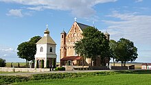
A fortified church is located near the border with the neighboring Slonim and a little north of the village of Synkawitschy . As an Orthodox church built in brick at the beginning of the 16th century, the building is now on the tentative list of world cultural heritage
traffic
Several highways run through the area of the Rajon, in Belarus known as "Republic highways" with the letter R (Cyrillic "P") and a number:
- the R99 (P99) from Grodno to the confluence with the main road M1
- the R50 (P50) from Masty to Ruschany
- the R142 (P142) from Selwa to the confluence with the M11 main road
- the R41 (P41) from Djeretschin to Slonim
The republic highways in the area of the Rajons are paved throughout and mostly in good condition. Many side roads, however, are still unpaved.
The main town Selwa is a through station on the railway line from Baranavichy to Waukawysk .
literature
AI Lakotka u. a .: Harady i Wjoski Belarussi, Hrodsenskaja Woblasz, Kniha II . Minsk 2016, ISBN 978-985-11-0908-7
Individual evidence
- ↑ a b c Official website of Selwa Raion. Retrieved July 31, 2020 (Russian).
- ^ Word document of the Belarusian land registry office (Russian) data from January 1, 2011
- ↑ Website of the national statistical authority of Belarus accessed on July 31, 2019 (Russian)
- ↑ Закон Республики Беларусь от 5 мая 1998 г. №154-З "Об административно-территориальном делении и порядке решения вопросов административно-территориальном делении и порядке решения вопросов адмистративно-территориально-. Archived from the original on June 16, 2010 ; accessed on August 7, 2020 . Law on Issues of Administrative-Territorial Division of Belarus of 1998
- ^ Tentative list: The explanations on Synkawitschy can be found in the middle of the text
Web links
- City portal - also with information about the Rajon (Russian / English)


