
Selwa
| Selwa | Selwa | |||
| Зэльвa | Зельвa | |||
| ( Belarus. ) | ( Russian ) | |||
|
|||
| State : |
|
||
| Woblasz : |
|
||
| Founded : | 1258 | ||
| Coordinates : | 53 ° 9 ′ N , 24 ° 49 ′ E | ||
| Height : | 140 m | ||
| Residents : | 6,581 (2019) | ||
| Time zone : | Moscow time ( UTC + 3 ) | ||
| Telephone code : | (+375) 1564 | ||
| Postal code : | 231940 | ||
| License plate : | 4th | ||
|
|||


Selwa ( Belarusian Зэльва , Russian Зельва ) is an urban-type settlement in the Belarusian town of Hrodsenskaja Woblasz . Selwa is the administrative center of Selwa Raion and had 6581 inhabitants as of January 1, 2019.
geography
Selwa is located on the Selwjanka river , a left tributary of the Memel in a gently undulating hilly landscape (150 to 200 m above sea level). South of the city, the Selvyanka was dammed into a large-scale drinking water reservoir (Selwjenskoje wodochranilishchje). The closest cities are Waukawysk in the west and Slonim in the east.
history
The Hypatius Chronicle mentions the existence of a settlement in the area of today's Selwa for the year 1258. This first settlement was located on a hill about 25 meters high on the edge of today's buildings. Further written evidence relates to the establishment of two Catholic churches in the then village of Groß-Selwa (1470) and the Klein-Selwa estate (1477). Since 1507 the village and estate belonged to the powiat Waukawysk in the Nawahrudak Voivodeship . In 1524 Selwa was already considered a small town, which changed hands several times in the following decades. Mikołaj Krzysztof Radziwiłł (1568) and the noble family of Sapieha (first half of the 17th century) are mentioned as landlords . In 1721 August II , head of state of Poland-Lithuania , granted permission to set up a trading post, which in the following decades developed into one of the most important in Poland-Lithuania. The development of the city was favored by its location on the great trade route that led from Minsk to Bialystok and Hrodna . In addition, the Selvyanka was navigable at that time, so that Selwa had a river port. The big Selwa fair, organized for the first time by the Sapieha, attracted traders from all over Eastern Europe and even from Italy and Austria every year in July / August. The horse trade was particularly important , which is why Selwa still bears the horse in the city's coat of arms. In 1795, after the third partition of Poland, the city fell to Russia. It belonged to the Ujesd Waukawysk and later became the center of a Volost of the same name . In 1886 Selwa was connected to the Baranavichy - Bialystok railway line , which led to a further boom.
During the First World War, the small town was under German occupation from 1915 to 1918. From 1921 to 1939 it belonged to Poland. Due to the German-Soviet non-aggression pact of 1939, the city fell to the Soviet Union and was incorporated into the Belarusian Socialist Soviet Republic . On January 15, 1940, the city became the administrative center of the Rajon of the same name. During the German-Soviet war , Selwa was occupied by German troops from the end of June 1941 to July 1944 and, like many Belarusian cities and villages, suffered great destruction and population losses.
Sacred buildings
Selwa has two churches, both of which are dedicated to the Holy Trinity . The older of the two church buildings was initially built as a uniate church from 1815 and converted into an Orthodox church in 1909. The church building has a single nave with a bell tower and apse .
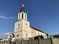
The much larger Catholic Trinity Church was built in 1912/1913 in the neo-Gothic style. The three-aisled church building is surmounted by two high bell towers. From the 1950s the building was used as a warehouse and shop. In 1989 it was returned to the community and used again as a church.
The foundations of a further church building can still be seen on the hill on which the first settlement was located. According to an inscription on a small monument not far from these remains, the first church was built on this site in the 15th century. According to the information on the history of Selwa in the city portal, this was the church whose construction on the "church hill" for the year 1470 was mentioned in writing. This church, a wooden church on stone foundations, had at least four follow-up buildings. The last church building was made of stone and brick and was finally destroyed in World War II.
The synagogue with its elaborately carved Torah shrine was also destroyed in World War II .
The Orthodox Church

The Catholic Church

The church on the "church hill" before 1918, destroyed in World War II

Foundations on the "church hill" today with a monument on the left

The synagogue before 1939

.jpg)
.jpg)

.jpg)
Population development
The oldest indication of the population of Selwas comes from the year 1829 and names 1103 inhabitants for this year. By 1897 this number had grown to 2,879. The next information can only be found again for the year 1959 with 2382 inhabitants. After that, the town's population grew rapidly and reached its peak with around 8,400 inhabitants at the turn of the millennium. Since then, Selwa, like many villages and small towns in Belarus, has suffered a sharp decline in population. The reasons for this are the general demographic development in Belarus as well as a strong rural exodus due to a lack of income opportunities in structurally weak rural areas.
traffic
Selwa is on the "Republic Highway " R99 ( Cyrillic P99 ), a trunk road that begins in Hrodna and joins Magistrale 1 (M1) east of Slonim . Between the Polish-Belarusian border crossing at Berastawiza and the confluence with the M1, the R99 forms an important transit road and is subject to a toll.
The R50 (P50) connects the city with Ruschany in the south and Masty in the northwest. The R142 (P142) leads north-east towards Djatlawa .
Selwa is also a through station on the railway line from Slonim to Waukawysk.
Others
The writer Laryssa Henijusch lived in Selwa after she was released from a Soviet camp until her death. A memorial in front of the Orthodox Church commemorates them. Her grave is just outside the city.
After the end of the fighting in the Selwa region in July 1944, the remains of 506 soldiers and 12 partisans were buried in a communal grave on the "church hill". In 1958 a memorial was erected over the grave. In 1985 the memorial was redesigned with 17 m high steles and 3 monumental figures depicting a soldier, a partisan and a mother. In 2014, the complex was expanded to include a smaller memorial for those who fell in the war in Afghanistan and some military exhibits.

Monument to Laryssa Henijusch

The burial place
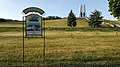
Community grave and war memorial with information board


literature
- AW Kowsch et al. a .: Pamjaz Selwenski Rajon. Minsk 2003, ISBN 985-6351-17-0 .
Web links
- City portal (Russian, English)
Individual evidence
- ↑ Website of the national statistical authority of Belarus accessed on July 30, 2019 (Russian)
- ↑ Information from the city portal accessed on August 3, 2019 (Russian)
- ↑ a b A.I. Lokotko, ONKnyazeva, u. a .: Tourist Mosaic of Belarus , Minsk 2013, ISBN 978-985-08-1571-2 , p. 340.
- ↑ Zelva . In: My Grodno . German-speaking guide to the city and region of Grodno
- ↑ Section "Sights" in the city portal , accessed on August 9, 2019
- ↑ Archive data on Selwa (Belarusian) accessed on August 8, 2019
- ↑ Cities and Towns of Belarus. Retrieved August 8, 2019
- ↑ Website with information on electronic toll collection in Belarus (also in German)