M11 (Belarus)
| Main road M11 in Belarus | ||||||||||||||||||||||||||||||||||||||||||||||||||||

|
||||||||||||||||||||||||||||||||||||||||||||||||||||
| |
||||||||||||||||||||||||||||||||||||||||||||||||||||
| map | ||||||||||||||||||||||||||||||||||||||||||||||||||||
| Basic data | ||||||||||||||||||||||||||||||||||||||||||||||||||||
| Operator: | Белавтодор / Belavtodor | |||||||||||||||||||||||||||||||||||||||||||||||||||
| Start of the street: |
Ivazevichy ( 52 ° 47 ′ N , 25 ° 33 ′ E ) |
|||||||||||||||||||||||||||||||||||||||||||||||||||
| End of street: |
Voranava ( Šalčininkai ) ( 54 ° 17 ' N , 25 ° 23' O ) |
|||||||||||||||||||||||||||||||||||||||||||||||||||
| Overall length: | 191 km | |||||||||||||||||||||||||||||||||||||||||||||||||||
|
Woblasts : |
||||||||||||||||||||||||||||||||||||||||||||||||||||
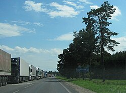
| The M11 near the Lithuanian border | ||||||||||||||||||||||||||||||||||||||||||||||||||||
|
Course of the road
|
||||||||||||||||||||||||||||||||||||||||||||||||||||
The M 11 is a trunk road in Belarus . It leads from Iwazewitschy in a northerly direction via Lida to the Lithuanian border at Šalčininkai .
history
This road belonged to the territory of the Second Polish Republic between 1921 and 1939 and was declared a state road ( droga państwowa ) by the Polish Road Act of June 23, 1921 .
course
| 0 km | Junction from the M 1 at Ivazewitschy |
| 13 km | Byzen |
| 41 km | Slonim |
| 61 km | Paulawa |
| 69 km | Kasloushchyna |
| 91 km | Djatlava |
| 114 km | Beliza |
| 128 km | Bjarosauka |
| 136 km | Crossing the M 6 |
| 144 km | Lida |
| 176 km | Woranawa |
| 187 km | Benjakoni |
| Lithuanian border |

