Altitude mark


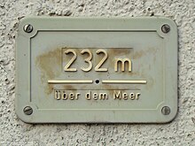
In common parlance, an altitude mark is used to denote a surveying point to indicate an altitude in meters above sea level.
In the technical terminology of geodesics , only a special type of height control point (HFP) is referred to as a height marker (HM).
- Elevation marks of the Royal Prussian Land Survey
- Elevation marks of the Royal Saxon Land Survey (Land leveling)
- Elevation marks of the Reich Office for Land Recording
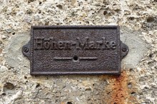
The distinctive hole mark with protective cover and the inscription "European degree measurement (height mark)" was marketed at the Nivellements by the Royal Prussian Geodetic Institute . As with the more recent design, both cover a cylindrically drilled hole mark or a brass hole bolt, which also has a hole and is inserted flush with the wall. The height reference point is the center of the hole.
Elevation marks have not been used since 1945.
History
The design of the height marks and hole marks has been adapted to the requirements for good marking in the course of the technical development of geometric leveling since the middle of the 19th century. The organizational and political structures before and after the founding of the Reich in 1871, the requirements of the railway and hydraulic engineering and the activities of Baeyer , Bauernfeind , Schreiber and others. a. lead to different design of the marking.
The different types of construction can be assigned to the degree measurement levels with the hole marks used and the levels of the trigonometric department of the Royal Prussian State Recording (KPL) as well as its successor authority with the height marks. The degree measurement levels (1865-1894) were processed by scientific institutes or degree measurement commissions . The precision leveling of the KPL carried out in roughly the same period (1868-1894) extended to the territory of the Kingdom of Prussia including Alsace-Lorraine with the exception of the states of Baden, Bavaria, Mecklenburg, Saxony and Württemberg .
Height mark design
The trigonometric department of the Königlich Preußische Landesaufnahme rejected the design of the perforated marks from the start and Schreiber introduced elevation marks with a protruding, arched head with a view to permanent marking as an improvement from 1882, the highest point of which is defined as the high point. The height control points have been designed since the first measurements from 1868 in such a way that the leveling staff, with its contact surface at right angles to the longitudinal axis, directly hits the highest point of the marking z. B. the height mark can be placed.
In Prussia, the height mark made of forgeable cast iron has a head of 144 mm diameter with the inscription "KÖNIGL.PREUß.LANDES-AufnahME". The shaft of the height mark with a length of 190 mm and a crossbar was in the masonry of stable buildings such B. Church towers cemented about 1 m above the ground. In the middle there is a bronze plate with a diameter of 60 mm - in some cases with the height number that was only screwed in after the final calculation of the height value. In the case of later renewal measurements, a smooth sealing plate without a height number was used again because of the expected change and later left that way for reasons of cost.
On all lines of the original leveling that were leveled from 1882 onwards, height markers were marketed at intervals of 10 km at the same time as the neighboring height control points. In the case of older lines, the height marks were only marketed and leveled afterwards.
The part "KÖNIGL." Can be found in the inscription of the height markers still preserved after almost 140 years and used for leveling. or "PREUß." absence. After the November Revolution of 1918/19, which led to the overthrow of the monarchy in the German Reich in the final phase of the First World War , these parts of the writing were subsequently filed down during surveying work.
In the case of the Saxon state leveling system (1909–1927), height marks with a shaft and crossbar made of cast iron and a head made of brass were used approximately every 10 km and at junctions of the leveling network. The inscription "KÖNIGL.SÄCHS.LANDESNIVELLEMENT - METER above NORMAL-ZERO" is on the outer ring of the face. The height above sea level that was determined after the work was completed was no longer engraved for reasons of cost.
Elevation marks produced since 1937 bear the national emblem in the middle and the inscription "German Reich - Höhenmarke" on the edge.
Type punch mark
As early as 1873, Christian August Vogler focused attention on the shape, location and usability of the hole marks, as in the previous years a large number of mostly unsuitable reference points such as cylindrical glass marks, bronze plates in rocks, smoothed horizontal surfaces in the capstones of structures on railways and roads , Steps, plinths on buildings, etc. as the starting point for the leveling staff .
Attempts were made in various ways to determine the results of the leveling in the terrain clearly, permanently and for convenient use. A mathematical point was also completely clear in the sense of the scientists of the European degree measurement.


As part of the conferences on the European degree measurement, Professor Bauernfeind reports on the willingness of Oberbergrat Julius Weisbach - who is participating in the conference for Saxony - to obtain height control points based on the Saxon model for Bavaria, which are also used in a similar form by the Royal Prussian Geodetic Institute for the leveling of sea levels can also be used in northern Germany (Prussia).
The cylindrical bolts made of brass or copper with conical head ends, a length of 100 mm and 20 mm in diameter, were fastened horizontally about 2 m above the ground in the masonry of a permanent house (usually a station building) with lead rings and cement mortar so that only the front side of the Cylinder remains visible. The center is marked by a 10 mm deep drill hole with a 2 mm diameter and the center of the drill hole on the outer face is the height point. Before spreading with mortar , fine adjustment of the bolt could be made by driving the lead rings, a steel centering pin in the drill hole and a spirit level. In front of the bolt, a cast iron protective cover was fastened with wooden dowels, which had a hole about the middle of the diameter of the hole in the bolt. Hole and bore were brought exactly to coincide. The round or rectangular covers are labeled "Höhenmarke" or "European degree measurement" and have a cast rib on both sides of the hole, which roughly represents the level of the height point.
Although this type of construction has a clearly defined height point, it has the disadvantage that its use requires special devices and devices. An exactly horizontal pin had to be inserted into the hole, on which a hammock was hung. Its zero division had to be exactly in the axis of the pen. Other auxiliary devices were the staff slide with a horizontal reading line of a diopter, which was used at the Bavarian Precision Leveling from 1869, which required aiming at the center of the borehole and this height had to be transferred with a special scale to the division of the staff next to the height point. To avoid errors, the procedure was repeated on the other edge of the lath and the result was averaged.
Later, insertable levels were made in a brass shaft about 20 cm long, which had a round pin for the drill hole on one side and a cutting edge for transferring it to the leveling staff on the other. What all methods had in common, however, was the cumbersome and time-consuming use.
Immediately below these historical points, or at another suitable point in the same building, you will find height control points that were later used , which enable the height to be reduced by directly placing the leveling rod.
In southern Germany the type of punch mark with protective cover was often used. Hole marks can only be found sporadically in northern Germany at stations of old railway lines in the course of the degree measurement leveling carried out by the Royal Prussian Geodetic Institute . The entire area of the Kingdom of Prussia including Alsace-Lorraine has been marketed and leveled by the Royal Prussian Land Survey with other height control points such as the height markers.
Individual evidence
- ↑ GeoInfoDok 7.0: AFIS object type catalog (point marking). Website of the AdV. Retrieved June 5, 2020.
- ↑ About goals and tools of geometric precision leveling Bayerische Staatsbibliothek. Retrieved June 24, 2020.
- ^ The Bavarian Precision Level, Carl Max Bauernfeind, Munich, 1870 Bavarian State Library. Retrieved June 24, 2020.