Pians
|
Pians
|
||
|---|---|---|
| coat of arms | Austria map | |
|
|
||
| Basic data | ||
| Country: | Austria | |
| State : | Tyrol | |
| Political District : | Landeck | |
| License plate : | LA | |
| Surface: | 2.89 km² | |
| Coordinates : | 47 ° 8 ' N , 10 ° 31' E | |
| Height : | 856 m above sea level A. | |
| Residents : | 800 (January 1, 2020) | |
| Population density : | 277 inhabitants per km² | |
| Postal code : | 6551 | |
| Area code : | 05442 | |
| Community code : | 7 06 18 | |
| NUTS region | AT334 | |
| Address of the municipal administration: |
Hno. 47 6551 Pians |
|
| Website: | ||
| politics | ||
| Mayor : | Harald Bonelli (Our Pians - UP) | |
|
Municipal Council : (2016) (11 members) |
||
| Location of Pians in the Landeck district | ||
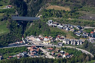
 The center of Pians. The Lattenbach bridge in the background connects two short tunnels of the Arlberg expressway. |
||
| Source: Municipal data from Statistics Austria | ||
Pians is a municipality with 800 inhabitants (as of January 1, 2020) in the Landeck district in the state of Tyrol ( Austria ). The community is located in the judicial district of Landeck .
geography
location
Pians is on the main road to the Arlberg on a slope. With the completion of the Arlberg expressway tunnel , the town was relieved of through traffic. To the west of Pians, the rivers Rosanna from the Stanzer Tal and Trisanna from the Paznaun meet and unite to form the Sanna .
Community structure
The municipality includes the following two localities (population in brackets as of January 1, 2020):
- Pians (598)
- Square (202)
The parish consists of the cadastral parish of Pians.
The neighboring communities are Grins , Landeck and Tobadill .
history
The climatically favorable area was already settled in pre-Roman times. The name Pians is derived from the Latin "Pedaneus", which means something like bridge or footbridge. Quadratsch is also of Latin origin and is derived from "ager quadratus", old Roman soldiers who have established a veterans' settlement here. The population of Pians is called Pianner , not Pianser . The reason is the Rhaeto-Romanic origin of the place name. This ends with the Latin nominative ending -s, which is why the genitive is formed without -s.
In the Middle Ages, Pians was a street crossing point; over time, many traders such as Wagner and Sattler settled down. In 1849 a fire raged, which destroyed many houses. The Arlbergbahn was built from 1880 to 1884 and Pians received a train station. Local rail transport in the Stanzer Valley has now been discontinued.
Culture and sights
- Parish Church of the Holy Trinity
- The chapel of St. Margaretha dates from the 14th century and contains frescoes from the 15th century. The sculptor Michael Lechleitner carved the altar from Grins around 1650.
- Chapel of St. Anthony of Padua in Quadratsch
- Way Chapel St. Joseph
economy
The most important employer is the bacon and sausage producer Handl Tyrol , whose products are also marketed nationwide. There are also smaller craft businesses and some tourism. Agriculture is in decline.
Web links
- 70618 - Pians. Community data, Statistics Austria .


