
Serfaus
|
Serfaus
|
||
|---|---|---|
| coat of arms | Austria map | |
 |
|
|
| Basic data | ||
| Country: | Austria | |
| State : | Tyrol | |
| Political District : | Landeck | |
| License plate : | LA | |
| Surface: | 59.73 km² | |
| Coordinates : | 47 ° 2 ' N , 10 ° 36' E | |
| Height : | 1429 m above sea level A. | |
| Residents : | 1,139 (January 1, 2020) | |
| Population density : | 19 inhabitants per km² | |
| Postal code : | 6534 | |
| Area code : | 05476 | |
| Community code : | 7 06 24 | |
| NUTS region | AT334 | |
| Address of the municipal administration: |
Gänsackerweg 2 6534 Serfaus |
|
| Website: | ||
| politics | ||
| Mayor : | Paul Greiter ( General Citizen List Serfaus ) | |
|
Municipal Council : (2016) (13 members) |
||
| Location of Serfaus in the Landeck district | ||
  |
||
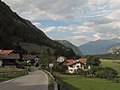
 Serfaus in summer |
||
| Source: Municipal data from Statistics Austria | ||

Serfaus [ sɛr'faːʊs ] is a municipality with 1139 inhabitants (as of January 1, 2020) in Tyrol , Austria .
geography
location
The place is in the upper court about 500 m above the Inn valley on a flat south-facing slope of a terrace, the sun terrace . The village shares this valley shoulder at the foot of the Samnaun group with the communities of Fiss and Ladis .
Surrounding mountains
The ridge rises above the village from Furgler ( 3004 m above sea level ) to Schönjoch ( 2491 m above sea level ). Opposite the valley is the Glockturmkamm with the Pfroslkopf ( 3148 m above sea level ) and out of the valley the entrance of the Kaunertal valley and the Kaunergrat with the Aifnerspitze ( 2779 m above sea level ), both Ötztal Alps .
Community structure
The municipality has only one cadastral municipality , one village and one counting district Serfaus .
|
structure
|
||||||
|
Legend for the breakdown table
|
Neighboring communities
Kappl * is to the northwest and Fiss to the northeast . To the west is See and to the east Ried in the Oberinntal . In the south-west of Serfaus there is the village of Pfunds in the south of Tösens
history
The oldest finds lead back to the Bronze Age . A Bronze Age fireplace (approx. 3200 years ago) on the Komperdell speaks in favor of pasture use (resting place for shepherds) or a hunting ground. The Zienerbichl in the south-west of the Serfaus municipality was examined more closely archaeologically . The results suggest a late antique and medieval use of the hill.
Some pre-Roman field names are still reminiscent of the early settlers, and Celtic traces can still be found. Ancient historians refer to the Alpine inhabitants of the area as Raetians . The Romans conquered in 15 BC The area and in the course of time the Rhaetians and Romans mixed, the people of the Rhaeto-Romans emerged . The Romansh language, as it is still spoken in Graubünden , has been preserved in many place, hamlet and field names to this day. The German-speaking Bavarians began to settle in the 6th century , and from around 1350 also a few Walsers , which gradually pushed the Rhaeto-Romanic language out of active use of the language.
The place itself was first mentioned in the eleventh century. The villages of See and Kappl were partially settled from Serfaus . Serfaus is considered "the oldest Marian pilgrimage site in Tyrol". The Romanesque pilgrimage church goes on 10/11. Century back. The Madonna of Serfaus, kept in the church, was born around 1000 AD. created. Since 1516 there has been a parish church next to the sanctuary. The medieval pilgrimage church of St. Georgen, which is one of the oldest churches of the Upper Court, was also important.
As in many other places in Tyrol, the first tourists arrived in the late 19th century. In the early 20th century tourism became the town's most important source of income.
In 1921 a power station was built in Serfaus. The water was led from a Waal through a pressure pipeline to the machine house (which today still stands a little above the cable car).
In 1929 a refuge for the Rhineland-Cologne Alpine Club section , the Cologne House, was built. This paved the way for the first tourism.
On September 16, 1942, there was a large village fire in Serfaus, in which 14 houses were destroyed. 16 households with 89 people were left homeless and the estimated damage was around 650,000 Reichsmarks . The village could only be rebuilt after the end of the Second World War . However, it was no longer rebuilt in the classic style of a Rhaeto-Romanic cluster village , but in a much more relaxed style.
With around 7,500 guest beds, the townscape today is strongly influenced by tourism , while the western part of the village still has a strong Rhaeto-Romanic character.
In the 1970s, Dorfstraße was the only access to the Komperdell ski area that was closed to private traffic, and skiers were brought to the lifts by bus. Due to a further increase in the number of guests, the Serfaus underground railway was opened in 1985 and later expanded, which can transport 3000 passengers per hour underground over a length of 1280 m.
politics

Serfaus was originally part of the Ried judicial district in Tyrol and became part of the Landeck judicial district after the Ried judicial district was dissolved in 1978 .
Community representation
One party took part in the municipal council elections in 2016, the general list of citizens of Serfaus - Paul Greiter . Paul Greiter is also mayor.
coat of arms
|
|
|
|
| Serfaus - Fiss - Ladis , municipal coat of arms | ||
|
|
||
| Serfaus – Fiss – Ladis , tourist region | ||
- Shield quartered in red and gold , on the right upper corner a sun , on the left lower corner a golden ibex horns .
The sun means that the municipality of Serfaus belongs to the small region of the sun terrace . The ibex horn is a reminder of the noble sex of the lords of Serfaus , named in the 13th century , who had an ibex in their coat of arms.
The coat of arms was awarded on May 28, 1974.
Regional policy
The community is part of the Tyrolean Sun Terrace Planning Association and the Serfaus – Fiss – Ladis tourist region . The seat of the planning association is Fiss , and the mayor's chairman is Markus Pale. The tourist office is based in Serfaus ( Serfaus-Fiss-Ladis Information ; it also holds 80% of Serfaus-Fiss-Ladis Marketing GmbH).
Capital of the municipality
| Serfaus ( village ) ( capital of the municipality ) | |
|---|---|
| Basic data | |
| Pole. District , state | Landeck , Tyrol |
| Pole. local community | Serfaus ( KG Serfaus ) |
| Locality | Serfaus |
| Coordinates | 47 ° 2 '16 " N , 10 ° 36' 26" E |
| height | 1429 m above sea level A. |
| Statistical identification | |
| Counting district / district | Serfaus (70603 000) |
 Serfaus, from Madatschen |
|
| Source: STAT : index of places ; BEV : GEONAM ; TIRIS | |
The main town of the municipality is the village of Serfaus . It is in the valley above Ried on the southern edge of the sun terrace. The valley shoulder breaks off suddenly around the place, east in the wall of Der Tölder to the Inn valley, south to the Argebach . In between, a spur pushes into the Inn valley.
The settlement covers a little more than 1½ kilometers at altitudes between about 1400- 1500 m above sea level. A. (the village church is at 1,429 m above sea level ), and thus at the same height as the neighboring town of Fiss to the northeast . The majority of the community's population lives in the village.
Neighboring places
| Samnaun (Gem. Serfaus and Fiss ) ∗ |
Fiss (Gem. Fiss ) |
|
| St. Zeno |
.svg)
|
St. Christina ( Gem.Ried iO ) |
| Madatschen | St. Georgen | Stone Bridges (Gem. Tösens ) |
- ∗ The scattered houses of the ski area
Economy and Infrastructure
tourism

Tourism, especially winter tourism, has shaped the town in the Serfaus-Fiss-Ladis region for many decades . With 7,500 guest beds, Serfaus is the town with the most tourism in the Upper G'richt . Alongside Ischgl , Sölden and St. Anton am Arlberg, Serfaus is now one of the most famous tourist regions in Tyrol - this is not least due to the Serfaus – Fiss – Ladis tourist association , which brings together the local ski areas.
In the tourism year 2006 Serfaus booked 892,264 overnight stays, which means an increase of 1.9% compared to the previous year. Serfaus ranks 5th among the Tyrolean municipalities in terms of the number of overnight stays. District-wide, this means third place behind Ischgl and St. Anton am Arlberg. This is the equivalent of 757 overnight stays per inhabitant. This is the peak value for all of Tyrol.
Serfaus has developed into a preferred vacation spot for Orthodox Jews from Israel and other countries in recent years . Some hotels and supermarkets have adapted to their needs, such as kosher food .
Mountain railways

Serfaus is the starting point of the Komperdellbahn, which opens up the ski area, which extends up to an altitude of 2820 m.
Subway
Through the village leads underground as a cable-operated air cushion cableway the subway Serfaus . With two cabins, it connects the parking lot at the entrance to the village via the church and center stations with the mountain railway station. The railway, which opened in 1985, relieves the town of individual traffic and ski buses. It is the third shortest underground in the world. A major overhaul was carried out between 2017 and 2019 and its capacity doubled to 3000 passengers per hour.
Culture and sights
Schönegg, the village
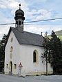
Tschuppbach, chapel


- Old parish and pilgrimage church of Our Lady in the Forest
- New parish church of the Assumption
- Church tower, cemetery chapel and cemetery
- Filial church St. Georg ob Tösens
- Plague chapel St. Sebastian on the Muiren
- Mariahilf Chapel in Tschuppach
- Chapel of St. Ursula in Untertösens
- Chapels of the Holy Family in the hamlet of Madatschen
- Serfaus castle ruins
- Earth pyramids near the cable car valley station
Personalities
Honorary citizen
- Franz Greiter (* 1929), member of the Tyrolean state parliament 1988–1990, municipal councilor in Serfaus 1956–1992
- Hugo Westreicher (1933–2018), member of the Austrian National Council 1970–1986, mayor of Serfaus 1973–1980
Sons and daughters of the church
- Paul Ivic (* 1978), cook
literature
- Robert Klien (Ed.): Serfaus. Serfaus 2002.
Web links
- Community website
- Entry on Serfaus in the Austria Forum (in the AEIOU Austria Lexicon )
- 70624 - Serfaus. Community data, Statistics Austria .
Individual evidence
- ↑ a b lit. Robert Klien: Serfaus. 2002.
- ^ The oldest pilgrimage to the Virgin Mary , homepage of the Diocese of Innsbruck
- ^ Kölner Haus , accessed on November 4, 2015
- ↑ Transport: Renewed Serfaus subway opened. In: tirol.orf.at. July 13, 2019, accessed July 13, 2019 .
- ↑ [1] , serfaus.gv.at
- ↑ Justification literally; Municipal coat of arms, serfaus.gv.at
-
↑ Imprint , serfaus-fiss-ladis.at;
Serfaus-Fiss-Ladis Marketing GmbH in Serfaus . Commercial register data Creditreform / firmenabc.at - ↑ Not entirely kosher Süddeutsche Zeitung Magazin issue 44/2010
- ↑ Dorfbahn Serfaus on YouTube , March 6, 2008
- ↑ Transport: Renewed Serfaus subway opened. In: tirol.orf.at. July 13, 2019, accessed July 13, 2019 .
- ^ Dehio Tirol 1980
- ↑ https://www.mein Bezirk.at/landeck/c-folk/franz-greiter-90-jahre-und-noch-kein-bisschen-leise_a3388440 , accessed on May 16, 2019.
Flags | Fendels | Fiss | Flow | Flirsch | Galtür | Grin | Ischgl | Kappl | Kaunerberg | Kaunertal | Kauns | Ladis | Landeck | Nauders | Pettneu am Arlberg | Pfunds | Pians | Prutz | Ried im Oberinntal | St. Anton am Arlberg | Schönwies | Lake | Serfaus | Spiss | Punching at Landeck | Strict | Tobadill | Tosses | Zams
Cadastral municipality and locality: Serfaus
Village:
Serfaus |
Weiler:
Madatschen •
Tschupbach |
Rotten:
Feld •
Schönegg •
St. Zeno •
Untertösens |
Scattered houses:
Heuberg •
Samnaun |
Other locations:
Axsterhütte •
Hexenseehütte •
Kölner Haus •
Komperdellalpe •
St. Georgen
Counting district: Serfaus