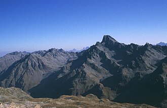
Bell tower crest
The Glockturmkamm is a mountain ridge about 20 kilometers long in the Austrian state of Tyrol . It runs in a north-south direction, parallel to the Kaunergrat and Geigenkamm to the east and, like them, belongs to the Ötztal Alps . Compared to the Kaunergrat and Geigenkamm, the Glockturmkamm is less glaciated.
Location and limitation
It is limited in the east by the Kaunertal , in the northwest by the Oberinntal and in the west by the Radurschltal . In the north, the ridge ends at the Mittagskopf near Fendels (1352 m) into the Oberinntal. In the south, the Glockturmkamm ends at the Weißseejoch , located at an altitude of 2960 meters, where it branches off from the main Alpine ridge . The Langtauferertal follows on the South Tyrolean side . A few glaciers can only be found in the area of the bell tower ridge in the south.
Summit (selection)
From north to south the ridge gains height. The most northerly important peak is the Rote Schrofen with a height of 2702 m . About three kilometers to the south follows the 2916 meter high Feichtener Karlspitze , southwest above Feichten in the Kaunertal , then, as the first three thousand meter high, the 3001 meter high Outer Rifekarspitze . At the Pfroslkopf , the Glockturmkamm reaches a height of 3148 m, and then slightly loses height again with the Vorderen Gebhardspitze (3114 m) and the Rotschragenspitze (3112 m). In the bell tower , the ridge finally reaches its highest point at 3353 meters.
Mining
On the western edge of the Glockturmkamm, southeast above Tösens in the Bergler and Platzer valleys , ore mining for lead and silver was operated from 1539 to 1610 at an altitude of over 2800 meters. However, with the advance of the Bergler Ferners in the so-called Little Ice Age , mining was prevented until the 19th century. From 1858 to 1910 the ore mining was resumed with interruptions, whereby economic factors such as the market price for silver and lead always played a role.
Tourist development
Three Alpine Club huts can serve as bases for alpine tours . In the south of the area are the Hohenzollernhaus and the Gepatschhaus , in the north the Anton-Renk-Hütte . There are hiking trails that cross the ridge on the Roten Schrofen and on the Feichtener Karlspitze. A north-west-south-east crossing is possible via the Rifekarscharte (east of the Outer Rifekarspitze). At the Rotschragenjoch , north of the bell tower, a last transition in an east-west direction is possible.
Literature and map
- Walter Klier : Alpine Club Guide Ötztaler Alpen Bergverlag Rudolf Rother , Munich 2006, ISBN 3-7633-1123-8
- Verlag Freytag & Berndt , hiking map 1: 50,000, sheet WK 253, Landeck, Reschenpass, Kaunertal, Tiroler Oberland
- Alpine Club Map 1: 25,000, sheet 30/4, Ötztal Alps, Nauderer Mountains (only for the southern area around the bell tower)

